Platte River
| Platte River | ||
|
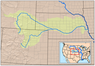
The catchment area of the Platte River with the South and North Platte Rivers |
||
| Data | ||
| Water code | US : 835915 | |
| location | Nebraska (USA) | |
| River system | Mississippi River | |
| Drain over | Missouri River → Mississippi River → Gulf of Mexico | |
| confluence | from North Platte River and South Platte River in North Platte 41 ° 6 ′ 50 ″ N , 100 ° 40 ′ 33 ″ W |
|
| Source height | 845 m | |
| muzzle | north of Plattsmouth in the Missouri River Coordinates: 41 ° 3 '8 " N , 95 ° 52' 50" W 41 ° 3 '8 " N , 95 ° 52' 50" W
|
|
| length | 499 km | |
| Catchment area | 233,100 km² | |
| Left tributaries | Loup River | |
| Navigable | No | |
|
A great blue heron and a non-adult bald eagle on the Platte River in Nebraska. |
||
The Platte River [ plæt ] is a 499 km long right tributary of the Missouri River in the US state of Nebraska .
Its river system is one of the most important components of the catchment area of the Missouri River and drained much of the Great Plains in Nebraska and the eastern Rocky Mountains in Colorado and Wyoming . The river was instrumental in the expansion of the United States westward as it ran along major travel routes, including the Oregon Trail and the Mormon Trail . In the 18th century, the river was also known as the Nebraska River by French fur traders .
Run
The river arises in western Nebraska in North Platte by the confluence of its headwaters North Platte River and South Platte River , which in the Rocky Mountains in Colorado near the Continental Divide spring. It flows in a large arc first in a south-easterly and then in a north-easterly direction and on its way passes the cities of Gothenburg , Cozad , Kearney and Grand Island . The Loup River flows into it eight kilometers southeast of Columbus . The Platte River then flows east past Northbend to Fremont and then turns south. After flowing south of Omaha , it flows into the Missouri River a few kilometers north of Plattsmouth .
The catchment area of the Platte is about 233,100 square kilometers. Together with the North Platte River, it is 1,593 km long. The Platte River drains one of the driest areas of the Great Plains, and therefore its water volume is significantly less than that of other rivers of comparable length in North America. Most of its course is a wide but shallow river.
In the pioneering days, the Platteriver was humorously described as "a mile wide at its mouth but only six inches deep" and this was carried over to the Nebraska-based politician William Jennings Bryan .
In western Nebraska the bank and river bed are an oasis in the otherwise semi-arid region. The central section of the Platte River is an important resting place for the migration of waterfowl on the middle flight path of North America, such as whooping cranes and sand hill cranes .
The river has shrunk significantly in the last seven decades, which is partly due to irrigation measures, but the larger part is due to the construction of dams. These serve to extract drinking water from the growing population of Colorado, for whom the use of the groundwater is no longer sufficient.
history
The first European to explore the Platte River was the French explorer Étienne de Veniard, Sieur de Bourgmont , who in 1714 named the river “Nebraskier” . The word is from the Oto language and means "shallow water". The river was later named after the French word for flat, "flat" . For the French, the river was a valuable transport route in the fur trade with the Indians from the Pawnee and Oto tribes .
The river lay in a gray area between Spanish and French claims to the Great Plains. Joseph Naranjo , an explorer of African Indian descent, had also come to the plate and later led the Villasur expedition here to stop the French expansion. This expedition was the largest advance the Spaniards had made into the great plains.
After the area was ceded to the United States by the Louisiana Purchase , Major Stephen Harriman Long explored and mapped the river in 1820 . He played an important role in the migration west in the 19th century. Both the Oregon Trail and the Mormon Trail followed the course of the Platte and North Platte Rivers. During the 1860s, the two rivers formed the route of the Pony Express and later the route for the section of the Union Pacific Railroad when the first rail link through North America was built. In the 20th century, the valley was used to route the Lincoln Highway and later Interstate 80 , which runs parallel to the Platte and North Platte Rivers through most of Nebraska.
Literary references
The epic novel " The Colorado Saga " by the author James A. Michener is about the development of the West from prehistoric to modern times. It is set in the wider area of the fictional town of Centennial, on the Platte River, and tells the story of the Great Plains and the Platte. The river as a resting place for cranes plays an important role in the novel "The Echo of Memory" by Richard Powers .

