Willamette Valley
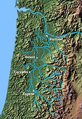
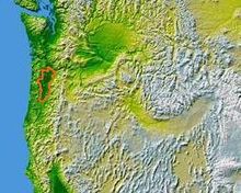
The Willamette Valley (German Willamette Valley ) is a region in northwest Oregon that surrounds the Willamette River . To the north, it extends from the mountains near Eugene to the Columbia River .
location
The Willamette Valley is bounded to the west by the Oregon Coast Range and to the east by the Cascade Mountains . To the south it is bounded by the Calapooya Mountains .
The following four districts are completely in the valley:
- Benton , Polk , Yamhill and Washington
The valley also makes up parts of the following counties:
history
The valley is one of the most fertile agricultural landscapes in the world, which is attributed to the Missoula floods of the last Ice Age. Many Europeans settled here in the 1840s who immigrated to the area via the Oregon Trail . Almost 70% of Oregon's population live here.
During the 19th century the valley was densely populated by the Kalapuya Indians . The Hudson's Bay Company controlled the fur trade here in the 1820s and 1830s. The first settlements of Europeans took place in Oregon City and Champoeg .
Management
The valley's crops are mainly berries and vegetables. In the 20th century the valley became a large wine-growing area , where the Pinot Noir and Pinot Gris grape varieties thrive.
Others
The Willamette Valley is also home to the Baskett Slough National Wildlife Refuge , where swans, ducks and geese such as Canada goose overwinter.
The Interstate 5 freeway runs north-south through the valley.
See also
literature
- Peter Adam Kopp: Hoptopia: A World of Agriculture and Beer in Oregon's Willamette Valley. University of California Press, Berkeley 2016, ISBN 978-0-520-27747-2 .


