Rio Grande
|
Rio Grande Río Bravo del Norte |
||
|
River basin of the Rio Grande |
||
| Data | ||
| Water code | US : 1385432 | |
| location | Colorado , New Mexico , Texas (USA), Mexico | |
| River system | Rio Grande | |
| Drain over | Rio Grande → Gulf of Mexico | |
| Headwaters |
Saguache County , Colorado, 37 ° 47 ′ 52 ″ N , 107 ° 32 ′ 18 ″ W |
|
| Source height | 3600 m | |
| muzzle | At Matamoros in the Gulf of Mexico coordinates: 25 ° 57 '22 " N , 97 ° 8' 43" W 25 ° 57 '22 " N , 97 ° 8' 43" W |
|
| Mouth height | 0 m | |
| Height difference | 3600 m | |
| Bottom slope | 1.2 ‰ | |
| length | 3034 km | |
| Catchment area | 607,965 km² | |
| Drain |
MQ |
160 m³ / s |
| Left tributaries | Pecos River , Devils River | |
| Right tributaries | Rio Chama , Río Conchos , Río Salado , Río Alamo , San Juan | |
| Reservoirs flowed through | Elephant Butte Reservoir , Caballo Lake , Amistad Reservoir , Falcon Reservoir , Cochiti Dam | |
| Big cities | Albuquerque , Las Cruces , El Paso , Ciudad Juárez , Nuevo Laredo , Laredo | |
The Rio Grande (as it is called in the USA ) or the Río Bravo del Norte , or Río Bravo for short (as it is called in Mexico ), is a river in these two states in North America . Both names are of Spanish origin: Río Grande means "Great River", Río Bravo (del Norte) means "Wild River (of the North)".
The Rio Grande has its source in the Rocky Mountains ( Colorado , USA) and flows south through the US state of New Mexico . On the outskirts of El Paso , the Rio Grande initially forms the border between New Mexico and Texas , shortly afterwards the city limit between El Paso and Juárez and, beginning with it, the state border between the USA and Mexico up to the confluence . Specifically, this is the border of Texas on the US side and that of the states of Chihuahua and Coahuila on the Mexican side , where it flows through the Amistad reservoir and Piedras Negras (Mexico) / Eagle Pass (Texas) , and that of Nuevo for a few kilometers León and finally that of Tamaulipas . On this border it flows through Laredo (or Nuevo Laredo ), a Falcon reservoir and McAllen / Reynosa and finally flows into the Gulf of Mexico behind Brownsville . However, by then there is not much left of the “wild river”, as it is largely tapped to irrigate agricultural areas.
With a length of 3,034 km, the Rio Grande is the third longest river in the USA after the Missouri - Mississippi and the Yukon Rivers . Of its total distance, almost 300 km are in Colorado, around 750 km in New Mexico and a little over 2,000 km in Texas.
The names of the river
The river already had a variety of names: Rio Grande, which means Great River, was also translated into the languages of various Indian tribes , where it was named Mets'ichi Chena , P'osoge and Paslápane . The Comanches called the river ocuebi .
The Spaniards arriving in the 16th century initially named the river Río de las Palmas ; because they got to know him from the mouth, where there were extensive beaches with light sand and a multitude of palm trees. Only among the Spaniards, who "rediscovered" it in various places in the early days and at that time did not yet know that it was always the same river, the Río de las Palmas, it had a multitude of names:
- Río Caudaloso (water- rich river)
- Río de la Nuestra Señora (River of Our Patron Saint )
- Río Turbio (cloudy river)
- Río Guadalquivir (named after the Guadalquivir (from Arabic "big river") in Spain)
- Río de la Concepción (River of Conception)
- Río de la Buenaventura del Norte ( Bonaventura River of the North)
- Río del Norte (River of the North)
- Río del Norte y Nuevo México ( Rivers of the North and New Mexico)
- Río Bravo del Norte (Wild River of the North)
- Río Grande del Norte (Great River of the North)
In the USA it was named Tiguex River (Tiguex was the name of the river in the language of the Tiwa , an Indian tribe that was native to New Mexico and western Texas ), River of May (River of May) and Grand River (Great River ).
The river still has two names: north of the river (in the USA) it is called Rio Grande , south of it (in Mexico) it is called Río Bravo (Wild River) or Río Bravo del Norte (Wild River of the North). The name Río Bravo was given in 1598 after two horses were killed in the waters of the river during an expedition by the Basque Juan de Oñate.
The course of the river
Colorado
The Rio Grande rises in the San Juan Mountains , which stretch from southwestern Colorado to northern New Mexico and form part of the Rocky Mountains. The source of the river is in the Rio Grande National Forest, San Juan County, Colorado at an altitude of more than 3,600 meters and is mainly fed by the snowmelt on the mountain peaks on the Continental Divide several hundred meters higher . While the snowmelt on the west side flows over the Animas River , the San Juan River and the Colorado River into Lake Powell , the snowmelt on the east side connects with the Rio Grande.
The still young Rio Grande is initially held up in a dam built from rock and earth by some farmers at the beginning of the 20th century, which is called Farmer's Junior Dam. The area behind the dam at an altitude of around 2,700 meters became known as the Rio Grande Reservoir. From here the cold water flows down a narrow stretch of about 80 km and is mainly a trout region . The still young river then spreads in the approximately 180 km long and up to 90 km wide San Luis Valley , which extends in a north-south direction between the San Juan Mountains in the west and the Sangre de Cristo Mountains in the Extends east.
New Mexico
While the Rio Grande flows leisurely through the San Luis Valley and initially maintains its speed when leaving it at the level of the Lobatos Bridge, a tremendous change occurs about 40 km below the bridge at Lee's Trail. Here the current is fast and hardly passable. Michael Jenkinson, the author of Wild Rivers of America , describes the section from the Lee Trail to the confluence with the Red River as "pure horror". On this section of just 20 km in length, the river loses around 200 meters in height.
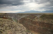
The section described above is part of the Rio Grande Gorge ; a 125 km long and up to 300 m deep canyon that the river created for itself in ancient times to flow through the basalt of the Taos plateau.
After a long stretch through largely uninhabited area, the river flows around 70 km south of Taos for the first time through a small town called Española and from here through the Santa Fe National Forest towards Albuquerque , the largest city in New Mexico.
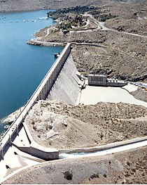
The Elephant Butte Reservoir , completed in 1916, begins about 200 km further south. It extends over a length of around 60 km and an average width of 2.4 km, making it the largest reservoir in New Mexico.
About 40 km downstream there is another reservoir, Caballo Lake , built in the 1930s , which is almost 29 km long and was once built to use water drained from the Elephant Butte reservoir to generate electricity.
The Elephant Butte Reservoir is located about 8 km north and the Caballo Reservoir around 25 km south of the city of Truth or Consequences .
Further downstream, the Rio Grande flows through Las Cruces, the second largest city in the state of New Mexico, which it leaves about 3 km southwest of the Texas border town of Anthony .
Border river between Texas and Mexico
From the western border of El Paso and the city of Juárez on the other bank of the river, the Rio Grande forms the border between the United States and Mexico for around 2,000 km to its mouth in the Gulf of Mexico .
In the 20th century, the river was artificially straightened several times, which means that its distance between El Paso and the former Fort Quitman has now been reduced by almost half: while the natural distance was 248 km, it is now only 137 km and is therefore almost with the overland route of around 130 km is identical.
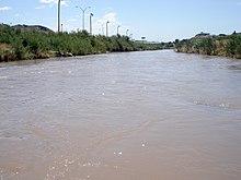
The course of the river behind Fort Quitman was not straightened and has since struggled with the problem of running out of water. Up to the tributary of the Río Conchos about 320 km downstream, just before the border towns Presidio (Texas) and Ojinaga (Chihuahua) , the Rio Grande degenerates into a largely invisible body of water that was almost completely destroyed by the numerous tamarisks there . This plant was imported from North Africa and Central Asia in the 19th century to stabilize the river basin, but has long since proven to be a disadvantage for the river, which is why the stretch between El Paso and Fort Quitman is now known as "The Forgotten River" . The river is called forgotten because it is mostly invisible and largely looks like the photo above right, which shows a period of drought from the Big Bend National Park further downstream; Because even behind the tributary of the Río Conchos, the water masses are not always huge, although the largest tributary of the Rio Grande, which originates in the Mexican state of Chihuahua, was known in earlier times for supplying the main stream with sufficient water. However, increasing dehydration to irrigate agricultural land in Chihuahua has evidently ensured that the volume of water in the Río Conchos has also decreased significantly and since then the relationship between the US state of Texas and the Mexican state of Chihuahua has been rather strained. But while the farmers in Texas are primarily blaming Mexico for the low volume of water, the Mexican settlers on the other side of the Rio Grande accuse the USA of destroying the river basin by the tamarisks. But there are also significant discrepancies between the US states of Colorado, New Mexico and Texas with regard to the use and forwarding of the water from the Rio Grande.
A few kilometers behind Presidio , the Rio Grande flows about 95 km along the Big Bend Ranch State Park which ends shortly before Lajitas . Behind Lajitas, the Rio Grande reaches Big Bend National Park , on the edge of which it forms the border between the USA and Mexico for 393 km. On the Mexican side, the Rio Grande leaves the state of Chihuahua after a little more than a third of this distance and merges into the state of Coahuila .
On the last 111 km of Big Bend National Park and the subsequent 214 km route, the current flows through a region called the Rio Grande Wild and Scenic River . It is the only area where the river goes north.
A few hundred kilometers behind the national park, the Rio Grande flows through the Amistad reservoir . This is located in the Amistad National Recreation Area , where two of the most important tributaries, the Pecos River and the Devils River, connect with the Rio Grande. From the end of the reservoir it is 19 km downstream to the Texas city of Del Rio and its Mexican sister city Acuña .
From there, the Rio Grande needs 88 km to the border towns of Eagle Pass (Texas) and Piedras Negras (Coahuila) . Over the next 92 km to Laredo (Texas) and Nuevo Laredo (Tamaulipas) , the Rio Grande leaves the state of Coahuila on the Mexican side behind the town of Hidalgo, which has only around 1,500 inhabitants, and flows along Nuevo León for a distance of only 15 km ( the only settlement here is Colombia , with a population of just under 500 ), before the river continues its last section along the state of Tamaulipas .
64 km southeast of Laredo and Nuevo Laredo is the Falcon International Reservoir with the Falcon reservoir and the tributary of the Mexican Río Salado into the Rio Grande. Halfway between the reservoir and the border towns of Reynosa (Tamaulipas) and McAllen (Texas), the Mexican Río San Juan flows into the Rio Grande near Camargo .
The last section of the river on the US side passes the Texas-based districts of Starr County , Hidalgo County and Cameron County , all of which are part of the Lower Rio Grande Valley, one of the poorest residential areas in the US. The two most important cities in the Rio Grande Valley are McAllen in Hidalgo County and its largest city, Brownsville , further downstream in Cameron County . From this and its Mexican sister city, Matamoros , there are still around 40 km to the confluence of the Rio Grande in the Gulf of Mexico . However, this is the unusual end of a river, because the Rio Grande soon spreads further and further behind these two last border towns and seeps into the river delta . It is more like the end of the river than its mouth, as the Mexican guide Gilberto Rodríguez put it to the author Jan Reid. So Jan Reid finally comes to the conclusion: "We let the Rio Grande degenerate into a river that can no longer find its way into the sea."
literature
- Paul Horgan: Great River - The Rio Grande in North American History . (1954) New edition: 1991.
Web links
Individual evidence
- ↑ Jan Reid (Ed.): Rio Grande , University of Texas Press (Austin, Texas, 2004) p. XVI, ISBN 0-292-70601-4
- ^ Jan Reid (ed.): Rio Grande (Austin, Texas, 2004) p. 132
- ^ Jan Reid (Ed.): Rio Grande (Austin, Texas, 2004) p. XIII
- ↑ Jan Reid (Ed.): Rio Grande (Austin, Texas, 2004) p. XVI
- ^ Jan Reid (Ed.): Rio Grande (Austin, Texas, 2004) p. 6
- ↑ The Handbook of Texas Online , accessed July 6, 2013
- ↑ David Baxter (text) / Laurence Parent (photos): Big River, Rio Grande , University of Texas Press (Austin, Texas, 2009) p. 88
- ↑ Jan Reid (Ed.): Rio Grande (Austin, Texas, 2004) p. 4
- ^ Jan Reid (Ed.): Rio Grande (Austin, Texas, 2004) p. 19
- ↑ Boating Waters - Elephant Butte Lake State Park , accessed October 21, 2010
- ↑ City of Truth or Consequences & Sierra County: Caballo Lake Park , accessed October 21, 2010
- ↑ a b Jan Reid (Ed.): Rio Grande (Austin, Texas, 2004) p. 58
- ↑ Fort Quitman , Ghosttowns.com (English), accessed October 23, 2010
- ↑ Jan Reid (Ed.): Rio Grande (Austin, Texas, 2004) p. 43
- ↑ Jan Reid (ed.): Rio Grande (Austin, Texas, 2004) p. 46
- ↑ David Baxter / Laurence Parent: Big River, Rio Grande (Austin, Texas, 2009) p. 32
- ↑ cf. Photo on p. 33 in Baxter / Parent: Big River, Rio Grande
- ↑ Jan Reid (Ed.): Rio Grande (Austin, Texas, 2004) pp. 86ff, 245ff
- ^ Jan Reid (Ed.): Rio Grande (Austin, Texas, 2004) p. 249
- ^ David Baxter / Laurence Parent: Big River, Rio Grande (Austin, Texas, 2009) p. 98
- ↑ Big Bend Ranch State Park - Bird Watching Sides , Trails.com, accessed October 23, 2010
- ↑ Big Bend Ranch State Park , accessed October 23, 2010
- ↑ Facts about Big Bend National Park , Trails.com, accessed October 23, 2010
- ↑ Lake Amistad ( Memento of the original from September 11, 2010 in the Internet Archive ) Info: The archive link was inserted automatically and has not yet been checked. Please check the original and archive link according to the instructions and then remove this notice. , Houseboating.org, accessed October 24, 2010
- ↑ Jan Reid (Ed.): Rio Grande (Austin, Texas, 2004) p. 314
- ↑ Jan Reid (Ed.): Rio Grande (Austin, Texas, 2004) p. XXIII
- ^ Jan Reid (ed.): Rio Grande (Austin, Texas, 2004) p. 319


