
Hidalgo County, Texas
 Hidalgo County Courthouse |
|
| administration | |
|---|---|
| US state : | Texas |
| Administrative headquarters : | Edinburgh |
| Address of the administrative headquarters: |
Hidalgo County Courthouse P.O. Box 58 Edinburgh, TX 78540 |
| Foundation : | 1852 |
| Made up from: | Cameron County |
| Area code : | 001 956 |
| Demographics | |
| Residents : | 774,769 (2010) |
| Population density : | 190.5 inhabitants / km 2 |
| geography | |
| Total area : | 4099 km² |
| Water surface : | 33 km² |
| map | |
 |
|
| Website : www.co.hidalgo.tx.us | |

The Hidalgo County is a county in the US - State of Texas . The county seat is in Edinburgh . The county is heavily influenced by agriculture - especially the cultivation of citrus fruits . The population in 2016 was around 825,000. Over 90% of them are of Hispanic origin. Structural problems - especially in connection with the low-wage suppliers across the border - are the income levels, which are well below the US average, and the in some cases deficit in the supply of housing .
geography

Hidalgo County is located in southern Texas. In the south it borders on Mexico . To the east it is about 50 kilometers from the Gulf of Mexico . It has an area of 4099 square kilometers, of which 33 square kilometers are water. It is bordered clockwise by Brooks , Kenedy , Willacy , Cameron, and Starr Counties . Geographically, the area is part of the southeast Texas coastal plain , scenically, economically and socially part of the southern Texas sub-region Rio Grande Valley .
The landscape is largely flat; the height above sea level is between 12 and 60 meters. The vegetation differs in the northern, prairie- specific part of the southern part on the Rio Grande with thicker tree cover . The soils in the northern part are sandy and light, partly with limestone subsoil and are particularly suitable for cattle breeding . The soils in the southern part consist of fertile, reddish-clay colored loam soils and are well suited for agriculture. Mineral resources of the region are lime , sand , gravel and petroleum .
The main settlement center in the county is the statistical metropolitan area Edinburg-McAllen. Edinburgh, the smaller of the two cities with around 77,000 inhabitants, is the district capital. Largest city with 132,000 inhabitants is McAllen . The oldest settlement in the county is the middle town of Hidalgo (12,500 inhabitants) located directly on the Rio Grande ; Most of the old towns are in the southern part - including La Joya (4,000 inhabitants), Mission (78,000 inhabitants), Progreso (5,600 inhabitants) and Mercedes (16,000 inhabitants). Other populous cities are Weslaco (36,000 inhabitants) and Pharr (71,000 inhabitants). In general, the southern part of the county is the more densely populated. Apart from the non-incorporated settlement of Linn, which has 860 inhabitants, there are no closed towns in the northern part .
The most important east-west connecting roads are US Highway 83, which runs parallel to the Rio Grande, and US Highway 107, which runs through the county center . The most important north-south connection is the US Highway 281 , which runs through Edinburgh, Pharr and McAllen . In addition, a number of so-called farm-to-market roads lead through the district , which connect the farms and ranches in the region with the nearest market towns . There are two commercial airports in the county’s catchment area : McAllen-Miller International Airport in McAllen and Valley International Airport in neighboring Cameron County near Harlingen . Another airport is the South Texas International Airport in Edinburgh, which is owned and operated by the City of Edinburgh.
The climate in Hidalgo County is subtropical and subhumid . The temperatures range from an average of 8 ° C in January to 35 ° C in July. The average annual temperature is 23 ° C. The average rainfall is 23 centimeters per month. The heaviest rainy months are May and September.
|
Monthly average temperatures and rainfall for McAllen, Texas
Source: US climate data
|
|||||||||||||||||||||||||||||||||||||||||||||||||||||||||||||||||||||||||||
history

Pre-European history
South Texas was settled at least 11,000 years ago by people who lived near the coast as fishermen, in the hinterland predominantly as hunters and gatherers, and from around 9200 BC. Used the atlatl for hunting ( Paleo-Indians ). A low density of resources forced a more mobile way of life, while locally accumulating resources, especially food, led to the stabilization of ever more solid settlement structures. This differentiation, typical of the archaic period (6000–2500 BC), was replaced by new settlement structures between 1300 and 1400 AD. This drastic change was either due to groups migrating from the north or it resulted from the adoption of numerous cultural aspects by the local population. It is more likely that the bison herds that extended further south from around 1200 have permanently changed their way of life. How strongly the locals were dependent on the herds is controversial, but it is clear that the herds withdrew to the north in the course of the Little Ice Age around 1400. However, the tool technology was retained and transferred to other needs. The groups, later referred to as Coahuiltecan, coexisted with groups from other cultures such as the sedentary Huaxtecs who lived on the Río Pánuco in northeastern Mexico, but also with groups living in the north of Central Texas.
Before the settlement by Europeans, the area was inhabited by different Indian peoples. The term “people” is misleading in that it is today in the triangle south of San Antonio , i.e. from the mouth of the Guadalupe River westwards to Eagle Pass , then southeast to the foot of the Sierra Madre Oriental through the states of Coahuila , Nuevo León and Tamaulipas on the Gulf Coast, can distinguish about 60 archaic groups. These still represented archaic cultural groups, whose way of life, however, had begun to change through the use of bows and arrows, around 1200. The two most important of these changed groups were the Coahuiltecs and the Karankawa . While the former inhabited a larger territory inland and had their settlement focus in the areas south of the river, the territory of the Karankawa stretched up the Gulf coast into the region of Galveston . In the 18th century, the Lipan-Apaches and Comanche also expanded their radius of action into the lower Rio Grande Valley. The Comanches, in turn, pushed the Lipan out of their original territories in Colorado and New Mexico and extended their domain, the so-called Comancheria , further south.
Until the 20th century

The area was first explored by the Spanish in the 16th century. In 1638 a first expedition under Jacinto García de Sepúlveda crossed the Rio Grande, in 1687 a second under Alonso de León . In 1747 another exploration took place under the direction of Miguel de la Garza Falcón . Despite Falcón's pessimistic prognosis, another colonizer - José de Escandón - was commissioned two years later to begin building settlements in the region. The immediate consequence was the establishment of four settlements on the south side of the river - Reynosa , Camargo, Mier and Revilla (today: Guerrero).
The beginning of the settlement in the later Hidalgo County took place from these foundations. By the beginning of the 19th century, the New Spanish colonial administration issued nineteen permits for a total of 80 pieces of land on the north side of the river. The settlement of La Habitación was founded in 1774 on the site of today's Hidalgo. Among the first settlers were the large landowner Juan José Hinojosa de Ballí and the rancher José Manuel Gomez - founders of the McAllen Ranch, which was run until the 1990s. By the Texan War of Independence , the region had developed an economically viable form of ranching.
Since Mexico continued to view the area south of the Nueces River as part of the Mexican province of Tamaulipas , the question of nationality remained a matter of dispute until the American-Mexican War of 1846-1848. A consequence of the war was the Old Military Road - a supply route leading towards what is now New Mexico , which became known under the name Gila Road and was used by gold prospectors on the way to the California gold fields . By 1850 there were about 50 farms in operation. The existing cattle breeding has meanwhile been supplemented by growing vegetables and fruit . Due to the common distribution of inheritance , the old settlements of La Habitatión, Relampago and Peñitas in particular had developed into closed localities.


Initially, the territory was assigned to the counties of San Patricio and Cameron. In 1852 it was constituted independently under the name Hidalgo County. The new district was formed from parts of Cameron County, named after Miguel Hidalgo y Costilla , one of the leading champions for the independence of Mexico. The first capital was the settlement of La Habitación - renamed Edinburgh, but not identical to the current administrative seat of Edinburgh . Remote from the population center of Brownsville in neighboring Cameron County, Hidalgo County soon felt left behind. Lawless conditions spread more and more. The land disputes between long-established owners and a first wave of newly arrived Texan settlers culminated in the so-called Cortina Wars in 1860/61 - two rebellions led by the landowner Juan Nepomuceno Cortina , which pursued the goal of restoring the rights of the old owners. A high point of this dispute was the battle of La Bolsa between Cortina supporters and Texas Rangers in 1860 south of the village of Progreso. Unlike neighboring Cameron County with its coastal center Brownsville, Hidalgo County benefited little from the flourishing smuggling and trade in Mexico during the American Civil War . Instead, the area became the base of operations for organized cattle theft gangs , some of which were made up of deserters from both civil war camps .
The population remained small even after the civil war; In 1870 there were around 2,400 residents in the county. In 1875, the Texas Rangers, led by Captain Leander H. McNelly, began a campaign against the gangs on both sides of the border. Politically, the county's various groups of influencers organized themselves in networks of the Democratic and Republican parties . The Democrats and their affiliates ruled the county almost unchallenged into the 20th century . Under the aegis of the South Texas politician James B. Wells, the Democrats organized a center of power that dominated public life from sheriff elections to the appointment of judges and mayors . The local protagonist of this network was the multiple sheriff John Closner. The hostility of both main tendencies - combined with the accusation of bloc elections and other dishonest machinations - escalated violently towards the end of the 19th century. Several assassinations were carried out on Closner, the main exponent of the dominant Democrats, in the course of this confrontation . The climax of the dispute was a kind of political coup, in the course of which Closner's Republican competitors briefly proclaimed an "Independent Republic of Hidalgo" in the early 1890s and - until this practice was banned by the US government - with the levying of tariffs on the American-Mexican one Border began.
The stagnating economic situation was changed by two innovations. The first was the systematic construction of irrigation systems in the late 19th century - an improvement that greatly boosted commercial agriculture in the region. The second was the 1904 connection to the railway network of the St. Louis, Brownsville and Mexico Railway . As in the entire valley, the railway connection led to a massive influx of new settlers from the north and midwest - a development that permanently changed both the demographic composition in the county and the power structure within its elite . This development was flanked by increasing tensions on the border with Mexico. With the Garza War , an attempt had already been made in the early 1890s to overthrow the dictatorship of Porfirio Díaz through an intervention from Texan soil. The Mexican Revolution between 1910 and 1920 not only exacerbated existing tensions. In addition, he made the Valley a staging area for US troops on the train of General Pershing's Northern Mexico operation from 1913 to 1916. The long-term impact of the county was the influx of hundreds of thousands of civil war refugees : it changed the demographic and social composition of the population as much as the influx of new landowners from the north.
20th and 21st centuries

.jpg)
.jpg)
The population of Hidalgo County had increased between 1900 and 1930 from just under 7,000 to around 77,000 residents. Land prices, which in 1900 were around 25 cents per acre, had already risen to over $ 300 by 1910 . Fruit and vegetable cultivation developed more and more to the economically dominant factor. The cultivation of citrus fruits had begun around the turn of the century, as did sugar cane to a lesser extent . There were also experiments with irrigated rice fields and the cultivation of cotton . The extensive, commercial agriculture began around 1907. It became really profitable with the introduction of truck farming. It developed in the 1920s the predominant type and facilitated both the transport of goods as well as that of workers . The new district capital became Chapin - a re-establishment from 1908, which has now been renamed Edinburgh. The former La Habitatión and now Edinburgh was affected by a great flood in 1886 and was rebuilt further upstream. The new name for the former district capital was now Hidalgo.
The demographic changes in the first quarter of the 20th century had far-reaching social and political consequences. As in the rest of the Rio Grande Valley, ethnic relations have traditionally been based on balance and respect. “ Mixed marriages ” were widely accepted and common. With the massive influx of Protestant new settlers, the social structure changed. The new settlers showed little willingness to adapt to the existing cultural customs. One consequence of this was the spread of ethnically separated residential areas as well as segregated schools, shops and restaurants. “New” cities like Weslaco and McAllen were particularly affected by this practice. This form of social division had a comparatively smaller effect in “old” cities such as Hidalgo, Peñitas and Relempago. The practice of segregation had detrimental consequences, especially for the schooling of the majority of the Hispanic population. “Mexican schools” tended to be more crowded, poorly equipped and with less experienced teachers than their Anglo-American counterparts. One of the effects of ethnic segregation has been the increasing interaction between poverty and educational disadvantage.
The relocation of forces associated with the resettlement led to new power struggles within the leading elites. The wave of resettlers shook the Democratic Party network in South Texas that James B. Wells had built. To counterbalance this, the Republicans founded the Good Government League in 1914 . She was mainly supported by Angleno farmers, business people and skilled workers. The League's policy of soliciting the support of Hispanics on the one hand and massively attacking the Closner government to his successor Anderson Y. Baker on the other hand because of the (alleged) advantage of the Hispanic majority, led to a racially charged, violence and assaults on the other shaped climate. As a result, the League succeeded in reassembling the district officials and ending the power of the Wells network. In the long run, however, the dominance of the Democratic Party in the Rio Grande Valley remained unchallenged.

Ethnically, the population in 1930 was composed of two roughly equal blocks: around 41,000 people classified as "Mexican" and around 36,000 Anglo-Saxon residents. Regardless of the Great Depression in the United States, the one part of the world economic crisis represented, the population rose to 1940 to over 106,000. The conversion to truck farming was completed by then. The number of farms was around 4,300. The main crops were cotton, corn and citrus fruits. In the northern part of the county ranching was predominant; The main species were cattle , sheep and poultry . In 1934 Otto C. Woods put the first oil production plant into operation. Crude oil and the associated production of natural gas were added as a further economic factor. During the Second World War , the US Army established a military base near Hidalgo - the Moore Air Field . In the post-war era , citrus fruit production boomed even more than before. The widely practiced recourse to migrant workers , however, turned out to be a factor that contributed significantly to the exacerbation of social problems. In the wake of the civil rights movement in the 1960s, the Hispanic population increasingly organized itself into its own interest groups. One consequence of this was that Hispanics were now increasingly present in public offices. However, the fight for equality has also seen its setbacks. One expression of this was the Pharr Police Riots in 1971, triggered by structural violence by police officers against members of the Hispanic majority.
With regard to social successes, the status at the turn of the millennium was generally rated as mixed. On the one hand, the integration of the Hispanic majority had brought progress. However, the annual per capita income of the Edinburgh-McAllen metropolitan area (not to be confused with the median household income) was estimated at around 7,000 US dollars in 1987, making it the lowest in the United States. In addition, Hidalgo County had the highest unemployment rate . At times, the county's financial situation was so precarious that ongoing health programs had to be canceled before the end of the financial year. The increasing number of colonias in the county area was seen as an increasing problem - ethnically separated settlements of Hispanics, which are often characterized by inferior accommodation and an inadequate supply of electricity and running water. Another problem is the proximity to the transport routes of the Mexican narco cartels and the associated increase in drug consumption . Finally, the so-called maquiladoras - semi-finished goods - assembly companies whose presence goes back to the free trade zone established by the NAFTA agreement of 1994 are also considered controversial . On the one hand, the low-wage sector they created reduces unemployment. On the other hand, so critics, it solidifies the structural poverty in the district.
Demographics and Politics
| growth of population | |||
|---|---|---|---|
| Census | Residents | ± in% | |
| 1860 | 1192 | - | |
| 1870 | 2387 | 100.3% | |
| 1880 | 4347 | 82.1% | |
| 1890 | 6534 | 50.3% | |
| 1900 | 6837 | 4.6% | |
| 1910 | 13,728 | 100.8% | |
| 1920 | 38.110 | 177.6% | |
| 1930 | 77.004 | 102.1% | |
| 1940 | 106.059 | 37.7% | |
| 1950 | 160,446 | 51.3% | |
| 1960 | 180.904 | 12.8% | |
| 1970 | 181,535 | 0.3% | |
| 1980 | 283.229 | 56% | |
| 1990 | 383,545 | 35.4% | |
| 2000 | 569.463 | 48.5% | |
| 2010 | 774.769 | 36.1% | |
| 2017 estimate | 860.661 | 11.1% | |


The largest population increases in Hidalgo County came in two leaps: one from the early 20th century to mid-century and a second from the 1970s to the present day. During the first, the number of inhabitants rose from almost 7,000 to over 160,000, in the second from over 180,000 to over 825,000 (as of 2016). According to the US census , the county's population that year was 828,334. 404,079 of these were male , 424,255 female . 548,906 inhabitants were older than 18 years, 279,428 inhabitants were children or adolescents , 85,910 inhabitants were older than 65 years. The determined median age of 28.8 years is well below that for the United States as a whole (37.7 years) and almost 4 years below that for all of Texas (34.2 years). The largest group of the population are the Latin Americans: regardless of the question about the census declaration Race , 757,725 inhabitants or 91.5% described themselves as Hispanic or Latino . Most of them classified themselves as Mexicans; around 23,000 indicated a different origin. With 57,238 or 6.9%, whites are the second largest group of the population - albeit by a large margin. 7,851 or 0.9% characterized themselves as Asian , 3,454 or 0.4% as African-American , 556 or 0.1% as North American Indians . Finally, 1,257 or 0.2% stated that they belong to two or more ethnic groups.
The median income per household was 36,094 US dollars (USD) at the beginning of 2018 according to Quickfacts information on Census.gov . In comparison, it was well below that of the state of Texas (US $ 51,900) and the United States as a whole (US $ 53,000). The census showed 31.2% of people living in poverty and 32.0% of people without health insurance . These values were also well above the US and federal benchmarks (12.7% and 11.7% and 15.6% and 19.3%, respectively). The results on ethnic composition, median household income and other indicators deviate significantly from the overall result in the smaller units City and Town . In Weslaco, for example, one of the “new” cities, the percentage of the white population group is 11.7%, which is far higher than the average, whereas in the founding town of Hidalgo it is much lower with 1%. The two examples also show differences in terms of median age and median household income. While the median age values between Weslaco and Hidalgo are significantly different (33.3 versus 27.7), the median household income in both cities is above that of the county and in the "old" city of Hidalgo, at 38,438 US dollars, slightly above that of Weslaco ($ 36,157). The differences are even clearer when looking at the numerous colonias in the district. Muniz CDP, for example, has 1,574 residents, all of whom are of Hispanic origin. The median age is 23.8, the median annual household income is 31,419 US dollars, the proportion of people in poverty is 35% and that of people without health insurance is 43.4%.
Just like South Texas as a whole and the Rio Grande Valley in particular, Hidalgo County is a traditional stronghold of the Democratic Party. With the exception of the elections in 1860 (in which the majority of the southern Texas territories voted for the constitutional unionist John Bell ) and those in 1928 , 1952 , 1956 and 1972 (in which the Republicans won), Democratic presidential candidates always came out on top. This also applies to the 2016 , 2012 and 2008 elections . While Republicans have consistently been the stronger party in overall Texas results since the 1980s, the county's Democratic candidates achieved results of around 60% or more. In the 2016 presidential election, Hillary Clinton won around 68% of the vote in Hidalgo County, while Donald Trump only won 28%. As far as the above-average results for the Democratic Party in the Rio Grande Valley are concerned, Hidalgo County is only surpassed by Starr County in the west (Clinton's share of the vote in 2016: 79%). The other two counties in the region (Cameron and Willacy) confirm the overall trend with not quite as high shares of votes.
The preference given to candidates from the Democratic Party was also confirmed in the congressional elections . Both the 15th and 28th congressional electoral districts are assigned to supporters of the Democrats with MPs Vicente González and Henry Cuellar . The longstanding representative of the state in the US House of Representatives was the lawyer Kika de la Garza , who came from Mercedes . The most important electoral positions within the county - including those of the district judge, the district attorney and the county sheriff , are currently occupied throughout by members of the Democratic Party . JE "Eddie" Guerra, previously responsible for the fourth county district, replaced the sheriff's predecessor, who was involved in a police scandal, in April 2014 and was regularly elected in November of the same year.
Economy, employment and education


The agricultural business is also in the 21st century an important economic sector . In 2002 the county had 2,104 farms and ranches. The cultivated usable area was around 2,400 square kilometers. Over two thirds of this was used for arable farming and cultivation, 28 percent as pasture . The net profit for that year was $ 202,073,000; nine tenths of that came from harvest sales . The main agricultural products are sugar cane, citrus fruits, vegetables , grains , cotton and cattle. The agricultural production sector is flanked by food processing and mineral extraction companies. Another important economic factor is the production of crude oil and natural gas. The oil production in 2004 was 2,777,000 barrels . The tourism sector is becoming increasingly important . It is true that Hidalgo County does not benefit from tourism to the same extent as the neighboring county of Cameron on the Gulf Coast. So-called “winter Texans” (US citizens who spend the winter months on the Gulf Coast) and excursion tourists to nearby Mexico also benefit the county's economy. With the Santa Ana National Wildlife Refuge and the Las Palomas Wildlife Management Area (see section "Media, Culture and Sights" ), the district also has wildlife park areas , which also attract nature lovers in large numbers.
The most important industries , each with around 40,000 employees, are healthcare , wholesale and retail, and education . With around 20,000 employees each, manufacturing , tourism and other services follow . Local authorities consider the economic development since the financial crisis 2008/2009 to be encouraging. A 2015 report published by the county stated, however, that the economic revival hoped for by the maquiladoras did not come about as expected. Rather, many of the automotive prefabricated parts suppliers based in Reynosa, Mexico , have been affected by the consequences of the financial crisis.
The elementary , middle and high school supply are is of fifteen independent school districts covered. The following cities and communities have their own school district: Dinna, Edcouch / Elsa, Edinburg, Hidalgo, La Joya, La Villa, Lyford, McAllen, Mercedes, Mission, Monte Alto, Progreso, Pharr / San Juan / Alamo, Sharyland, Valley View and Weslaco. The South Texas College in McAllen and the University of Texas Rio Grande Valley are available for higher education . The latter is the expanded continuation of the University of Texas-Pan American - the state university for South Texas and the Rio Grande Valley founded in 1927 . The university, which also has branches in neighboring Cameron County, has around 20,000 students and is considered the tenth largest university in Texas.
Media, culture and sights


The county's main daily newspaper is The Monitor, owned by AIM Media Texas . The editorial office is in MacAllen; According to the publisher, around 36,000 printed copies also cover neighboring Starr County. There is also media focused on breaking news and local events such as the Mid Valley Town Crier and the Edinburgh Review . There are also a dozen local radio stations in the Valley , most of which broadcast their programs in Spanish . Depending on the target group, the associated music program ranges from Spanish-language border music and Tex-Mex to country and mainstream rock to popular hit parade pop . Local TV stations are also available. While some are based in the county, others are based in Brownsville and Harlingen in neighboring Cameron Counties, or in Reynosa on the Mexican side of the border.
In terms of recreational opportunities and cultural attractions, the district offers nature reserves, museums and a number of buildings and streets that are listed as Historic Places . The following are to be listed in detail:
- the Santa Ana National Wildlife Refuge , a nature reserve on the Rio Grande: Located southeast of the town of Las Milpas, it offers a wide range of wild animals - including wild specimens of the Gulf Coast jaguar . The reserve is particularly important because of the numerous bird species in the region, which have a refuge here.
- of the Las Palomas Wildlife Management Area are two 14 square kilometers in the county that have been designated as a protected area by Texas. The smaller one is near the Santa Ana Wildlife Refuge , the larger one south of the city of Weslaco.
- Twenty-two buildings designated as Historic Places and on the List of Historic Places and streets . This includes the two cinema buildings Border Theater and Teatro La Paz in Mission, the Mission Citrus Growers Union Packing Shed and the La Lomita Historic District (both in Mission), the Casa de Palmas (McAllen), the Cortez Hotel (Weslaco) and the Old Hidalgo School (Hidalgo).
- Museums and Venues: The Pumphouse Museum / World Birding Center in Hidalgo organizes guided tours and tours and specializes in bird life in the region. Other museums in the district are the Botanic Garden and the International Museum of Art & Science (IMAS) . Both are in McAllen. The largest city in the county is waiting beyond with a large shopping mall on (La Plaza Mall) and a multifunctional hall with 3,500 seats (McAllen Convention Center) .
- Folk festivals : The Citrus Fiesta has been takingplace in Mission once a year since 1932- a two-week folk festival which, among other things, serves to advertise the local citrus industry. A highlight of the fiesta is the choice of a royal citrus court with a citrus queen, citrus king and flanking princes and princesses. Another event is the Rio Grande Valley Stock Show in Mercedes - a trade fair for the livestock industry based in the Valley, which has been taking place since 1947, is organized by the local Chamber of Commerce andincludesa parade , rodeo shows and an award ceremonyas outstanding programitems. Event includes.
gallery
Cortez Hotel in Weslaco
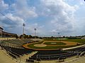
Baseball stadium on the Edinburg campus

US Army vehicle during Hurricane Dolly (2008)
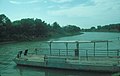
Los Ebanos Ferry across the Rio Grande

Cityscape of Mission (ca.1915)

Santa Ana National Wildlife Refuge

Street lamp in the village of San Juan

La Lomita Boulevard Commercial District, Mission

Teatro La Paz in Mission


.jpg)


Individual evidence
- ↑ See Map Land Resource Areas and article Rio Grande Valley ; both: Texas State Historical Association, accessed January 24, 2018.
- ↑ a b c d e f g h i j k l m Alicia A. Garza: Hidalgo County. Texas State Historical Association, June 15, 2010 (English).
- ^ Hidalgo County overview maps at statisticalatlas.com and Google Maps ; accessed on January 24, 2018.
- ↑ This and the following according to Bobbie L. Lovett, Juan L. González, Roseann Bacha-Garza, Russell K. Skowronek (eds.): Native American Peoples of South Texas. Edinburgh 2014 ( online , PDF).
- ↑ Joe R. Baulch: Garza War. Texas State Historical Association, June 15, 2010 (English).
- ↑ 1971: Police Riot and Protest Match in Pharr, TX . South Texas Rabble Rousers History Project, April 29, 2015.
- ↑ David M. Vigness / Mark Odintz: Rio Grande Valley . Texas State Historical Association, June 15, 2010.
- ↑ a b Ignite Hidalgo County. A Compreshensive Economic Development Strategy for Hidalgo Count 2011–2015 . Hidalgocounty.us, pp. 3-5 (PDF).
- ↑ a b Population of Cameron County . Data on Population.us, accessed January 22, 2018.
- ^ Hidalgo County, Texas . ACS Demographic and Housing Estimates, 2016, American FactFinder, accessed January 22, 2018.
- ↑ a b Hidalgo County, Texas , summary on the website of the United States Census Bureau, accessed January 22, 2018 (English).
- ^ Household Income in Hidalgo County, Texas . Overview of household income on Statisticalatlas.com, accessed on January 22, 2018 (English).
- ↑ Listed data on Weslaco, Hidalgo and Muniz CDP at: American FactFinder (ethnic composition and median age Weslaco), Census.gov (median household income Weslaco), American FactFinder (ethnic composition and median age Hidalgo), Census.gov (median household income Hidalgo ), American FactFinder (ethnic composition and median age Muniz CDP), Census.gov (median household income Muniz CDP); accessed on January 12, 2018.
- ↑ 2016 Presidential General Election Results . Interactive map on USElectionatlas.org, results accessed on January 24, 2018.
- ↑ Josh Eells: America's Dirtiest Cops: Cash, Cocaine and Corruption on the Texas Border . Rolling Stone, January 5, 2015 (English).
- ↑ List of School Districts in Hidalgo County , har.com, accessed January 24, 2018.
- ↑ See Hidalgo County, Texas listings - Newspapers , Genealogytrails.com; Radio Stations in Hidalgo, Texas , Radio-locator.com; Television Station, Hidalgo County, TX , b2b.yellowpages.com; accessed on January 24, 2018 (English).
- ↑ Santa Ana National Wildlife Refuge | Texas. FWS.gov, accessed on January 24, 2018.
- ^ Las Palomas WMA, Lower Rio Grande Valley Units. TPWD.texas.gov, accessed on January 24, 2018 (English).
-
↑ Search mask database in the National Register Information System. National Park Service , accessed October 26, 2019.
Weekly List on the National Register Information System. National Park Service , accessed October 26, 2019. - ↑ Alicia A. Garza: Citrus Fiesta . Texas State Historical Association, June 12, 2010 (English).
Web links
- Hidalgo County in Handbook of Texas (Engl.)
- Hidalgo County profiles of the Texas Association of Counties (Engl.)
List of counties in Texas
Anderson |
Andrews |
Angelina |
Aransas |
Archer |
Armstrong |
Atascosa |
Austin |
Bailey |
Bandera |
Bastrop |
Baylor |
Bee |
Bell |
Bexar |
Blanco |
Borden |
Bosque |
Bowie |
Brazoria |
Brazos |
Brewster |
Briscoe |
Brooks |
Brown |
Burleson |
Burnet |
Caldwell |
Calhoun |
Callahan |
Cameron |
Camp |
Carson |
Cass |
Castro |
Chambers |
Cherokee |
Childress |
Clay |
Cochran |
Coke |
Coleman |
Collin |
Collingsworth |
Colorado |
Comal |
Comanche |
Concho |
Cooke |
Coryell |
Cottle |
Crane |
Crockett |
Crosby |
Culberson |
Dallam |
Dallas |
Dawson |
Deaf Smith |
Delta |
Denton |
DeWitt |
Dickens |
Dimmit |
Donley |
Duval |
Eastland |
Ector |
Edwards |
El Paso |
Ellis |
Erath |
If |
Fannin |
Fayette |
Fisher |
Floyd |
Foard |
Fort Bend |
Franklin |
Freestone |
Frio |
Gaines |
Galveston |
Garza |
Gillespie |
Glasscock |
Goliad |
Gonzales |
Gray |
Grayson |
Gregg |
Grimes |
Guadalupe |
Hale |
Hall |
Hamilton |
Hansford |
Hardeman |
Hardin |
Harris |
Harrison |
Hartley |
Haskell |
Hays |
Hemphill |
Henderson |
Hidalgo |
Hill |
Hockley |
Hood |
Hopkins |
Houston |
Howard |
Hudspeth |
Hunt |
Hutchinson |
Irion |
Jack |
Jackson |
Jasper |
Jeff Davis |
Jefferson |
Jim Hogg |
Jim Wells |
Johnson |
Jones |
Karnes |
Kaufman |
Kendall |
Kenedy |
Kent |
Kerr |
Kimble |
King |
Kinney |
Kleberg |
Knox |
La Salle |
Lamar |
Lamb |
Lampasas |
Lavaca |
Lee |
Leon |
Liberty |
Limestone |
Lipscomb |
Live Oak |
Llano |
Loving |
Lubbock |
Lynn |
Madison |
Marion |
Martin |
Mason |
Matagorda |
Maverick |
McCulloch |
McLennan |
McMullen |
Medina |
Menard |
Midland |
Milam |
Mills |
Mitchell |
Montague |
Montgomery |
Moors |
Morris |
Motley |
Nacogdoches |
Navarro |
Newton |
Nolan |
Nueces |
Ochiltree |
Oldham |
Orange |
Palo Pinto |
Panola |
Parker |
Parmer |
Pecos |
Polk |
Potter |
Presidio |
Rains |
Randall |
Reagan |
Real |
Red River |
Reeves |
Refugio |
Roberts |
Robertson |
Rockwall |
Runnels |
Rusk |
Sabine |
San Augustine |
San Jacinto |
San Patricio |
San Saba |
Schleicher |
Scurry |
Shackelford |
Shelby |
Sherman |
Smith |
Somervell |
Rigid |
Stephens |
Sterling |
Stonewall |
Sutton |
Swisher |
Tarrant |
Taylor |
Terrell |
Terry |
Throckmorton |
Titus |
Tom Green |
Travis |
Trinity |
Tyler |
Upshur |
Upton |
Uvalde |
Val Verde |
Van Zandt |
Victoria |
Walker |
Catfish |
Ward |
Washington |
Webb |
Wharton |
Wheeler |
Wichita |
Wilbarger |
Willacy |
Williamson |
Wilson |
Winkler |
Wise |
Wood |
Yoakum |
Young |
Zapata |
Zavala
Coordinates: 26 ° 24 ' N , 98 ° 11' W