
San Augustine County
 San Augustine County Courthouse |
|
| administration | |
|---|---|
| US state : | Texas |
| Administrative headquarters : | San Augustine |
| Address of the administrative headquarters: |
San Augustine County Courthouse 106 Courthouse San Augustine, TX 75972 |
| Foundation : | 1837 |
| Made up from: | Original County |
| Area code : | 001 936 |
| Demographics | |
| Residents : | 8865 (2010) |
| Population density : | 6.5 inhabitants / km 2 |
| geography | |
| Total area : | 1534 km² |
| Water surface : | 167 km² |
| map | |
 |
|
| Website : www.co.san-augustine.tx.us | |
San Augustine County is a county in the eastern part of the US state Texas . The county seat is in San Augustine . Historically, it is one of the earliest settlement centers for Anglo-Saxon settlers in Texas . It is named after a Christian saint, Augustine of Hippo . The county is rural; economically, agriculture and the timber industry, which is strongly present in East Texas, dominate . Because of the nearby Sam Rayburn Reservoir and two areas designated as National Forest , there is another factor in local recreational tourism. With 8,865 inhabitants (census: 2010) and an area of 1,534 square kilometers, the county is one of the "small" Texas counties. The only city in the county is San Augustine; The town of Broaddus in the southern part of the district is also given the status of Town .
geography
.jpg)
San Augustine County is located in the far east of Texas, not far from the state line with Louisiana . Its area is 1,534 square kilometers; 167 of them are bodies of water. The southern border forms the Sam Rayburn Reservoir - an elongated reservoir that dams the lower reaches of the Angelina River . The western border to neighboring Nacogdoches County is the Attoyac Bayou , a river that flows into the Sam Rayburn Reservoir. The central body of water is the Ayish Bayou . It flows north-south through the county and also flows into the Sam Rayburn Reservoir. Clockwise, the district is bordered by Counties Nacogdoches (west), Shelby (north), Sabine (east), Jasper (south-east), and Angelina (south-west). The distance between the district capital San Augustine and the Sabine River - which forms the border with the US state of Louisiana - is around 20 kilometers, and that to the regional metropolis Nacogdoches is around 30 kilometers. The distance to the north-central Texas metropolis of Dallas is around 300 kilometers, and that to the east Texas metropolitan center of Houston just under 200 kilometers .
In terms of landscape, San Augustine County is part of the East Timberland region of East Texas. A flat, heavily forested landscape with gently undulating elevations is predominant . Predominates pines - and hardwoods -Bewuchs - the latter especially oaks . The forest landscape is broken up mainly by arable land and pasture or hay-growing areas. The soil varies from light, sandy areas to red loam soil and dark loam soil in the south. The altitude is between 40 and 120 meters above sea level. Frequently occurring mineral raw materials are oil , gas , lignite , industrial sand and clay . Between 21 and 30 percent of the land is prime arable land. In addition to the cultivation of vegetables , cotton and maize , dairy farming and chicken breeding are the predominant factors; Another factor is the timber industry, which is widespread in East Texas .
The settlement structure is thin and rural. Around a quarter of the population (2,216 according to the 2010 census) lives in the district capital, San Augustine. The only larger town is Broaddus in the south of the county (population: 216). In addition to the Angelina National Forest , which takes up most of the southern half of the district and partially extends into neighboring Angelina County, the county has a small portion of the Sabine National Forest , which extends east to the state border with Louisiana. Important connecting roads are State Highway 21, which passes through San Augustine in a west-east direction , US Highway 96, which passes the city in a north-south direction , and the State which passes through the Angelina National Forest in a south-north direction Highway 147 and State Highway 103 , which passes through the southern part of the county. The road system is supplemented by a few farm-to-market roads, some of which also have the district capital as their destination.
The air in the region is - according to the classification of Koppen - subtropical -feucht (type: Cfa). Hot, humid summers and mild to cool winters are typical . Summers are usually a little wetter than winters. In addition, the region is in the catchment area of tropical cyclones . The average annual temperature in the district capital San Augustine is 19 ° C. The warmest month is July with an average temperature of 28.1 ° C, the coolest month is December with an average temperature of 9.2 ° C. The highest recorded temperatures are 44.4 ° C in August , the lowest -13.3 ° C in January . The average annual rainfall is 1331 mm. The rainiest month with 142.2 mm is December, the driest month with 86.4 mm is July.
|
Average monthly temperatures and rainfall for San Augustine, Texas
Source: US climate data
|
|||||||||||||||||||||||||||||||||||||||||||||||||||||||||||||||||||||||||||
history
Spanish and Mexican colonial phase
.svg)

Before the arrival of the Europeans , the region was inhabited by tribes of the Caddo group . The area around the Ayish Bayou was the refuge of a subgroup, the Ais. A Spanish expedition roamed the area as early as 1540. Since the northern border of New Spain was far away from the central Mexican administrative centers, no further exploration or settlement activities took place until the end of the 17th century . In 1690 French traders settled near what is now Natchitoches in Louisiana. They found three Indian settlements with about 500 inhabitants. In response to the French activities, the Spaniards also showed increased interest. Domingo Téran de los Rios explored the connecting route, which was later expanded to form the Old San Antonio Road ( Spanish-language name: El Camino Real de los Tejas; also for short: El Camino Real) . In 1717, the Dominican Antonio Margil de Jesús founded a permanent local presence: the Nuestra Señora de los Lolores de los Ais mission station on Ayish Bayou . In 1773 the New Spanish administration declared the Indian mission in the region to have failed and abandoned all mission stations in northeast Texas.
Resettlement began at the end of the 18th century . The porters were usually former residents. From 1806, the so-called Neutral Ground was located in the immediate vicinity of the newly constituted Ayish Bayou district . Established as a buffer zone between the New Spanish-Mexican province of Texas and the US-American Louisiana, the strip of land - also known as the Sabine Free State - developed into a magnet for adventurers, outlaws and land speculators. In the first two decades of the 19th century , the first Anglo-Saxon immigrants settled in the Ayish Bayou district. In addition, there were scattered remains of eastern Indian tribes such as the Cherokee , Kickapoo , Delaware and Shawnee . The first sawmill was built in 1819 ; Cotton cultivation began in the region in 1825. The focus of the Anglo-Saxon settlement was the northern area of today's county. During the first attempt at uprising against the Mexican central power, the Fredonian Rebellion in 1827, the settlers in the region behaved with wait and see. In the course of further disputes with the Mexican central government, which escalated in the Battle of Nacogdoches in 1832 and de facto ended the Mexican military presence in East Texas, the settlement provided its own contingent of volunteers.
The founding of the later county capital San Augustine took place in 1834. A committee of 15 residents, chaired by the alkali of the settlement, William McFarland , jointly determined the place of the city's foundation. The residents of the Ayish Bayou Settlements took an active part in the Independence Conventions in 1832 and 1833. The later Texas President Sam Houston set up an office in San Augustine. In the course of the outbreak of the independence struggle in 1836, he was first elected commander of the armed forces in San Augustine, later commander in chief of the entire Texan armed forces. Former Congressman Davy Crockett from Tennessee also stayed briefly in San Augustin . Coming to Texas in 1835 with the intention of settling in the Red River region, he committed himself to the struggle for Texan independence upon his arrival. With a small group of Tennessee volunteers, he left San Augustine in early 1836 to support the crew of the Fort Alamo advanced post near San Antonio . In the course of the advance of the Mexican army under General Antonio López de Santa Anna - especially after the Goliad massacre on March 27, 1836 - many residents left the city. After the decisive victory of San Jacinto , the usual settlement activities were resumed.
By the end of the 19th century


_(14770388191).jpg)
In 1837, San Augustine County was officially established as one of the first Texas counties after independence. The armed conflict in the East Texas region lasted until the mid-1840s. In 1838 the Cordova Rebellion was put down - an attempt by the old settlers of Mexican origin to assert their social position. In 1839 the last Indians still living in the East Texas region were forcibly expelled. The conflicts that were brought into the region by the outlaw settlements in the neutral ground zone escalated from 1840 onwards in the so-called Regulator-Moderator War - a feud in which two factions of land developers fought each other and the several counties in East Texas suffered. The conflict could only be ended with an intervention by Sam Houston. In 1844 the region was released for general settlement . Most of the new settlers were smallholders and ranchers from Alabama and Tennessee.
The region prospered during the antebellum period before the civil war . The agricultural economy with a focus on cotton and maize cultivation was increasingly supplemented by schools , public administration facilities, newspapers and factories . A side effect of the historical development was the adoption of the southern state system of slavery . One consequence of this: the high proportion of Afro-American population that is characteristic of East Texas . Correspondingly, the number of slaves increased with the number of (free) county residents: In 1850 there were 3,648 residents in the county, including 1,561 African-American slaves; in 1860 there were 4,094 residents, including 1,717 slaves.
In the US presidential election in 1860 , the overwhelming majority of the county's residents voted for the candidate for secession - the Southern Democrat John Breckinridge . The newly elected county parliament in 1861 welcomed secession. San Augustine County provided the Confederation with one infantry and two cavalry units that were deployed in the theaters of war in Missouri and Virginia . To protect the region from a Northern invasion, an independent battalion of the 3rd Texas Brigade was also stationed in San Augustine. Supply bottlenecks did not arise in the county, which was located outside the theaters of war, until the end of the war. One point of conflict in the post-war era was the Union's policy of reconstruction . Efforts to mobilize African Americans to vote while ex-Confederates were denied this right led to the creation of a local offshoot of the Ku Klux Klan . The members of the Klan exercised massive violence in the post-war era - including the demonstrative whipping of Afro-American activists in order to force them to leave the county. After the withdrawal of the federal troops in 1868, the southern state of vigilance declined; the clan offshoot eventually disbanded.
The political majorities in the county also changed in the Gilded Age that followed the reconstruction phase. In 1872 and 1876, the majority of the county voters voted for the Republican presidential candidates - in 1876, however, only with a lead of seven votes. The economic situation in the last quarter of the 19th century became increasingly difficult. The new metropolitan areas of Houston and Dallas, as well as the prairie areas of West Texas, attracted more and more immigrants, so that San Augustine could no longer benefit from its role as the gateway to Texas - as before. The declining income from traditional agricultural sectors was offset by sugar cane cultivation and pig breeding . However, since industry and trade were also in decline, the region was increasingly falling economically .
20th and 21st centuries

The connection to the railway network from 1901 initiated a new economic upswing . This was of particular benefit to the wood industry . Whereas previously it was only possible to transport it via the local river network , two railway lines now provide regional connections and appropriate transport options. The large-scale clearing also had the effect of additional arable land. In terms of product technology, agriculture increasingly diversified in the first decades of the 20th century . The county's farmers added crops such as tomatoes , peppers , potatoes , cabbage and peas to the agricultural product range . The keeping of farm animals also rose sharply - especially dairy cows and chickens . In the fifty years between 1890 and 1940, the economically favorable development almost doubled the population (1890: 6,688; 1940: 12,471).
Politically, the structure of the county also showed the typical problems of the old south in the 20th century. Especially in the years after 1900, the measures to restrict the right to vote took on almost dramatic forms. In 1900 the number of registered voters was 1,353, eight years later it had been reduced to less than half - 528. The economy, which had been prospering in the decades before the Second World War, suffered another downturn after the war. A disadvantageous factor here was the increasing migration to the Texan metropolitan centers - a process that had already started during the war and continued afterwards, albeit in a weakened form. In terms of party politics, the Democrats were the favorites. An exception to this was the 1968 presidential election , in which the right-wing conservative southern Democrat George Wallace and his American Independent Party were able to win over most of the East Texas counties - including San Augustine County.
The population in the second half of the 20th century was roughly at the level of 1900. Agriculture declined in the post-war period . The number of companies halved. The dairy industry was particularly hard hit. Educational qualifications were also below the Texan average : only 11 percent of residents had a high school or college degree . Infrastructural improvements were brought about by the construction of two large dams - the Sam Rayburn Reservoir (completion: 1965) and the Toledo Bend Reservoir , which dammed the Sabine River, which forms the border with Louisiana, over a large area (completion: 1966).
Nonetheless, the district capital San Augustine and the surrounding region conveyed the image of a backward-looking, remote area even at the end of the 20th century. In contrast to the southwestern regional center of Lufkin , which became the focal point of economic activities in the region, San Augustine was unable to find a reaction to the changed economic and cultural conditions. The historian William Seale characterized the development with the words: "Every city has its day, and the day of San Augustine seems to have been during the Republic of Texas ."
The county came into national public focus in 1989. The occasion was a year-long investigation by federal, state and local police authorities that revealed that three cocaine distribution chains had been established in the county . The operation, which runs under the code word “White Tornado”, resulted in around 50 charges and dozens of prison terms . The daily Houston Chronicle characterized the closure of the local fast-food subsidiary Dairy Queen in 2014 as a symbolic indication of the city's decline . However, the Chronicle repeatedly reported attempts by local initiatives to upgrade the existing historical sites and in this way to strengthen tourism in the region.
Demographics and Politics
| growth of population | |||
|---|---|---|---|
| Census | Residents | ± in% | |
| 1850 | 3648 | - | |
| 1860 | 4094 | 12.2% | |
| 1870 | 4196 | 2.5% | |
| 1880 | 5084 | 21.2% | |
| 1890 | 6688 | 31.5% | |
| 1900 | 8434 | 26.1% | |
| 1910 | 11,264 | 33.6% | |
| 1920 | 13,737 | 22% | |
| 1930 | 12,471 | -9.2% | |
| 1940 | 12,471 | 0% | |
| 1950 | 8837 | -29.1% | |
| 1960 | 7722 | -12.6% | |
| 1970 | 7858 | 1.8% | |
| 1980 | 8785 | 11.8% | |
| 1990 | 7999 | -8.9% | |
| 2000 | 8946 | 11.8% | |
| 2010 | 8865 | -0.9% | |


Before the Texan War of Independence, the area of the later San Augustine County was one of the settlement centers . However, the East Texas region benefited comparatively little from the development boom that began in the state after the civil war. The county recorded strong population increases, especially in the period between 1890 and 1940. During this time, the population doubled from 6,688 to 12,471 (with a zenith of 13,737 in the 1920 census). After the Second World War, the population fell to the level at the turn of the century . After a low in 1960 with 7,722 inhabitants, it was 8,865 in 2010.
According to the US census , the population determined in 2016 was 8,556 people. 4,174 of them were male , 4,382 female . 6,811 residents were older than 18 years, 1,745 residents were children or adolescents , 2,155 residents were older than 65 years. The determined median age of 47.9 years was well above that of the United States as a whole (37.7 years) and more than 13 years above that for all of Texas (34.2 years). Similar to the East Texas region as a whole, whites were the largest population group. A large minority were Afro-Americans; Hispanics or Latinos , the third major ethnic group, were also less present in San Augustin County. Specifically, the figures for 2016 showed 5,883 inhabitants as white (68.8%), 1,855 as African-American (21.7%) and 576 as Hispanic or Latino (6.7%). 127 residents (1.5%) described themselves as Indian natives , 7 as Asians (0.1%); Finally, 108 or 1.3% said they belonged to two or more ethnic groups. The median income per household was 29,426 US dollars (USD). In comparison, it was well below that of the state of Texas (US $ 54,700) and the United States as a whole (US $ 55,300). As people living in poverty , the census showed 23.8%, as people without health insurance 18.4%.
Like Texas in general, the East Texas region in which the county is located is a Republican stronghold. The major party-political trend in the 20th century - the mass migration, which was particularly characteristic of the former southern states - voter migration from Democrats to Republicans was also reflected in the voting behavior of voters in San Augustine County. Like all of Texas, the county was a Democratic stronghold well into the 1960s. In the 1960 presidential elections , John F. Kennedy achieved an outstanding result with almost two thirds of the votes (comparative values for Texas overall: 50.5%). In 1968 ex-Democrat George Wallace , who was right-wing conservative and pro- racial segregationist , received 46.2% of the most votes in the county. The high percentage of votes that Wallace was able to achieve in East Texas was, however , thwarted by the general vote of the state, which voted for Hubert Humphrey by the majority .
The state trend towards Republicans, which began in the 1970s, was followed relatively late by voters in San Augustine County: While the majority of the votes in the state went to Republicans in the 1980 , 1988 , 1992 and 1996 presidential elections , the residents voted in San Augustine County for Democratic candidates Jimmy Carter , Michael Dukakis, and Bill Clinton . Since 2000, both San Augustine County and Texas voters have consistently voted for the Republican Party's presidential candidates. Since the 2008 election ( John McCain versus Barack Obama ), Republican votes in the county have exceeded those in the state by seven to nine percent. In 2016 , Donald Trump won a majority of almost three quarters of the votes cast against Hillary Clinton (Texas as a whole: 52.1%). In some East Texas counties, the results for Trump were even higher (example: neighboring Sabine County with 86.0% to 13.2%). Trump also drove results of more than 90% in several counties in the Central Texas prairie region and in the north Texas panhandle .
There was also a change in the number of MPs for the US House of Representatives, who have been appointed by the Democratic Party in uninterrupted fashion since 1871 . The republican Louie Gohmert has been the representative for the First District of Texas since 2004 . The district, which includes the East Texas counties Marion , Upshur , Harrison , Gregg , Smith , Rusk , Panola , Shelby, Nacogdoches, Sabine, Angelina and parts of Cass County , confirmed Gohmert in all subsequent elections since his first election up to and including 2016 Gohmert is one of the partisans of the tea party movement ; Particularly in the areas of climate change , abortion law and immigration , he strongly represents right-wing conservative positions.
Administration, business and education


Administratively , San Augustine County is divided into four counties. The first covers the northwest corner of the county, the second the northeast corner. The third includes the remainder of the area east of Ayish Bayou as well as the area on both sides of the estuary into the Sam Rayburn Reservoir, which is part of the Angelina National Forest. The fourth district is opposite on the western side of Ayish Bayou. The boundaries of the four districts meet in the district capital San Augustine and divide the urban area in such a way that each district includes a part.
According to the county's website, the sheriff's office responsible for the district was staffed by four employees in 2018. The police functions are supplemented by a constable for each of the four districts. The district administration - including the responsible judicial authorities - has around 20 employees. San Augustine County has two school districts (San Augustine ISD and Broaddus ISD). Parts of the county area are covered by the school districts of the two outlying localities Chireno (Nacogdoches County) and Brookeland (Jasper County). Colleges in the vicinity are Angelina College in Lufkin and Panola College in Carthage . Closest university is Stephen F. Austin State University in Nacogdoches.
The county's main economic drivers are education , health and social services, manufacturing, agriculture, forestry, fishing , mining , retail and construction , according to the county’s official website . According to the county, the unemployment rate in 2010 was 10.5%. The statisticalatlas.com website shows the areas of trade (17.8%), health care (16.5%) and other services (9%) as the main economic factors, followed by transport and handicrafts with 8.4% each. The traditional agriculture sector ranks relatively behind with 3.8%, as does the extraction of mineral resources , gas and oil ( 3.1 %). 64.5% of employees are employed by private companies, 15.4% by providers of social services, 9.3% are tradespeople , 4.2% employees in municipal administration, 2.9% self-employed and 2.7% state employees.
Sights and culture
San Augustine County has a variety of scenic , tourist, and cultural attractions. The most important are:
- the Sam Rayburn Reservoir. Located on the county’s southern border, the reservoir offers water sports and fishing . Anglers require a Texas fishing license ; Water skiing and other sports are also subject to state regulations. There are also boat ramps and relaxation rooms at the reservoir . In the catchment area of the county is also the Toledo Bend Reservoir, which provides similar offers for tourists.
- the Angelina National Forest. Most of the state forest, which stretches on both sides of the Sam Rayburn Reservoir, is in San Augustine County. Outdoor and recreational activities are supported by additional infrastructure offers. There is a bird sanctuary near the San Augustine Visitor Center , which was set up as a retreat for some bird species on the banks of the Ayish Bayou. In the northeast corner, the county also has a share of the Sabine National Forest - another state forest that stretches across the eastern Sabine County to the Toledo Bend Reservoir and the state border with Louisiana.
- Historic Places and Landmarks. These include a number of buildings in historic San Augustine such as the Thomas William Blount House, the Matthew Cartwright House, the William Garrett Plantation House, the old county jail and the historic Nuestra Senora de los Dolores de los Ais mission building .
- the Sassafras Festival. The city festival , which takes place in October, attracts visitors from all over the East Texas region. It usually takes place in front of the courthouse in downtown San Augustine. Attractions include live performances by various artists, a petting zoo and an exhibition of classic cars .
Others
On behalf of the Farm Security Administration , an agency established as part of the New Deal policy to support the socially and culturally disadvantaged rural population , the photographer John Vachon took a series of photos with school children in San Augustine County in 1943 . Like all images that were created on behalf of the FDA, these were also provided with a public domain license and are therefore available to the general public free of charge.
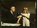
Everyday school life: The doctor Dr. Schreiber gives an injection to a schoolgirl

School class

Classroom. Background: posters for drawing war bonds

Schoolchildren in San Augustine
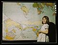
Schoolgirl in front of world map

.jpg)


Individual evidence
- ↑ a b c d e f g h i j k l m n o San Augustine County . Vista K. McCroskey, Texas State Historical Association (TSHA), June 15, 2010 (Engl.)
- ↑ See map image on Google Maps and county map (PDF) in the portal of the Texas State Historical Association (TSHA); accessed on October 24, 2018
- ^ San Augustine, Texas . weatherbase.com, accessed October 24, 2018
- ↑ Davy In East Texas . Bob Bowman, Texas Escape, Aug. 30, 2009
- ↑ The number of volunteers who moved to the Alamo with Davy Crockett varies between 12 and 14. In its description of the Battle of Alamo, Geo magazine gives the number of 14 grenadiers (excluding Crockett himself). See: "Remember the Alamo" . Marion Hombach, GEO No. 68: The Wild West, August 2014
- ^ A b Residents aspire to save San Augustine . Richard Stewart, Houston Chronicle, April 8, 2001
- ^ What's a Texas town without a Dairy Queen? . Emily Foxhall, Houston Chronicle, accessed October 24, 2018
- ↑ An old East Texas town looks to the future through the prism of its past . Joe Holley, Houston Chronicle, Oct. 20, 2017.
- ^ A b Population of San Augustine County . Data on Population.us, accessed October 24, 2018.
- ↑ San Augustine County, Texas , ACS Demographid and Housing Estimates 2012-2016, American Fact Finder, accessed October 24, 2018.
- ↑ a b San Augustine County, Texas , summary on the United States Census Bureau website, accessed October 24, 2018.
- ^ Household Income in San Augustine County, Texas . Overview of household income on Statisticalatlas.com, accessed October 24, 2018 (Engl.)
- ↑ a b 2016 Presidential General Election Results . Interactive map on USElectionatlas.org, results accessed October 24, 2018.
- ^ US Congressman Louie Gohmert . Louie Gohmert's MP website, accessed October 24, 2018
- ↑ Louie Gohmert . Info page at ballotpedia.org, accessed on October 24, 2018 (Engl.)
- ^ Profiles on the Right: Louie Gohmert . Matthew Parkes, Political Research Associates, Jan. 2, 2014
- ↑ San Augustine Counry, TX . Map with districts on the county's homepage, accessed October 24, 2018 (PDF)
- ^ San Augustine County / Sheriff . San Augustine County Web Site, accessed October 24, 2018
- ↑ Overview of San Augustine County, Texas , statisticalatlas.com, accessed October 28, 2018.
- ^ A b San Augustine County / Community Development . San Augustine County Web Site, accessed October 24, 2018
- ↑ For the individual industries and corporate sectors, see Industries in San Augustine County, Texas and Sectors in San Augustine County, Texas . Both: statisticalatlas.com, accessed October 24, 2018
- ↑ Sam Rayburn Lake . sam-rayburn-lake.com, accessed October 24, 2018 (Engl.)
- ↑ Trip Guide: Angelina National Forest . Courtney Bond, Texas Monthly, May 2, 2014
- ↑ Jim Foster: Birds Trails Texas - Panhandle and Prairies and Pineywoods. Sandhill Crane Press, Belgrade (Montana) 2011 (Engl.), P. 134. Excerpts online at Google Books .
- ^ National Register of Historic Places / Texas - San Augustine County . nationalregisterofhistoricplaces.com, accessed on October 24, 2018 (Engl.)
- ^ San Augustine County's 24th Annual Sassafras Festival . Information about the 2014 festival on texasforesttrail.com, October 25, 2014 (Engl.)
- ^ Farm Security Administration / Office of War Information Color Photographs . Library of Congress, accessed October 24, 2018
Web links
- Official Homepage of the San Augustine County (Engl.)
- San Augustine County in Handbook of Texas (Engl.)
- "San Augustine County Profile" of the Texas Association of Counties (Engl.)
List of counties in Texas
Anderson |
Andrews |
Angelina |
Aransas |
Archer |
Armstrong |
Atascosa |
Austin |
Bailey |
Bandera |
Bastrop |
Baylor |
Bee |
Bell |
Bexar |
Blanco |
Borden |
Bosque |
Bowie |
Brazoria |
Brazos |
Brewster |
Briscoe |
Brooks |
Brown |
Burleson |
Burnet |
Caldwell |
Calhoun |
Callahan |
Cameron |
Camp |
Carson |
Cass |
Castro |
Chambers |
Cherokee |
Childress |
Clay |
Cochran |
Coke |
Coleman |
Collin |
Collingsworth |
Colorado |
Comal |
Comanche |
Concho |
Cooke |
Coryell |
Cottle |
Crane |
Crockett |
Crosby |
Culberson |
Dallam |
Dallas |
Dawson |
Deaf Smith |
Delta |
Denton |
DeWitt |
Dickens |
Dimmit |
Donley |
Duval |
Eastland |
Ector |
Edwards |
El Paso |
Ellis |
Erath |
If |
Fannin |
Fayette |
Fisher |
Floyd |
Foard |
Fort Bend |
Franklin |
Freestone |
Frio |
Gaines |
Galveston |
Garza |
Gillespie |
Glasscock |
Goliad |
Gonzales |
Gray |
Grayson |
Gregg |
Grimes |
Guadalupe |
Hale |
Hall |
Hamilton |
Hansford |
Hardeman |
Hardin |
Harris |
Harrison |
Hartley |
Haskell |
Hays |
Hemphill |
Henderson |
Hidalgo |
Hill |
Hockley |
Hood |
Hopkins |
Houston |
Howard |
Hudspeth |
Hunt |
Hutchinson |
Irion |
Jack |
Jackson |
Jasper |
Jeff Davis |
Jefferson |
Jim Hogg |
Jim Wells |
Johnson |
Jones |
Karnes |
Kaufman |
Kendall |
Kenedy |
Kent |
Kerr |
Kimble |
King |
Kinney |
Kleberg |
Knox |
La Salle |
Lamar |
Lamb |
Lampasas |
Lavaca |
Lee |
Leon |
Liberty |
Limestone |
Lipscomb |
Live Oak |
Llano |
Loving |
Lubbock |
Lynn |
Madison |
Marion |
Martin |
Mason |
Matagorda |
Maverick |
McCulloch |
McLennan |
McMullen |
Medina |
Menard |
Midland |
Milam |
Mills |
Mitchell |
Montague |
Montgomery |
Moors |
Morris |
Motley |
Nacogdoches |
Navarro |
Newton |
Nolan |
Nueces |
Ochiltree |
Oldham |
Orange |
Palo Pinto |
Panola |
Parker |
Parmer |
Pecos |
Polk |
Potter |
Presidio |
Rains |
Randall |
Reagan |
Real |
Red River |
Reeves |
Refugio |
Roberts |
Robertson |
Rockwall |
Runnels |
Rusk |
Sabine |
San Augustine |
San Jacinto |
San Patricio |
San Saba |
Schleicher |
Scurry |
Shackelford |
Shelby |
Sherman |
Smith |
Somervell |
Rigid |
Stephens |
Sterling |
Stonewall |
Sutton |
Swisher |
Tarrant |
Taylor |
Terrell |
Terry |
Throckmorton |
Titus |
Tom Green |
Travis |
Trinity |
Tyler |
Upshur |
Upton |
Uvalde |
Val Verde |
Van Zandt |
Victoria |
Walker |
Catfish |
Ward |
Washington |
Webb |
Wharton |
Wheeler |
Wichita |
Wilbarger |
Willacy |
Williamson |
Wilson |
Winkler |
Wise |
Wood |
Yoakum |
Young |
Zapata |
Zavala
Coordinates: 31 ° 24 ′ N , 94 ° 11 ′ W