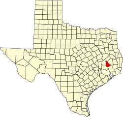
San Jacinto County
 San Jacinto Courthouse in Coldspring |
|
| administration | |
|---|---|
| US state : | Texas |
| Administrative headquarters : | Cold spring |
| Address of the administrative headquarters: |
San Jacinto County Courthouse P.O. Box 669 Coldspring, TX 77331-0669 |
| Foundation : | 1870 |
| Made up from: |
Polk County Liberty County Montgomery County Walker County |
| Area code : | 001 936 |
| Demographics | |
| Residents : | 26,384 (2010) |
| Population density : | 17.9 inhabitants / km 2 |
| geography | |
| Total area : | 1626 km² |
| Water surface : | 148 km² |
| map | |
| Website : www.co.san-jacinto.tx.us | |
The San Jacinto County is a county in the state of Texas of the United States . The county seat is in Coldspring . The county is part of the Sam Houston National Forest .
geography
The county is located in east Texas, about 90 km west of Louisiana . The Gulf of Mexico is about 80 km to the south. It belongs to the Houston-Sugar Land-Baytown Metropolitan Area and has an area of 1626 square kilometers, of which 148 square kilometers are water. It is bordered clockwise by the following counties: Trinity County , Polk County , Liberty County , Montgomery County, and Walker County .
history
San Jacinto County was formed in 1870 from parts of Liberty County, Montgomery County, Polk County, and Walker County. It was named after the Battle of San Jacinto , which brought Texas independence from Mexico .
Demographic data
| growth of population | |||
|---|---|---|---|
| Census | Residents | ± in% | |
| 1880 | 6186 | - | |
| 1890 | 7360 | 19% | |
| 1900 | 10,277 | 39.6% | |
| 1910 | 9542 | -7.2% | |
| 1920 | 9867 | 3.4% | |
| 1930 | 9711 | -1.6% | |
| 1940 | 9056 | -6.7% | |
| 1950 | 7172 | -20.8% | |
| 1960 | 6153 | -14.2% | |
| 1970 | 6702 | 8.9% | |
| 1980 | 11,434 | 70.6% | |
| 1990 | 16,372 | 43.2% | |
| 2000 | 22,246 | 35.9% | |
| 2010 | 26,384 | 18.6% | |
| 1850-2010 | |||
According to the 2000 census , San Jacinto County had 22,246 people in 8,651 households and 6,401 families. The population density was 15 people per square kilometer. The racial the population was composed of 83.64 percent white, 12.64 percent African American, 0.46 percent Native American, 0.28 percent Asian, 0.07 percent of residents from the Pacific island area and 1.63 percent from other ethnic groups Groups; 1.28 percent were descended from two or more races. 4.87 percent of the population were Hispanic or Latino of any race.

Age pyramid of San Jacinto County (as of 2000)
|
Of the 8,651 households, 30.0 percent had children or young people living with them. 60.2 percent were married couples living together, 9.7 percent were single mothers and 26.0 percent were non-families. 22.6 percent were single households and 10.1 percent had people aged 65 years or over. The average household size was 2.55 and the average family size was 2.98 people.
25.2 percent of the population was under 18 years old, 7.4 percent between 18 and 24, 24.9 percent between 25 and 44, 26.6 percent between 45 and 64 and 15.9 percent were 65 years of age or older. The average age was 40 years. For every 100 females there were 100.5 males and for every 100 females age 18 or over there were 97.4 males.
The median income for a household in the city is $ 32,220 , and the median income for a family is $ 37,781. Males had a median income of $ 34,614 versus $ 22,313 for females. The per capita income was $ 16,144. 15.1 percent of families and 18.8 percent of the population lived below the poverty line.
cities and communes
See also
Individual evidence
- ^ San Jacinto County in the Geographic Names Information System of the United States Geological Survey . Retrieved February 22, 2011
- ↑ Texas Almanac: Population History of Countys from 1850–2010 (PDF; 698 kB), accessed September 18, 2012
- ^ San Jacinto County, Texas , 2000 census data sheet at factfinder.census.gov .
Web links
Coordinates: 30 ° 35 ′ N , 96 ° 10 ′ W
