
Cameron County, Texas
 Cameron County Courthouse |
|
| administration | |
|---|---|
| US state : | Texas |
| Administrative headquarters : | Brownsville |
| Address of the administrative headquarters: |
Cameron County Courthouse P.O. Box 2178 Brownsville, TX 78522-2178 |
| Foundation : | 1848 |
| Made up from: | Nueces County |
| Area code : | 001 210 |
| Demographics | |
| Residents : | 406,220 (2010) |
| Population density : | 173.2 inhabitants / km 2 |
| geography | |
| Total area : | 3306 km² |
| Water surface : | 960 km² |
| map | |
 |
|
The Cameron County is a county in the US - State of Texas . Located between the Gulf of Mexico and the mouth of the Rio Grande , it is the southernmost county of Texas. The county seat is in Brownsville . In 2016, the county had 418,785 residents.
geography

_(16656628891).jpg)
The county is located in the extreme south of Texas, borders Mexico to the south and the Gulf of Mexico to the east. It has an area of 3306 square kilometers, of which 960 square kilometers are water. In the north it borders counterclockwise with the Texas counties Willacy County and Hidalgo Counties , in the south with Mexico and in the east with the Gulf of Mexico. Scenically, it is part of the region of South Texas. The most important landscape factors are the southern boundary river Rio Grande, which flows east of Brownsville into the Gulf of Mexico, and the Gulf coast itself. In front of the coast is the barrier island Padre Island , so that the actual coastal area is located within a lagoon . The soils in the near coastal area are sandy and salty with clay additives , those further inland are clay-colored loamy. The landscape is mostly flat: slight elevations can only be found in the western, inland part. The vegetation in the eastern area is determined by coastal saline prairies , the more inland by the more mixed vegetation of the Lower Rio Grande Valley .
The two most important centers of the county are the metropolis Brownsville (175,000 inhabitants), located directly on the Mexican border , and Harlingen (65,000 inhabitants) to the northwest . Other cities are La Feria , Los Fresnos , Palm Valley , Port Isabel , Rio Hondo and San Benito , towns with their own municipal administration (Towns) Bayview , Combes, Indian Lake, Laguna Vista, Los Indios , Primera, Rancho Viejo, Santa Rosa and South Padre Island . In addition, there are around two dozen municipalities combined purely for administrative purposes. Settlement centers are the two metropolitan areas of Brownsville and Harlingen. The majority of the cities and towns are north of Brownsville or along the US-281 in the valley of the Rio Grande. The US Highway 281 is one of the most important national links. Moreover, there is connection to the US Highway 83, the Texas State Highways 4, 48, 100, 107 and 345 and Interstate 69th
The weather in the region is subtropical- warm. The monthly average temperatures range between 15 ° C in winter and almost 30 ° C in the summer months of July and August. The water temperature is constantly above 20 ° C; The amount of precipitation varies between under 40 mm in winter and sometimes over 70 mm in summer. The rainiest month is September. The number of rainy days fluctuates between 2 and 6 and reaches its maximum in September with an average of 8. The temperatures and rainfall for the administrative center of Brownsville on the border with Mexico are as follows:
|
Monthly average temperatures and rainfall for Brownsville, Texas
|
|||||||||||||||||||||||||||||||||||||||||||||||||||||||||||||||||||||||||||||||||||||||||||||||||||||||||||||||||||||||||||||||||||||||||||||||||||||||||||||||||||||||||||||||||||||||||||||||||||
history
Until the end of the 19th century
.svg)
Before the arrival of the Spaniards in Mexico, different Indian tribes lived in the Gulf Coast region on both sides of the Rio Grando - partly from the Coahuiltec language group , partly from the Karankawa , whose tribal area stretched northward on the Gulf Coast to today's Galveston . Due to illness, their number had already decreased considerably in the 17th century . In 1638 the governor of Léon sent a first expedition to the area. The group under the leader Jacinto García de Sepulveda had the order to explore the region north of the Rio Grande. The expedition of the colonist Miguel de la Garza Falcón in 1747 gave more precise ideas about the local conditions. In 1765 the community of San Juan de los Esteros was founded south of the Rio Grande - the forerunner of today's border town of Matamoros . With the help of land allotments and financial subsidies, the viceroyalty of New Spain tried to lure more settlers into the region.


Regardless, the area was sparsely populated until the outbreak of the Texan Revolution . Even after the signing of the Treaty of Velasco, in which Mexico recognized the independence of the Republic of Texas , sovereignty over the area north of the Rio Grande remained in dispute. So far, Mexican had Ranch - landowners the the Mexican state of Tamaulipas scoring area as grazing land used. For this reason Mexico continued to claim supremacy there. Only the Mexican-American War between 1846 and 1848 brought a final clarification . As early as January 1846, a force under the command of General Zachary Taylor marched into the disputed territory between the Nueces River and the Rio Grande and set up an outpost - fort opposite Matamoros Texas. During the war the fort was renamed Fort Brown. During the war, the area of what will later become the county was the scene of three armed clashes: the battle of Las Rucias on April 25, 1846, the battle of Palo Alto (May 8, 1846) and the battle of Resaca de la Palma (May 9, 1846) .

With the signing of the Treaty of Guadalupe Hidalgo , the area became part of the United States. Just a few days later - on February 8, 1848 - Cameron County was founded. It was named after Ewen Cameron, an officer in the Republic of Texas Army. The first administrative seat was the town of Santa Rita, located near Fort Brown. After another vote in December 1848, however, the newly founded Brownsville , located immediately next to the fort , was designated as the county seat. Due to the situation, trade in particular became the determining force in the first few years. Brownsville acted on the one hand as a contact point to bring contraband goods over the Rio Grande, on the other hand as a base for the onward shipment of American goods up the river. The California gold discoveries of 1848 brought more settlers to the region. By 1850, the county's population had grown to 8,451. The early history of the district was largely determined by land disputes over the territory of long-established Spanish and Mexican landowners. The legal disputes over the validity of titles dragged on well into the second half of the 19th century .
During the American Civil War , the Confederation tried to take advantage of the county's location to break the naval blockade of the northern states . In 1864 federal troops briefly occupied the region; Confederate associations , however, managed to drive them out again. In May 1865, one of the final land battles of the war was fought in Cameron County - the Battle of Palmito Ranch. The economic upturn stagnated after the end of the war. A new railway line between San Antonio and Laredo diverted trade. A direct railway connection to the north was not completed until the beginning of the 20th century - the St. Louis, Brownsville and Mexico Railway , which went into operation in 1904 . The economy continued to be based on cattle breeding in the post-war decades - mostly operated by relatively wealthy landowners. Agriculture was another important factor . The initially promising cultivation of maize , cotton , vegetables and fruit stagnated temporarily in the 1880s, but picked up speed again with the new tried and tested irrigation systems .
Relations between the two main ethnic groups - whites and Latinos - were largely conflict-free until the 1880s and 1890s. As in the rest of the lower Rio Grande Valley, the two population groups were roughly equally strong. Intercultural marriages were widespread; likewise the adjustment of cultural preferences . The county's elites were also divided equally between Spanish-speaking mestizos and Anglos . The connection to the railway network to the north in 1904 triggered land speculation on a large scale. Newcomers from the north - sometimes brought in by special trains - bought cheap land . One effect was the commercialization of agriculture through new extensive irrigation systems, roads and the use of trucks . Economic change also changed the existing social structure. While the climate before 1900 was characterized by convergence and mutual respect , the new settlers from the Midwest and North brought separatist, demarcating forms of behavior with them to the south. Many of the newcomers viewed their Mexican neighbors as racially inferior. De facto segregation - separate churches , schools, and restaurants for Hispanics and Anglo-Americans - became more prevalent.
20th and 21st centuries
.jpg)

Tensions between the two main ethnic groups were heightened, among other things, by the aggressive action taken by ranchers and Texas Rangers units against cattle theft along the border. Under the command of Leander H. McNelly , the Texas Rangers had a special unit stationed in Cameron County as early as the 1870s. The subsequently established practice of chasing bandits across the Mexican border put a considerable strain on the relationship between the two states. The Mexican Revolution and the Wilson administration 's policy of non-recognition and strength demonstration further exacerbated the tense situation. In 1913, Wilson stationed a large force along the border. On February 24, 1913, the situation near Brownsville escalated in the form of minor border skirmishes. In April 1915, a reconnaissance flight started from the nearby Fort Brown army base with the aim of gaining knowledge about the strength of the associations of the north Mexican revolutionary leader Pancho Villa . In October 1915, bandits destroyed the railroad tracks north of Brownsville, derailed a train, robbed passengers and killed a soldier and two passengers. In 1916 General John Pershing started a large-scale punitive expedition against the Pancho Villa associations. American units with a strength of 10,000 men advanced into Mexican territory. However, the expedition did not achieve the set goal - the elimination of Villa. Due to the situation in Europe and the financial burdens, President Wilson ordered the end of military activities in 1917. Smaller skirmishes with Mexican irregulars continued until 1919.
The civil war in Mexico, which lasted more than a decade, and the large number of war refugees also changed the composition of the population in Cameron County. The population , which was around 16,000 in 1900, soared and doubled from over 36,000 to over 77,000 between 1920 and 1930. In the wake of the social upheavals after the turn of the century , the leading elite in Cameron County had also changed. The paternalistic system established by the Democrat James B. Wells , which was based on a balance of interests, was replaced by a new, largely non-local elite, which did not identify much with the growing culture within the region. During the Prohibition Period , Brownsville became a popular port of entry for illegal alcohol . In addition, the city became a point of contact for tourists who bypassed the alcohol ban by excursions to Matamoros, Mexico. The Great Depression slowed economic growth again. The port of Brownsville, completed in 1936, and the expansion of the acreage for commercial agriculture, however, cushioned the effects of the economic crisis. Between 1920 and 1930, the number of farms in Cameron County grew from 1,507 to 2,936; In 1940 their number was 3,243.
Cameron County was an important food production and export center during World War II. Agriculture continued to expand in the post-war years . Despite the decline in operating number , production volume rose further. The production of fossil fuels was another economic factor. The last traces of racial segregation were removed with the closure of separate schools for children of migrant workers in the 1970s. However, the later influx of refugees from Central and South America once again increased tensions in the region. The refugee problem was particularly pronounced in Harlingen, where several hundred refugees lived in a run-down hotel building and on the street in 1988 and early 1989 . Many poor Hispanics - especially newcomers from Mexico and Central America - live in ethnic enclaves and slums, many of which do not have electricity or running water . An additional problem was the fact that the Mexican drug cartels also developed increasing activity in the Brownsville-Matamoros border region. On the occasion of a six-hour shootout between members of the Gulf cartel and the Mexican military , the US authorities briefly closed the border in November 2010. A body find in the summer of the same year also attracted attention . Police found 15 bodies south of the border . Those previously tortured were draped with the letter "Z" - an indication of the perpetrators of the Zetas , a particularly brutal offshoot of the Gulf cartel.
The border installations also cause problems in everyday life - especially for those who live next door. 180 kilometers of the previously 1000 kilometers long wall , which covers a third of the border with Mexico, are in Texas. US President Trump's plans to significantly expand the border fortifications are being accepted rather resignedly by the border residents in the Brownsville region.
Demographics and Politics
| growth of population | |||
|---|---|---|---|
| Census | Residents | ± in% | |
| 1850 | 8541 | - | |
| 1860 | 6028 | -29.4% | |
| 1870 | 10,999 | 82.5% | |
| 1880 | 14,959 | 36% | |
| 1890 | 14,424 | -3.6% | |
| 1900 | 16,095 | 11.6% | |
| 1910 | 27,158 | 68.7% | |
| 1920 | 36,662 | 35% | |
| 1930 | 77,540 | 111.5% | |
| 1940 | 83.202 | 7.3% | |
| 1950 | 125,170 | 50.4% | |
| 1960 | 151,098 | 20.7% | |
| 1970 | 140.368 | -7.1% | |
| 1980 | 209.727 | 49.4% | |
| 1990 | 260.120 | 24% | |
| 2000 | 335.227 | 28.9% | |
| 2010 | 406.220 | 21.2% | |

In 1860 the number of inhabitants was only in the four-digit range, around 1900 it was around 16,000. Due, among other things, to the refugee movements during and after the Mexican Revolution, it doubled between 1920 and 1930 - from around 36,000 to around 77,000. Another significant increase occurred in the decades during and after World War II. Interrupted only by a brief decline in the 1960s, it rose from around 125,000 in 1950 to over 400,000 in 2010. The growth rates since the 1980s are due to the increased influx of retirees , according to the Texas Online Handbook . In a ranking of the most popular retirement homes , according to the Handbook article, the county was ranked seventh.
According to census of 2016 the population of the county was 418,785 people. 202,517 of them were male , 216,268 female . 286,191 inhabitants were older than 18 years, 132,594 inhabitants were children or adolescents , 51,812 inhabitants were older than 65 years. The determined median age of 31.3 years is well below that for the United States as a whole (37.7 years) and almost 3 years below that for all of Texas (34.2 years). The largest group of the population are the Latin Americans: Regardless of the question about the census declaration Race , 372,685 residents or 89% described themselves as Hispanic or Latino. The vast majority classified themselves as Mexicans; around 12,000 indicated a different origin. With 40,622 or 9.7%, whites are the second largest population group. 2,580 or 0.6% were Asian , 1,597 or 0.4% African American , 371 or 0.1% classified their ethnicity as North American Indians. 767 or 0.2% said they belonged to two or more ethnic groups.
According to Quickfacts information on census.gov , the median income per household was 34,578 US dollars (USD). In comparison, it was well below that of the state of Texas (US $ 51,900) and the United States as a whole (US $ 53,000). The census showed 29.1% of people living in poverty and 28.6% of people without health insurance . These values were also well above the US and federal benchmarks (12.7% and 11.7% and 15.6% and 19.3%, respectively). The results on ethnic composition, median household income and other indicators deviate significantly from the overall result in the smaller units city and town. The population of Bayview, northeast of Brownsville, is almost three-quarters white, employed in the technical and management sectors , and has a median household income above the US average. The tourist community of South Padre Island has a median age of 60 years. Cameron Park, a self-contained enclave in the Brownsville metropolitan area, is nearly 95% inhabited by Hispanics. The median household income is $ 25,300 and the median average age is 25.6 years.
Just like South Texas as a whole and the Rio Grande Valley in particular, Cameron County is a traditional stronghold of the Democratic Party . With the exception of the elections in 1848 , 1896 , 1952 , 1956 , 1972 and 1988 , Democratic presidential candidates always emerged victorious. This also applies to 2016 : While Donald Trump won the state with a clear majority of 52% (compared to 43% for Hillary Clinton ), in Cameron County 64.5% voted for Clinton and only 32% for Trump. Although Republicans have been up in national and state elections since the 1970s, Democrats are still ahead. This is especially true in local elections, where the party coped well with the end of the Wells era in the 1920s and continues to be present.
Economy and education


Thanks to improved irrigation systems, agriculture remains a determining factor in the county's economy. The range of agricultural products includes: corn , sugar cane , hay , soybeans , onions , cabbage , carrots , melons , peppers , cucumbers , tomatoes , grapefruits , oranges and pecans . Cattle and pig breeding are added as complementary sectors. A large part of the non-agricultural income comes from the processing of fruit and vegetables as well as fishery products. There is also light industry and the production of crude oil and natural gas . Another factor - especially in the coastal towns and cities - is tourism. Attracted by the mild climate and the comparatively low cost of living , thousands of visitors come, especially in the winter months. The border metropolis Brownsville also serves as the “gateway to Mexico” for tourists and shoppers.
The first schools in the county were established before the Civil War. One of the first was the Rio Grande Female Institute founded by Melinda Ranklin in 1852 . Other early schools were the Villa María girls 'school founded by Catholic nuns and the boys' counterpart, St. Joseph's Academy . By 1904, the number of schools in the county had grown to 59. Since less money was typically spent on schools for Hispanics, the quality of education there was generally poor. In the early 1990s, eleven school districts were present in the county with 60 elementary schools , thirteen middle schools , eleven high schools and three special schools. There were also various private schools with a total of around 4,000 students. An offshoot of the University of Texas-Pan American in Brownsville, located in Edinburgh in neighboring Hidalgo County, and the Texas State Technical Institute in Harlingen are added as institutions with college status . Despite the facilities in the county, the level of education was still considered relatively low in the 1990s - which is why many better educated young people moved away from the area.
Sights and culture


Brownsville and the county are home to a wide variety of attractions, recreation and cultural options. The most important are:
- Different protected areas for nature and landscape such as the Resaca De La Palma State Park between Brownsville and Rancho Viejo, the South Padre Island Birding and Nature Center and Padre Island National Seashore and the Brazos Island State Park on Padre Island, the Hugh Ramsey Nature Park in Harlingen, the Laguna Atascosa National Wildlife Refuge in Rio Hondo, the Las Palomas Wildlife Management Area in the Rio Grande Valley and the Boca Chica State Park north of the Rio Grande confluence with the sea.
- South Padre Island Dolphin Research & Sealife Nature Center , a dolphin refuge and marine animal center in Port Isabel.
- the Gravity Park - an amusement park on Padre Island.
- the Gladys Porter Zoo in Brownsville.
- Palo Alto Battlefield National Historical Park - a memorial to the memory of the Battle of Palo Alto.
- Golf courses : the Rancho Viejo Country Club in Rancho Viejo and the South Padre Island Golf Club on the island of the same name.
- Museums : Brownsville is home to the two facilities, the Historic Brownsville Museum , the Children's Museum of Brownsville , the Brownsville Heritage Museum, and the Stillman House Museum . The Historic Brownsville Museum is housed in the former depot of the Southern Pacific Railroad , a functional building that was shut down in 1952 and built in the Spanish colonial style. Harlingen, a city shaped by its past as an army base, is home to the Arts & Heritage Museum, the Performing Arts Theater, the Iwo Jima Memorial Museum and the Iwo Jima Memorial Monument .
- Theaters : In Brownsville you will find: the Jacob Brown Auditorium, The Arts Center and the Camille Lightner Playhouse .
- Festivals and Parades : Brownsville hosts the Latin Jazz Festival annually in October . On July 4th, the city hosts an Independence Day parade .
- The entries on the National Register of Historic Places are mostly concentrated in the district capital Brownsville. The register lists 22 entries for the city - including the no longer used Cameron Court House and the site of the former Fort Brown . The Port Isabel lighthouse is listed as a Historic Place .
- There are four National Historic Landmark sites in Cameron County : Fort Brown , Palmito Ranch Battlefield , Palo Alto Battlefield and Resaca de la Palma Battlefield .
Almost all of the famous people in the county are from Brownsville. These include: longtime Democratic Congresswoman Grace Napolitano (who did her political career in California ), science fiction writer Bruce Sterling, and country musician Kris Kristofferson . The Michigan- born rock 'n' roll musician Bill Haley does not come from the county . However, Haley spent his old age on his estate in Harlingen - where he moved in 1977 and died on February 9, 1981.
Others
Cameron County is home to most of the United States' ocelot population. This is the subspecies L. p. albescens , which is found only in southern Texas and northeastern Mexico and whose total population is estimated to be less than 250 animals. Traffic accidents are the main threat to this subspecies today. As a protective measure, in Cameron County, for example, the embankments along irrigation ditches are no longer mowed. This increases the maintenance and maintenance costs of these moats. For the ocelot, however, this is intended to create significant game passes .
Places in Cameron County
Cameron County is divided into 18 parishes, including 8 cities , 9 towns and one village . For statistical purposes, the US Census Bureau maintains 34 census-designated places . These have no self-administration.
Census-designated places (CDP)
gallery
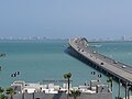
Connection between the mainland and the barrier island of South Padre Island

Downtown Brownsville

Palo Alto Memorial Park

Brownsville Kitchen (circa 1933)
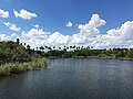
Delta landscape near Brownsville
Sabal Palm Nature Reserve
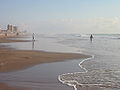
Beach at South Padre Island

Rio Grande between Matamoros and Brownsville

Gateway International Bridge in Brownsville


_(16664485285).jpg)


Individual evidence
- ↑ a b c d e f g h i j k l m Cameron County . Alicia A. Garza / Christopher Long, Texas State Historical Association, June 12, 2010 (Eng.)
- ↑ Overview of Cameron County, Texas . statisticalatlas.com, accessed January 12, 2018
- ↑ Charles Curry Aiken, Joseph Nathan Kane: The American Counties: Origins of County Names, Dates of Creation, Area, and Population Data, 1950-2010 . 6th edition. Scarecrow Press, Lanham 2013, ISBN 978-0-8108-8762-6 , p. 42 .
- ↑ Jay Robert Nash: Encyclopedia of Western Lawmen & Outlaws . Da Capo Press, Boston 1994, ISBN 978-0-306-80591-2 , pp. 205/206 and 224; excerpts online at Google Books (Engl.)
- ↑ Mexican Eypedition . GlobalSecurity.org, accessed January 12, 2018
- ^ War against the Mafia in Mexico: drug lord dies in a hail of bullets . Cecibel Romero, daily newspaper, November 7, 2010
- ^ Mafia: Mexican army kills drug lord Coronel . Zeit Online, June 30, 2010
- ↑ Life behind the border fence . Deutschlandfunk Kultur, November 1, 2012
- ↑ Border between the USA and Mexico: election campaign meets reality . Andreas Horchler, tagesschau.de, March 7, 2017
- ↑ a b Population of Cameron County . Data on population.us, accessed on January 12, 2018
- ^ Cameron County, Texas . ACS Demographic and Housing Estimates, 2016, American FactFinder, accessed January 12, 2018
- ↑ a b Cameron County, Texas , summary on the website of the United States Census Bureau, accessed January 12, 2018.
- ^ Household Income in Cameron County, Texas . Household income overview on statisticalatlas.com, accessed January 11, 2018
- ↑ Listed data on Bayview, South Padre Island and Cameron Park on: American FactFinder (ethnic composition Bayview), statisticalatlas.com (employment sectors Bayview), statisticalatlas.com (median income Bayview), American FactFinder (age median South Padre Island), statisticalatlas.com (Cameron Park median income) and American FactFinder (Cameron Park ethnicity and median age); accessed on January 12, 2018
- ↑ 2016 Presidential General Election Results . Interactive map on useclectionatlas.org, results accessed on January 11, 2018
- ^ The Ballad of Brownsville . Gene Fowler, Texas Highways - The Travel Magazine of Texas, November 2014 (Eng.)
- ↑ Listing of National Historic Landmarks by State: Texas . National Park Service , accessed January 25, 2018.
- ^ Pioneer Haley almost forgotten in Harlingen . Bruce Lee Smith, Valley Morning Star, February 6, 2009
- ↑ Mel Sunquist and Fiona Sunquist: Wild Cats of the World . The University of Chicago Press, Chicago 2002, ISBN 0-226-77999-8 , p. 125
Web links
List of counties in Texas
Anderson |
Andrews |
Angelina |
Aransas |
Archer |
Armstrong |
Atascosa |
Austin |
Bailey |
Bandera |
Bastrop |
Baylor |
Bee |
Bell |
Bexar |
Blanco |
Borden |
Bosque |
Bowie |
Brazoria |
Brazos |
Brewster |
Briscoe |
Brooks |
Brown |
Burleson |
Burnet |
Caldwell |
Calhoun |
Callahan |
Cameron |
Camp |
Carson |
Cass |
Castro |
Chambers |
Cherokee |
Childress |
Clay |
Cochran |
Coke |
Coleman |
Collin |
Collingsworth |
Colorado |
Comal |
Comanche |
Concho |
Cooke |
Coryell |
Cottle |
Crane |
Crockett |
Crosby |
Culberson |
Dallam |
Dallas |
Dawson |
Deaf Smith |
Delta |
Denton |
DeWitt |
Dickens |
Dimmit |
Donley |
Duval |
Eastland |
Ector |
Edwards |
El Paso |
Ellis |
Erath |
If |
Fannin |
Fayette |
Fisher |
Floyd |
Foard |
Fort Bend |
Franklin |
Freestone |
Frio |
Gaines |
Galveston |
Garza |
Gillespie |
Glasscock |
Goliad |
Gonzales |
Gray |
Grayson |
Gregg |
Grimes |
Guadalupe |
Hale |
Hall |
Hamilton |
Hansford |
Hardeman |
Hardin |
Harris |
Harrison |
Hartley |
Haskell |
Hays |
Hemphill |
Henderson |
Hidalgo |
Hill |
Hockley |
Hood |
Hopkins |
Houston |
Howard |
Hudspeth |
Hunt |
Hutchinson |
Irion |
Jack |
Jackson |
Jasper |
Jeff Davis |
Jefferson |
Jim Hogg |
Jim Wells |
Johnson |
Jones |
Karnes |
Kaufman |
Kendall |
Kenedy |
Kent |
Kerr |
Kimble |
King |
Kinney |
Kleberg |
Knox |
La Salle |
Lamar |
Lamb |
Lampasas |
Lavaca |
Lee |
Leon |
Liberty |
Limestone |
Lipscomb |
Live Oak |
Llano |
Loving |
Lubbock |
Lynn |
Madison |
Marion |
Martin |
Mason |
Matagorda |
Maverick |
McCulloch |
McLennan |
McMullen |
Medina |
Menard |
Midland |
Milam |
Mills |
Mitchell |
Montague |
Montgomery |
Moors |
Morris |
Motley |
Nacogdoches |
Navarro |
Newton |
Nolan |
Nueces |
Ochiltree |
Oldham |
Orange |
Palo Pinto |
Panola |
Parker |
Parmer |
Pecos |
Polk |
Potter |
Presidio |
Rains |
Randall |
Reagan |
Real |
Red River |
Reeves |
Refugio |
Roberts |
Robertson |
Rockwall |
Runnels |
Rusk |
Sabine |
San Augustine |
San Jacinto |
San Patricio |
San Saba |
Schleicher |
Scurry |
Shackelford |
Shelby |
Sherman |
Smith |
Somervell |
Rigid |
Stephens |
Sterling |
Stonewall |
Sutton |
Swisher |
Tarrant |
Taylor |
Terrell |
Terry |
Throckmorton |
Titus |
Tom Green |
Travis |
Trinity |
Tyler |
Upshur |
Upton |
Uvalde |
Val Verde |
Van Zandt |
Victoria |
Walker |
Catfish |
Ward |
Washington |
Webb |
Wharton |
Wheeler |
Wichita |
Wilbarger |
Willacy |
Williamson |
Wilson |
Winkler |
Wise |
Wood |
Yoakum |
Young |
Zapata |
Zavala