
Rio Grande Valley

The Rio Grande Valley - also called The Valley or El Valle by its residents or abbreviated RGV - is a scenic-demographic region in the southernmost tip of the US state Texas . It is located on the northern bank of the Rio Grande , which forms the border between Mexico and the United States to El Paso . The four counties Cameron , Hidalgo , Starr and Willacy are commonly assigned to the region . Demographically, it is one of the fastest growing regions in the United States: From 1969 to 2014, the population grew from 325,000 to 1,300,000 residents. The Hispanic population is around 90%. Economically, the region is still strongly characterized by agriculture - especially the cultivation of vegetables and citrus fruits . The largest cities - Brownsville , Harlingen , McAllen , Edinburg and Mission - are concentrated in the southern part of the area near the Rio Grande and in the two counties of Cameron and Hidalgo.
Both historically and culturally , the Rio Grande Valley differs considerably from the rest of Texas - especially the regions of the state that are not part of southern Dtexas. Historically, the Valley was part of that southern Texas territory that only became part of the United States with the Mexican-American War in 1846. Culturally it is strongly influenced by the Hispanic majority of the population, politically and socially by the close border with Mexico as well as a strong, also geographically expressed gap between prosperity and poverty . In the area of popular culture , it has also produced its own, strongly regionally colored lifestyle .
Geography and climate
definition


_(16656997452).jpg)
The definition of the term Rio Grande Valley (to distinguish it from the middle and upper Rio Grande Valley also common here: Lower Rio Grande Valley) depends on whether it wants to emphasize more scenic or more culturally , politically and demographic features. The four counties Cameron, Willacy, Hidalgo and Starr are commonly assigned to the Valley . The first three form the regional political association Lower Rio Grande Valley Development Council . The fourth county, counted as "Valley", however - Starr - belongs to the South Texas regional union to the west of it .
Geographically and scenically, the Rio Grande Valley is determined by the Rio Grande. The border river, which is also the dominant river in the Greater Region, flows into the Gulf of Mexico east of Brownsville and the Mexican Matamoros . Geologically , in terms of the general landscape and vegetation , the region is structured differently. The oldest geological terrain is in inland Starr County; it developed between the Pliocene and the Oligocene . The landscapes of the other three counties, on the other hand, did not emerge until the Quaternary - a few million years ago. The current coastline is even more recent - essentially a few thousand years . In terms of landscape, the valley is divided into four zones: the Coastal Saline Prairies in the immediate Gulf Coast areas , the actual Lower Rio Grande Valley with the river delta of the Rio Grande as the center and the Central and Western Rio Grande Plain . The latter two regions are foothills of the southern plains and occupy large parts of Starr County and the northern part of Hidalgo County.
As a regional subdivision within Texas, the Rio Grande Valley only includes the parts of the lower Rio Grande Valley on the US side. Politically, economically , demographically and culturally there are numerous connections and similarities with the areas south of the river belonging to the Mexican state of Tamaulipas . With Matamoros (almost 450,000 inhabitants) and Reynosa (approx. 600,000 inhabitants) a little further inland, the two largest cities of Tamaulipas border directly on the valley. Just like San Diego and Tijuana in California as well as El Paso and Ciudad Juarez in the middle section of the American-Mexican border , the opposing border towns Brownsville and Matamoros are quasi siblings in the border region, optionally known as Border or Frontera .
Landscape features


The Rio Grande Valley extends from the Gulf Coast around 160 km inland over an area of 4,316 square kilometers. By far the most important river is the Rio Grande. The river basin of the Nueces River is also relevant in terms of drainage . Other rivers on the US side are the Arroyo Colorado, which runs parallel to the Rio Grande, and the Los Olmos Creek, which flows into the Rio Grande near Rio Grande City . Artificial waterways are a shipping canal leading to the Port of Brownsville and the Harlingen Channel, a junction of the Arroyo Colorado.
The landscape in the Rio Grande Valley is flat. The altitudes range from a few meters above sea level to 180 meters in the northern part of the Starr County. The eastern, auförmige part of the side and bayous dominated the Rio Grande estuary delta. The dominant landscape here is a mixture of coastal prairie and forest . Due to its location close to the tropics , there are numerous tropical plants such as flame trees , Cuban royal palms and coconut palms . The tracts of land lying directly on the coast and the offshore island of South Padre Island are part of the Coast Saline Prairies - a strip of land stretching from the Rio Grande estuary to north of Galveston .
Overall, the part of the region located directly on the Rio Grande has rich, fertile clay soils . Since the introduction of irrigation systems and the establishment of a railway connection , this part has been considered the heart of Texan vegetable growing. The northern parts of the region further away from the river, on the other hand, are part of the southern Texas Plains landscape. The sandy , dry, clay soils in this part of the valley are less suitable for agriculture and have traditionally been used for raising livestock . The immediate Gulf Coast area with the offshore islands of South Padre Island and Padre Island forms its own vegetation zone . Partly swampy saline prairies determine the picture here. In addition, the coastal areas are retreats for numerous animal species .
Significant deposits of crude oil and natural gas are mainly located in the two inland counties of Hidalgo and Starr. Starr County also has considerable deposits of lignite .
Flora and fauna

.JPG)
The Rio Grande Valley is the only ecoregion in the United States that is located in the subtropics. The contrast between the Chihuahua Desert in the west, the northern Mexican chaparral vegetation zone, the coastal plain on the Gulf and the subtropical forests along the Rio Grande favored the emergence of particularly species-rich flora and fauna . Before they were settled, the four counties of Cameron, Willacy, Hidalgo and Starr comprised extensive forests of Mexican bald cypresses and sabal palms . Deforestation, the introduction of commercial agriculture and the introduction of competing grasses from Africa not only displaced native plant species. Many animal species (once) native to the Valley are either endangered or threatened with extinction.
In order to preserve the existing flora and fauna at least in the main, different types of landscape protection areas were set up on the Gulf coast, in the river delta and along the Rio Grande (for details: see section “Tourist offers and sights”). Typical for the Valley plants are among the guaiac (a subtropical species), yucca (palmate growths, known under the terms yucca or - misleadingly - yucca), Spanish moss (a lichen-like plant which mainly in the lowland forests of river deltas can be found) as well as honey mesquite and prickly pears . The latter occur mainly in the saline prairie zones in the immediate vicinity of the Gulf Coast. Typical types of flowers for the valley are acanthus family , ice plant family , frog-spoon family and umbelliferae . In addition, there are different varieties of cactus plants in the region .
Above all, the bird life in the Rio Grande Valley is known for its extraordinary diversity. Native to the coastal zone are different types of gulls and terns , geese , water and coastal birds, common loon , Least Grebe , White Pelican , brown pelicans and sandhill cranes . Other bird species are the ear shag , the American darter , the magnificent frigate , from the heron family, among others, the American bittern and the North American bittern , from the order of birds of prey, among other things, osprey , swallow harrier and desert buzzards . The Atlantic hybrid turtle can also be found on the coast . In the vicinity of the river there are also numerous dragonflies and butterfly species - from the family of the knightly butterflies , the white flies , the blue flies and the noble butterflies, among others . A better known but critically endangered big cat is the ocelot . Also to be found in the valley are specimens of the jaguarundi - a type of cat also known as the weasel cat, which is also threatened with extinction. The region is also home to a wide range of different frog , snake and insect species .
| City | county | E. |
|---|---|---|
| Raymondville | Willacy | 11,165 |
| Brownsville | Cameron | 182.110 |
| Harlingen | Cameron | 65,634 |
| Edinburgh | Hidalgo | 84,399 |
| McAllen | Hidalgo | 138,475 |
| Hidalgo | Hidalgo | 13,449 |
| mission | Hidalgo | 82,200 |
| Pharr | Hidalgo | 75.172 |
| Weslaco | Hidalgo | 39,021 |
| Alamo | Hidalgo | 19,021 |
| Alton | Hidalgo | 15,581 |
| donna | Hidalgo | 16,349 |
| Mercedes | Hidalgo | 16,501 |
| San Juan | Hidalgo | 35,983 |
| Rio Grande City | Rigid | 14,242 |
| Roma | Rigid | 10.093 |
Infrastructure and traffic

The administrative-political outlines of the four counties belonging to the Valley emerged in several historical spurts. Until the start of the American-Mexican War, Mexico and Texas claimed the area equally. The first US county to be occupied by US troops was Nueces County (1846). In 1848 the two counties Starr and Hidalgo were separated from Nueces. Compared to their current size, both initially extended far into their northern surroundings. In 1852 Hidalgo was split off from Cameron, and in 1858 Starr was split into the eastern entity Starr and the western Zapata . In 1911, the northern portions of Cameron, Hidalgo and Starr were added to Brooks and Willacy Counties . The territory of the youngest Rio Grande Valley County - Willacy - was completely reconstituted in 1921: as another split from Cameron County, south of the original Willacy County.
Most of the important cities within the region are lined up in a string of pearls along US Highway 83 . The largest are bundled into two statistical metropolitan areas : Brownsville and Harlingen in Cameron County and McAllen, Edinburgh and Mission in Hidalgo County . In addition to the three cities listed, the latter also includes the city of Pharr in the east of this metropolitan area . Along with the northern Mexican city of Reynosa is McAllen binational, also known Borderplex firmierende metropolitan area . Other important cities in the Rio Grande Valley are Rio Grande City, Roma , Raymondville , Weslaco and Hidalgo . The settlement structure is strongly determined by the requirements of agriculture and accordingly widely spread; More densely populated town centers or classic city downtowns can only be found in the half dozen larger centers. In addition to US Highway 83, important east-west connecting roads are US Highway 287 , which runs through the center of the region, and the north-south axis US Highway 77 .
The most important national rail traffic connection is a line of the Union Pacific . The route runs from Brownsville along the Gulf Coast north to the Galveston / Houston area . A shorter rail line starts from Brownsville and extends to Rio Grande City. Since the major US railroad companies mainly serve freight and the two midwest- west routes of the dominant passenger traffic provider Amtrak only serve intermediate points in north and central Texas, the Valley is not connected to the high-speed passenger traffic network. A high-speed link between Oklahoma and the Rio Grande Valley has been under discussion since 2016, but was not beyond the exploratory phase until early 2019. Important airports in the region are the Brownsville – Harlingen International Airport . Another national airport is located within the Metropolitan Statistical Area McAllen – Edinburgh – Mission.
In terms of direction, the connections to the Rio Grande Valley region are oriented towards three points:
- the East Texas centers along the Gulf Coast ( Corpus Christi , Galveston, Houston),
- the south Texas center of San Antonio ,
- the middle and upper Rio Grande valley with its end point El Paso.
The northern Mexican centers of Matamoros, Reynosa and Monterrey, some of which are in the immediate vicinity, are also binational points of orientation. The straight- line distances - calculated from the metropolis Brownsville in the southeastern Valley - are rounded: to Corpus Christi 200 km, to Houston 470 km, to San Antonio 400 km and to El Paso 1,100 km. The distance to the city of Laredo , located on the middle reaches of the Rio Grande, is 270 km, to the neighboring city of Matamoros to the south of the border around 10 km and to the north Mexican state metropolis of Monterrey around 300 km.
climate

The Rio Grande Valley is one of the southernmost areas in the continental United States; further south there is only a small strip in southern Florida . The coastal areas are characterized by their location directly on the Gulf and accordingly have a humid subtropical climate. Due to the southern location, it is comparatively warm in the region overall. In the summer months , the maximum temperatures are around 35 ° C. Frost and snow in winter are rather rare, but due to the unprotected continental location, they can result in outstanding weather events. In general, however, there are only occasional freezing temperatures during winter . Temperatures around freezing hardly occur on the coast; Temperatures around 8 ° C are the norm in the winter months. In Starr County further inland, the frost period lasts from December 15 to early January. The amount of precipitation varies depending on the proximity to the gulf. While the average annual rainfall in the coastal Counties Willacy and Cameron is 66 to 76 centimeters, it is 55 to 66 centimeters in Counties Hidalgo and Starr. The city of McAllen - located roughly in the geographic center - is representative of the entire valley in terms of weather.
|
Monthly average temperatures and rainfall for McAllen, Texas
Source: US climate data
|
|||||||||||||||||||||||||||||||||||||||||||||||||||||||||||||||||||||||||||
The proximity to the Gulf of Mexico makes the Rio Grande Valley a destination for hurricanes . Although it is not affected as often as other US Gulf Coast areas, a number of hurricanes have wreaked havoc over the past few decades. The two tropical storms Dolly (2008) and Alex (2010) recently caused floods , power outages and property damage . Severe weather in the Rio Grande Valley typically occurs in the spring months. Severe thunderstorms and tornadoes, such as those common in the northern part of Texas, are rare. Thunderstorms with hail and extreme thunderstorms do happen. Example: rain-related flash floods in Edinburgh and San Carlos on June 19, 2015.
history
New Spanish and Mexican Period (until 1848)

.svg)

According to general assumptions, Native American Indians lived in South Texas 11,000 years ago - first as hunters and gatherers , later as farmers . The predominant peoples in the region were the Coahuiltecs and the Karankawa . The first contacts with Spanish exploration expeditions took place in the 16th century . In 1519 Alonso Alvarez de Pineda explored the Gulf coastline towards Florida. In 1527 the conquest of Florida failed. The survivors of the Panfilo de Narvaez expedition led by Cabeza de Vaca made their way south in the following years - interrupted by years in Indian captivity . In 1554 a Spanish fleet was destroyed off South Padre Island. In the 17th century , too , the New Spanish expeditions into the region were more selective than sustainable. The two most important were those of Jacinto García de Sepulveda in 1638 and that of Alfonso de Leon in 1689.
The New Spanish administration only developed more serious interest in the northern regions in the 18th century - in response to the activities of other colonial competitors on the northern borders of the New Spanish Empire. The first settlement activities in the Rio Grande Valley began around the middle of the century. Despite a military expedition under Miguel de la Garza Falcón, whose report had classified the area as unsuitable for settlements, the Empresario José de Escandón founded the first four settlements in the region in 1749: Reynosa, Camargo, Mier and Revilla (today: Guerrero ). Matamoros was founded in 1765. In the second half of the 18th century, the northern side of the river was also increasingly developed. One of the earliest foundations here was the settlement of Roma Los Saenz (Starr County).
The legal framework for the settlement was land grants, which were granted by the New Spanish administration. At the end of the 18th century, around 3,500 Spanish colonists lived in the region. Contrary to customary practice, the land grants were not given to members of the New Spanish or Creole elite, but rather to all who were willing to accept the barren conditions in the northern border areas. Essentially, the new settlers were former soldiers and immigrants from the Canary Islands . Another group of settlers were missionaries who maintained a precarious network of small mission stations . Compared to the rigid social hierarchy in the New Spanish heartlands, that in the settlements on the Rio Grande was comparatively permeable. The rather informal social structure also made it possible for indigenous peons to gradually (and over several generations) rise to the Creole ranching elite.
In the early days of Spanish colonization in the 18th and early 19th centuries , the area was mainly used as pastureland . The inland areas came into the catchment area of western Indian tribes in the early 19th century - especially the Comanche , who had expanded their area of influence, the Comancheria , far south around the turn of the century. Another tribe that caused unrest in the border areas were the Lipan Apaches . The latter were increasingly pushed out of the Texan prairie areas and into the mountainous region of West Texas by the Comanches. In economic terms, the settlement region in the Rio Grande Valley was almost exclusively characterized by cattle breeding . A peculiarity of the extensive ranches or haciendas was the keeping of free-range cattle - a pre-form of the Texas Longhorns that became famous in the 19th century .
Even after Mexico gained independence , the region remained sparsely populated. In the course of the forced land allotments for Anglo-American settlers , however, the composition of the population changed decisively: in 1834, around 30,000 Anglo-Americans and 7,800 Mexicans lived in what is now Texas. Efforts by the Mexican government to resettle more Mexicans in Texas have not proved successful. Unlike the rest of Texas, which became an independent state in 1837 , the border area south of the Nueces River remained controversial and claimed by both Texas and Mexico until the outbreak of the American-Mexican War . The United States created facts in the immediate run-up to the war - by underlining its readiness for war against Mexico and by sending troops under General Zachary Taylor to the Rio Grande. Near the river, Taylor had the military post Fort Brown built - the fait accompli, the siege of which by Mexican groups from May 3rd to 9th 1846 initiated the armed conflict. The town of Brownsville, not far from the fort, was established in 1848 - the first Anglo-American settlement in the region.
1848 to 1890


Economically, the region had differentiated itself at the end of the American-Mexican War. In the inland areas, the livestock factor still dominated. The areas directly on the Rio Grande and in the river delta around the city of Brownsville also used their location for cross-border trade . The Old Military Road laid out by Zachary Taylor's troops (originally a military road and largely identical to today's US Highway 83 in terms of its course) developed into a popular thoroughfare for gold prospectors on their way to the gold fields in California and Arizona from 1849 onwards .
One consequence of the war caused by the new demarcation was the separation of the population on both sides of the border. Associated with this were legal disputes between Mexican old settlers and Anglo-American new settlers. An important trigger was the lack of legal certainty for land titles that came from the Mexican or New Spanish period. Anglo-American newcomers also quickly secured strategically important positions in cross-border trade. In 1860 the dispute culminated in the Cortina Troubles - a rebellion led by the landowner Juan Nepomuceno Cortina and finally crushed by Texas Rangers units.
After the American-Mexican War and the simultaneous accession of Texas to the United States, there was a large influx of immigrants into the new state - including large contingents of Germans and Czechs . Although the associated slavery typical of the southern states' social structure was firmly established in the core Texas cotton areas , support for the confederation within Texas was by no means straightforward. There was widespread sympathy for the cause of the Union, especially in the areas in western central Texas inhabited by Germans and in the Hispanic regions in southern Texas . During the civil war , the Rio Grande Delta became an important depot for the Confederation's cotton trade and the port of Matamoros became the most important supply port. In addition, the Rio Grande Valley was the site of the final battle of the US Civil War - the Battle of Palmito Ranch on May 5, 1865.
Until the end of the 19th century, the valley remained sparsely populated, rural and economically determined by cattle breeding and agriculture. Although the coexistence between the Hispanic majority of the population - the so-called Tejanos - and immigrant Anglo-Americans developed in the direction of mutual tolerance over time, the situation in the Rio Grande Valley counties remained conflictual even after the end of the civil war. One reason was the lack of infrastructural development in the area. The region's first railway line was a military line; moreover, it merely grazed the area. In 1872 a narrow-gauge line was added, which led from Brownsville to the nearby Gulf Coast town of Port Isabel .
Economic disparities also widened between the counties of the Valley. One factor was that residents of the inland areas felt neglected. This feeling of disadvantage was compounded by the fact that Hidalgo County was unable to benefit from the booming blockade trade in neighboring Cameron County. The unsafe situation has resulted, among other things, in a general increase in lawlessness . The bandit groups operating in the region , who had focused primarily on cattle theft, led to an official appeal to the central government to finally address the grievances. On April 2, 1875, Captain H. McNelly finally arrived with a Texas Ranger force in the region and took up the fight against the bandit mischief.
The soils in the Rio Grande Delta and in the lower valley of the river offered good conditions for further landscape use. However, the lack of connection to the external markets slowed down further development. After 1880 the economy stagnated in the economically leading Cameron County. The development was accompanied by a hardening of the political power relations - in concrete terms: the establishment of a network of influence for the Democratic Party , which covered all of South Texas and also led to sometimes violent conflicts in the Valley Counties of Cameron, Hidalgo and Starr. Here too, social contrasts formed the background ; Specifically: the conflict between the long -established elites represented by the Democrats and their clients on the one hand, and newcomers and marginalized business people on the other.
In the course of these disputes, the intra-ethnic balance of power also shifted . In Cameron County, the (Anglo-Saxon) families King, Kenedy and Brown became the leading large landowners. In Hidalgo County the power struggles between the networks of Democrats and opposition Republicans - represented here by Sheriff John Closner - culminated in a kind of coup, during which the opposition Republicans briefly proclaimed a "Republic of Hidalgo" and thus began to collect taxes of their own accord . In Starr County to the west, on the other hand, the old Hispanic elites were able to hold their own in some cases - although here too the political polarization continued into the 1920s and led to corresponding trench warfare. An event associated with the political development on the south side of the border was the so-called Garza War 1891 - an attempt by American Mexicans to influence the internal Mexican power struggles and to start a rebellion from US territory against the dictatorship of Porfirio Díaz .
1890 to 1950

.jpg)
The introduction of industrial agriculture fundamentally changed the economic situation in the Rio Grande Valley. Three factors in particular had a dynamic effect:
- the introduction of irrigation systems on a large scale (from 1898)
- the connection to the national railway network through the construction of new railway lines (from 1904)
- the introduction of truck agriculture including the associated transport chains (from 1920)
Taken together, the factors listed resulted in the Rio Grande Valley evolving from a marginal, remote region into a major agricultural center. The development of large-scale irrigation systems , initiated by resourceful individuals and interested landowners, was the starting signal for the intensive use of the fertile , but otherwise drought- affected soils near the Rio Grande. The onset in the decade to railway closed the region to the national railway system and subsequently led thousands of new settlers to the Rio Grande Valley. The railway companies were particularly aggressive when it came to the associated land sale : They bought large tracts of land in advance, divided them up into parcels and sold them to customers who they recruited elsewhere. Land prices rose accordingly . In Hidalgo County, for example, the price of 1 acre rose from 25 cents in 1903 to 50 US dollars in 1906 and up to 300 US dollars in 1910. The cycle of technical innovations was brought to a close through the introduction of truck farming. It not only made it possible to carry out the harvests more efficiently , but also improved the transport of agricultural products to national markets.
.jpg)
Between 1900 and 1920, numerous new settlers from the Midwest and investors from the east coast poured into the region. The disputes connected with the new development expressed themselves economically and culturally and ethnically. In economic terms, it expressed itself as a conflict between (mostly long-established, partly Hispanic) cattle breeders and (newly arrived, usually Anglo-Saxon) farmers. In Willacy County, this conflict was resolved by territorial reconstitution of the county, in the course of which the farmer-settled southern half of Cameron County was branched off and most of the original county territory was added to the northern Kenedy County .
The development was similar in Starr County, where the northern (ranching) part was newly constituted as Brooks County. One point of conflict that had repercussions throughout the region was the increasing ethnic separation of the counties affected. Unlike the Anglo newcomers before, the new farmers were unwilling to adapt to the Hispanic culture of the region. As a result, ethnically separated schools , residential areas and churches increasingly established themselves . This development was particularly pronounced in Hidalgo County, where the new settlers founded a number of ethnically segregated new cities such as Pharr and Weslaco.
Tensions between Anglo-Saxon new settlers and the Hispanic majority were exacerbated by refugee movements as a result of the Mexican Revolution and the region's temporary status as a deployment area for US forces in the wake of the Pershing operation in 1916/17. A parallel event was the so-called bandit war. The trigger was a bandit attack on a train of the St. Louis, Brownsville & Mexico Railroad on October 18, 1915. The bandit war of 1915/16, in which units of the Texas Rangers and army units from Pershing's expeditionary corps took part, was fought with great brutality and was under including a series of lynching of bystanders.
The mood on both sides of the border was additionally fueled by rumors of an alleged "San Diego Plan". The story was avidly spread by the US media, claiming that the Mexican government of Venustiano Carranza was planning to instigate a Hispanic popular uprising in the American Southwest . The tense relationship between the two border states over long periods of time sometimes had bizarre effects - for example for the municipality of Rio Rico, which had moved to the south side of the river as a result of the change in the course of the Rio Grande. The place, the legal situation of which was suddenly unclear, temporarily became a logistical connection point between local criminals and the Chicago mafia . Although it had been on the "Mexican" side of the river for some time, it was not until 1970 that the United States formally ceded it to Mexico.
In the 1940s, the commercial form of agriculture was fully established. In addition, there were processing industries, suppliers and marketing agencies. The main cultivation areas were (and are) vegetables, corn , cabbage , carrots , potatoes , beets , green beans , onions and cotton. Citrus fruits have become the most important cultivated plants. Commercial citrus cultivation was introduced in 1904 and persisted in 1949, 1951, 1961, 1983 and 1989 despite severe frost # frost periods . During World War II , the region served as an important agricultural food supply center. Since the end of the war, the so-called Wintertexans have increasingly developed into another economic factor - holidaymakers from the north as well as pensioners who were attracted to the region by the year-round mild climate. Crude oil, natural gas and lignite were added to this: especially in the westernmost district, Starr County, significant oil and natural gas deposits were discovered in the 1930s and mining began.
From 1950

(NRCS_Photo_Gallery).jpg)

.jpg)
The course of the Rio Grande also changed in the second half of the 20th century . In October 1953, US President Eisenhower and Mexican President Adolfo Ruiz Cortines inaugurated the Falcon Dam . The 338 square kilometer reservoir , bordering Starr County to the west , was created as a result of an agreement between the United States and Mexico to better coordinate water supply , agricultural irrigation, flood protection and water reserve use in the border regions. The Falcon Reservoir is administered by an authority maintained by both states - the International Boundary and Water Commission . The progressive containment of the Rio Grande led - together with the general drought in the region - not only to a significantly lower water volume of the river. The water exchange between the (water-rich) USA and (water-poor) Mexico has increasingly caused disputes since the turn of the millennium. The reason: Mexico's water debt due to non-compliance with delivery quantities - a volume which , according to the Washington Post , amounted to almost 500 billion liters in 2014.
The restrictive mechanisms of segregation that excluded the Hispanic majority persisted well into the second half of the 20th century. Over time, however, they were gradually weakened or eliminated by opposing tendencies. A counteracting factor was the increasingly influential Hispanic civil rights movement - a factor which in the early stages led to renewed ethnic conflicts. So one was in June 1966 Cotton Pickers - strike in Starr County with the active participation of the local sheriff's department knocked down - by means of the pre-accession of strikebreakers from Mexico. In 1971 the Pharr Riots caused a sensation - a riot in the city of the same name, which was triggered by racist attacks by the local police. In Cameron County, segregation has largely been leveled out due to increased activity by the Hispanic civil rights movement. The last traces of separated schools were removed in the 1970s. One consequence of the no longer existing ethnic separation is the growing number of Hispanics who have since moved to political office.
Since the 1980s there has been a new rapid increase in population. The trigger was, among other things, migration from the Central American countries affected by civil wars . As a result of the - legal and illegal - migration, the number of so-called Colonias in the Valley area increased sharply. These were settlements, some of which had already existed for a long time, were mostly built on an ad hoc basis and often lacked electricity and water. Particular spots of these settlements are in Cameron County the region around Harlingen. In 1986, there were 366 colonias in Hidalgo County. Unlike in other regions of Texas, where the grievances have been increasingly addressed since the 1980s, this development in the Valley was delayed for a long time. The remote, hidden location of many of these settlements was identified as a possible reason for this. In the late 1980s, grievances due to a lack of sanitary facilities caused a sensation - especially high rates of dysentery , hepatitis and tuberculosis .
Another problem associated with migration is the free trade zones established between Mexico and the USA and the maquiladoras operated there . For a long time, especially among critics, they had the reputation of being a fly-by-night sweatshop system that exploited impotent young Mexican women . From the 1980s onwards, US companies began to invest in this sector. For a long time, the focus was on supplier tasks for the automotive industry , but the second, current generation of maquila is increasingly using modern automation technology , just-in-time processes and quality management workflows. Regardless of the economic diversification that has taken place, the counties of the Rio Grande Valley are still considered poor. The problems are exacerbated by the construction of the border with Mexico along the Rio Grande. Up until 2011, the central part of the border in the Border Patrol area of Tucson / Arizona recorded the highest number of deaths due to failed migration attempts, this has now been exceeded in the Rio Grande Valley section (2012 and 2013: around 150 deaths each).
As a region close to the border, the area is also affected by the drug trafficking of the Mexican narco cartels - a factor whose effects keep making headlines. Texas Monthly magazine described in 1977 how cross-border marijuana smuggling became an economic factor in remote and notoriously poor Starr County. A particularly dramatic incident occurred in 2010 when Gulf Cartel commandos attacked the town of Mier, south of the border, and carried out exemplary executions there. Following threats from competing Zetas to come back and review the loyalty of the local people, a mass exodus began that also affected nearby towns in Starr County. The Roma – Los Saenz community was also directly affected by the fact that city dwellers were also killed in the Mier massacre.
The efforts of US President Donald Trump to expand the border fortifications in the direction of Mexico and to act more restrictively against illegal migration have also met with criticism in the region . Chad Richardson, a former historian at the University of Texas-Pan American , expressed the special situation on the border with these words: “International borders often create unusual situations. Few situations are more unusual than those on the southern end of the Texas-Mexico border. This region, which was often controversial in the past, has not emerged as either completely American or completely Mexican. "
Demographics and Politics
| census | Cameron | Hidalgo | Rigid | Willacy | total |
|---|---|---|---|---|---|
| 1850 | 8,541 | - | - | - | 8,541 |
| 1860 | 6,028 | 1,192 | 2.406 | - | 9,626 |
| 1870 | 10,999 | 2,387 | 4.154 | - | 17,540 |
| 1880 | 14,959 | 4,347 | 8,304 | - | 27,610 |
| 1890 | 14,424 | 6,534 | 10,749 | - | 31,707 |
| 1900 | 16,095 | 6,837 | 11,469 | - | 34,401 |
| 1910 | 27,158 | 13,728 | 13,151 | - | 54,037 |
| 1920 | 36,662 | 38.110 | 11,089 | - | 85,861 |
| 1930 | 77,540 | 77.004 | 11,409 | 10,499 | 176.452 |
| 1940 | 83.202 | 106.059 | 13,312 | 13,320 | 224,516 |
| 1950 | 125,170 | 160,446 | 13,948 | 20,920 | 320.484 |
| 1960 | 151,098 | 180.904 | 17,137 | 20,084 | 369.223 |
| 1970 | 140.368 | 181,535 | 17,707 | 15,570 | 355.180 |
| 1980 | 209.727 | 283.229 | 27,266 | 17,495 | 537.717 |
| 1990 | 260.120 | 383,545 | 40,518 | 17,705 | 701.888 |
| 2000 | 335.227 | 569.463 | 53,597 | 20,082 | 978.369 |
| 2010 | 406.220 | 774.769 | 60,968 | 22,134 | 1,264,091 |
Demographics

In the course of its history, the Rio Grande Valley region experienced two rapid population increases : the first occurred in the first half of the 20th century. During this period, the population of the initially three and from 1921 four counties increased from several 10,000 inhabitants to around 320,000. After a plateau in the two post-war decades, the number of inhabitants rose again sharply in the 1970s and 1980s - to around 700,000 inhabitants in 1990. The increases are still above average. The Texas Alamanac 2018 listed the two Valley counties - Hidalgo and Cameron - in the 7th and 13th place of the most populous counties in Texas.
The inland population distribution within the four districts is clearly unequal , especially taking into account the county area areas , which do not differ widely in terms of size . The calculations of the US census 2017 show a total population of 1,344,999 for the entire area. 839,539 of them live in Hidalgo County, 420,201 in Cameron County. The other two counties - Starr and Willacy - have 63,420 and 21,839 inhabitants, respectively, around a sixteenth of the total population.
Not only do significantly more than half of all valley residents live in Hidalgo County. Due to its high birthrate , the county was listed at 64th place in the US as early as 1982. However, Hidalgo did not advance to the most populous valley county until after 1930. Until then, this position was held by Cameron County to the east. The differences were even clearer in the 19th century. According to the US census, more than half of the Valley's residents lived in Cameron County in 1880 (just under 15,000 of a total of around 27,500).

According to the 2017 census figures, the total population of the four Valley Counties was broken down as follows: 656,676 of the total of 1,344,999 people were male , 688,323 female . 905,014 inhabitants were older than 18 years , 439,984 inhabitants were children or adolescents , 150,078 were older than 65 years. The median age interpolated from the four individual numbers is 29.8 years. Statistically the “youngest” county is Starr (28.8 years), followed by Hidalgo (28.9 years). The median age in Willacy County, at 33.4 years, is significantly higher than in the Rio Grande Valley as a whole, but below that of the State of Texas (34.3 years) and that of the United States (37.8 years).
As in South Texas as a whole, Hispanics and Latinos make up the lion's share of the population. According to the 2017 census figures, 1,228,161 inhabitants or 91.3% of the population belonged to this classification. With 97,397 or 7.2%, whites are the second largest group of the population. 10,738 inhabitants (0.8%) characterized themselves as Asians , 5,248 (0.4%) as Afro-American and 1,118 (0.1%) as North American Indians . Finally, 1,838 people (0.2%) stated that they belonged to more than two ethnic groups. There are also differences between the individual counties in terms of ethnic composition. In Starr County, Hispanics and Latinos are almost the only population group with 99.2%. In Willacy County, on the other hand, the white non-Hispanic population is 11.1%, significantly higher than in the other three counties.
The economic and social parameters of the 2017 census survey also showed clear differences between the four counties. The highest budget - median incomes were determined in the counties Cameron and Hidalgo (36,095 or 37,097 US dollars ), the lowest in Willacy County and Starr County (29,104 US dollars or 27,133). The comparative values for the state and the United States as a whole were $ 57,051 and $ 57,652, respectively. The four Valley Counties achieved significantly higher percentages for the factors poverty and non-existent health insurance. Statistically speaking, the values for people living in poverty were 31.4%, 28.9%, 28.8% and 33.4% for the four counties of Cameron, Hidalgo, Starr and Willacy. The values for Texas and the United States as a whole: 14.7% and 12.3%, respectively. The proportions of those without health insurance for the four counties were 29.5%, 29.7%, 28.2% and 22.8%. Values for Texas and the United States here: 18.2% and 10.5%.
politics

The Hispanic south of Texas is traditionally a stronghold of the Democratic Party - unlike the rest of the state, which has consistently favored Republican candidates in all presidential elections since 1980. In the four Rio Grande Valley counties, the results for democratic applicants are mostly above average, even for regional conditions. Only the 1972 presidential election was an exception: in three of the four Valley Countries, the majority of voters voted for the Republican Richard Nixon . Only in Starr County did Nixon's rival George McGovern receive over 60 percent of the vote. Texas-wide already an isolated highlight, this value was only exceeded by 85.7 percent in Duval County - a district further north, which is also part of the South Texas region, which is largely inhabited by Hispanics.
The majority of voters in the Rio Grande Valley also voted in the 2016 presidential elections . Donald Trump received 32%, 27.9%, 18.9% and 30.4% in the four counties Cameron, Hidalgo, Starr and Willacy, while Hillary Clinton received 64.5%, 68.1%, 79.1% and 67.1% (comparative values Texas: 52.1% to 43.1%). In the past presidential elections , too , the democratic share of the vote was well above the fifty percent mark. In relation to the four individual counties, however, the preference for democratic candidates is expressed in a highly graded form. While in the relatively remote Starr County values over 75 percent for the Democrats (in individual elections even over 85 percent) are not uncommon, voters in Cameron County voted in three presidential elections for the Republican candidates - 2004 ( George W. Bush versus John Kerry ), 1984 ( Ronald Reagan versus Walter Mondale ) and 1972 (Richard Nixon versus George McGovern). The two counties of Hidalgo and Willacy are roughly in the middle between the two poles described. In 1960, John F. Kennedy got the best voting result in Texas : voters in Starr County voted for him with an almost unanimous majority of 93.5 percent.
Compared to Texas as a whole, candidacies away from the two major parties were able to score below average. The Texan Ross Perot, for example, achieved a Texas-wide vote of 22.1% in 1992. In the four Valley Counties, however, only the voters of Willacy County voted in double-digit percentages for him (11.8%). The candidacy of the right-wing southern Democrat George Wallace , who ran for the American Independent Party in 1968 , had a similar result : While Wallace received 19 percent of the vote across Texas, his results in the Valley remained in the single-digit range. The exception here: Willacy County. Here the share of Wallace votes was 12.8 percent.
Responsible electoral districts for the US House of Representatives are Districts 28, 15 and 34. Due to the limited number of Texas Federal Members of Parliament, all three extend far to the north and cover other areas of South Texas beyond the Rio Grande Valley. The three districts are represented by the Democratic MPs Henry Cuellar (District 28), Vicente Gonzales (District 15) and Filemon Vela (District 34) . The constituencies for the Texas House of Representatives are correspondingly smaller. At a slightly coarser level, the current constituency 31 is responsible for the counties Starr and Willacy, the districts 35, 36, 39, 40 and 41 for Hidalgo County and the districts 37 and 38 for Cameron County. At the end of 2018, the elected representatives for the listed districts were the MPs Ryan Guillen, Oscar Longoria, Sergio Muñoz, Armando Martinez, Terry Canales, Robert Guerra, René Oliveira and Eddie Lucio III. All MPs listed belonged to the Democratic Party.
Economy, social affairs and education

,_the_visitors_parking_lot._%5EUTPA_%5EPanAm_-_panoramio.jpg)
The agricultural economy was the mainstay of the regional economy until the 1990s. The most important crops are cotton, grain , sorghum and sugar cane ; there are also vegetables, onions (Willacy County) and citrus fruits (Hidalgo County) with a regional focus. When it comes to citrus fruits, Texas is the third largest producer in the United States; a large part of it comes from the Rio Grande Valley. Cattle and pigs are also raised in significant numbers. In detail, the economic focus is as follows:
- Cameron County: Agriculture, Tourism , Seafood Processing, Shipping, Fishing and Processing, and Community Services
- Hidalgo County: Agriculture, food processing and shipping , other agricultural services, tourism, and mineral extraction
- Starr County: Vegetable Packaging, Other Agriculture, Petroleum Processing, Tourism, and Community Services
- Willacy County: Agriculture, Oil Production, and Community Services.
The production of oil and natural gas is playing an increasingly important role in the region. In 2004, Hidalgo County produced more than 2,770,000 barrels of oil and 234 billion cubic feet of natural gas. The Texas Almanac 2018 listed Hidalgo and Starr Counties as 5th and 11th of the top natural gas producing counties in Texas. Starr County was also noted as a substantial oil-producing county. Geographically, the discovered oil and gas fields stretch across the four counties as strips - with the identified fields in central and northern Hidalgo County and in the eastern part of Starr County being particularly dense.
The unemployment rate in the four counties is 7.3% (Cameron), 9.9% (Hidalgo), 14.1% (Starr) and 11.5% (Willacy). The two counties of Hidalgo and Starr are particularly poor. The Handbook of Texas Online classified the dilemma of the most populous valley county, Hidalgo, to the effect that the county has plenty of manpower resources, but on the other hand it is one of the poorest in the USA. The Chicano activist Baltazar Acevedo cites problems in the area of integration as the main cause . The main reasons for the disadvantage of the Hispanic population are above all the hurdles of immigration , low educational qualifications at all educational levels, the isolated situation in the Colonias, low or poorly paid employment , health inequalities, disenfranchisement in elections , corruption and the lack of visionary leaders.
The tripartite school supply with elementary , middle and high schools is guaranteed by a total of 34 Unified School Districts (USD) - with poor areas like the north of Starr County also having their own school district. The college and university offer is concentrated in the two counties Cameron and Hidalgo. Classic universities are the University of Texas – Pan American in Edinburgh (with an offshoot in Brownsville) and the South Texas College in McAllen. Smaller, privately-run facilities include Kaplan College in McAllen and the Southern Careers Institute in Harlingen and Brownsville. The total number of graduates in the two counties was just under 15,000 in 2018 - with Hidalgo County accounting for the majority with 11,688. In both counties, women made up the majority of students . The number of bachelor's degrees in the fields of communication sciences (Cameron) and environmental sciences (Hidalgo) was above average .
Culture
Culture of the Rio Grande Valley

The special culture of the Rio Grande Valley is a constantly recurring moment in considerations about the region. The documentary filmmaker and ethnologist Jeanette Erazo Heufelder, for example, justified the special identity of the Valley residents with the historical development of the region in her book Welcome to Borderland . The arbitrariness of the drawn borders can be seen, among other things, in certain details: for example the fact that the city foundations north of the Rio Grande are often older than the neighboring twin communities on the south side of the river - which is why the latter often have the additional designation "Nuevo" in their name. Tom Miller, author of a reader on the American-Mexican border regions, characterized the border region as a third country - not really belonging to either the USA or Mexico. According to Miller, it “ obeys its own laws and has its own type of criminal, its own police officers and its own political decision-makers . The food , the language and the music are something special. Even its economic development is unique. It is a colony of its own, long and narrow, ruled by two distant powers (Mexico and the United States). "
The effects of this development are viewed differently. Ivo Slavic, professor at UT-PanAm, states on the one hand that the Valley is the only place in America where Latinos feel at home, where they are in the majority . On the other hand, this situation leads to reservations about change. Slavic: “They are happy about what they are and don't even know how small their world is.” The Valley portrait published in 1997 in the British weekly newspaper The Economist , in which Slavic's critical comments were reproduced, also made clear differences between the eastern, prosperous edges of the valley region and the western end: While the city of Roma (Starr County) still looks like a place from a spaghetti western, South Padre Island (Cameron County) is rich and western. In Roma, farmers have difficulty making payments for their used pick-ups . By contrast, in South Padre Iceland residents for paying jet skis with cash , and the skyline which of hotels was coined recall of Miami .
music


The common American popular music styles - mainstream pop , country , R&B and hip-hop - are also consumed in the border region. In addition to these, some more specific directions play a major role in the Valley. In addition to the more general genres Latin and Tejano or Tex-Mex , these are primarily Norteño, Corridos and Conjunto. Norteño is also a generic term - for different Mexican styles of music, which are played in a way that is typical in northern Mexico. Corridos are also a generic term - here for a certain Mexico-specific song form . Most comparable to petty songs , corridos often address the life of the underdogs and outcasts. One sub-genre are the so-called Narcocorridos - pieces of music that glorify the world of the drug cartels and in practice have a function comparable to gangsta rap .
The third popular style of music in the region is conjunto. This is a specifically South Texas Tex-Mex style of playing in which the accordion plays a major role. Accordions were introduced to South Texas by Bohemian and German immigrants who settled in the Greater Texas-Mexico region. Partly involved in the development of the brewing industry in the northern Mexican metropolis of Monterrey, the Central European immigrants brought specific European song forms with them to the southern Texas region, such as the polka . A popular singer from the region was Freddy Fender, who died in 2006 . Fender, who founded the formation Texas Tornados with Flaco Jiménez and Doug Sahm from Sir Douglas Quintet , among others , combined rock and country music with the special musical styles of the region in his music .
media
Although comparatively small in size, a number of different media have established themselves in the Valley. The Brownsville Herald is a daily newspaper and essentially covers the Cameron County area. Another daily newspaper is The Monitor . The monitor appears in McAllen, has, like the Herald a circulation of several thousand copies and, together with this and the Valley Morning Star a content - composite . The Valley Morning Star is headquartered in Harlingen and in 1913 had a circulation of almost 15,000 copies.
In addition to the daily newspapers listed, various magazines such as The Go Guide, Rio Grande Magazine or Sociallife appear in the Rio Grande Valley . Similar to comparable publications , they offer a mix of local news , event tips and advertising . Blogs and websites with a local reference also deal with different aspects of life in the Valley , such as the bilingual website lavidavalle . TV and radio are present with a number of channels and offers. CBS , ABC , Fox & Co. offer different cable offers . The same applies to the radio sector. In terms of content, the airplay and TV offers cover a wide range - from specialized music channels to decidedly Christian offers.
Sports
Two teams currently play a role in the Rio Grande Valley : the Rio Grande Valley Vipers ( basketball ) and the Rio Grande Valley Toros ( soccer ). The Vipers were founded in 2007, play in the NBA G-League and after the 2017/2018 season moved from Hidalgo to Edinburgh, where the new Bert Ogden Arena opened in 2018 . The Toros (officially Rio Grande Valley Football Club ) were founded in 2016 and are a football franchise of the United Soccer League . In addition to the active teams, there are a number of others that are no longer active, including the Edinburgh Roadrunners ( baseball ), La Fiera FC ( indoor soccer ), Rio Grande Valley Ocelots FC (soccer), Rio Grande Valley WhiteWings (baseball), Rio Grande Valley Killer Bees ( ice hockey ) and RGV Sol (indoor soccer).
Tourist offers and sights


The Rio Grande Valley has a wide range of tourist, historical and scenic offers. They range from amusement parks near the tourist centers of Port Isabel and South Padre Island to city festivals to historical sites and nature parks. Event highlights are
- in Cameron County: the Cameron County Lifestock Show, the Valley Music Festival and the Welcome Home Winter Texans Party,
- in Hidalgo County: the Citrus Fiesta, the Weslaco Sugar Festival and the Rio Grande Valley floor show,
- in Starr County: the Festival of Rio Grande City.
With a local focus, the region has a considerable number of buildings and squares that are designated as Historic Places or Historic Landmarks . Nationally known attractions are the historic lighthouse in Port Isabel and the Palo Alto Battlefield near Brownsville (both Cameron County). Other historical buildings and facilities are the First Baptist Church in Pharr, the two former cinema buildings Teatro La Paz and Border Theater in Mission, the Palmito Ranch Ranch Battlefield and the facilities of the former Fort Brown (both near Brownsville). As of late 2018, the National Register of Historic Places listed 25 entries for Cameron County, 20 for Hidalgo County, 9 for Starr County, and three for Willacy County.
As the leading metropolis in the region, Brownsville in particular has a considerable number of museums : the Historic Brownsville Museum, the Children's Museum of Brownsville, the Brownsville Heritage Museum and the Stillman House Museum . Brownsville also has three theater facilities: Jacob Brown Auditorium, The Arts Center and Camille Lightner Playhouse . The Pumphouse Museum is located in the city of Hidalgo (Hidalgo County) . The World Birding Center organizes guided tours and tours and specializes in the region's bird life . Other museums in Hidalgo County include the Botanic Garden and the International Museum of Art & Science (IMAS) - both in McAllen. Edinburgh is home to the Museum of South Texas History - another facility that specializes in the history of the area.
There are a number of different nature reserves and wildlife parks along the Gulf Coast, the Rio Grande Delta and the lower Rio Grande Valley. The largest is the Laguna Atascosa National Wildlife Refuge - a protected zone in the northeast corner of Cameron County. Part of the reserve area is also a section of Willacy County's barrier island Padre Island. The Boca Chica Beach recreation zone is located directly at the mouth of the river . The Rio Grande section in Hidalgo County has the Santa Ana National Wildlife Refuge (between Progreso Lakes and Hidalgo), the Bentsen Rio Grande Valley State Park (near Palm View) and several areas that the Lower Rio Grande Valley National Wildlife Refuge are associated . The latter also includes designated areas in the two Counties of Starr and Willacy. In addition, the southwest corner of Starr County borders the Falcon Reservoir - one of the largest reservoirs in the southwestern United States .
Personalities
Compared to larger and / or more populous regions in Texas, the Rio Grande Valley is manageable. Nonetheless, there are a number of celebrities who were either born in the Valley or who lived in it for much of their lives. In the field of politics, these are Lloyd Bentsen , Kika de la Garza and Grace Napolitano . Bentson comes from Mission (Hidalgo County) and was US Treasury Secretary under Bill Clinton . Kika de la Garza, born in Mercedes (Hidalgo County) represented the State of Texas in the US House of Representatives between 1965 and 1997. Grace Napolitano does the same for the state of California; she was born in Brownsville. Outstanding personalities from the military are the soldier Harlon Block , also from Hidalgo County , who was involved in the hoisting of the US flag on Iwo Jima , Ricardo S. Sánchez (Rio Grande City), Commander in Chief of the Multi-National Force - Iraq in the Iraq war 2003 as well as the astronaut Michael E. Fossum from South Dakota , who completed his studies in Harlingen.
Local actors include Thomas Haden Church , Nick Stahl and Emeraude Toubia . Born in California, Haden studied in Harlingen; Nick Stahl - known among others from the films Der schmale Grat and Sin City - grew up there. Emeraude Toubia, made famous by the TV series Shadowhunters , was born in Canada and grew up in Brownsville. The actor David Barrera comes from San Juan (Hidalgo County), and Carlos Moreno, Jr. from the neighboring McAllen comes from there as well as the production designer and director Catherine Hardwicke . The painter and director Julian Schnabel grew up in Brooklyn , but spent his later childhood and youth in Brownsville. The Tex-Mex and country musician Freddy Fender came from San Benito in Cameron County. Fender spent most of his later years in the Gulf Coast port city of Corpus Christi. The jazz - and blues musician Esteban Jordan was born in Elsa (Cameron County). The Rock'n'Roll -Pionier Bill Haley spent his last years in Harlingen. Another well-known musician from the region is the Brownsville-born singer-songwriter and actor Kris Kristofferson . Beat Generation author and junkie William S. Burroughs was only temporarily based in the region ; he lived in the Valley from 1946 to 1949. The writer and literary scholar Gloria Anzaldúa, on the other hand, was born in Harlingen in 1942 and grew up in the Rio Grande Valley.
Other famous people who were born in the Rio Grande Valley or temporarily living there are the mathematician Jack Morava , the football coach Tom Landry (born in Mission), the bodybuilder Rachel McLish , the Olympics - gold medalist Bobby Morrow (both Harlingen) and the wrestler Tito Santana (mission).

Kika de la Garza

Julian Schnabel

Catherine Hardwicke

David Barrera

Thomas Haden Church

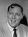
Kris Kristofferson
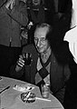
Bill Haley
William S. Burroughs

Tito Santana

Jack Morava (right)

Gloria Anzaldúa

.jpg)


.jpg)


Individual evidence
- ↑ a b c d e f g h i j k l m n Rio Grande Valley . David M. Vigness and Mark Odintz, Texas State Historical Association (TSHA), June 15, 2010; Upgrade: October 5th, 2015
- ↑ Elizabeth Cruce Alvarez, Robert Plocheck (eds.): Texas Almanac 2018/2019 , Texas State Historical Association (TSHA), Austin 2017, pp. 544-545 (Engl.)
- ↑ Alvarez, Plocheck: Texas Almanac 2018/2019 , page 77 (Engl.); Map Geologic Map of Texas , Texas Almanac, accessed January 11, 2019 (PDF; Engl.)
- ↑ Alvarez, Plocheck: Texas Almanac 2018/2019 , page 82 (Engl.); Map of Land Resource Areas , Texas Almanac, accessed January 11, 2019 (PDF; Engl.)
- ↑ See overview map on Hanna: Invest in the Rio Grande Valley . Mark Hanna, January 13, 2017 (Engl.)
- ^ Jeanette Erazo Heufelder: Welcome to Borderland. The US-Mexico border. Berenfeld Verlag, Berlin 2018, ISBN 978-3-946334-39-2 , maps pages 8–11.
- ↑ Alvarez, Plocheck: Texas Almanac 2018/2019 , page 92 (Engl.); Map Texas River Basins , Texas Almanac, accessed January 11, 2019 (PDF; Engl.)
- ↑ a b c See maps Cameron County , Hidalgo County , Starr County and Willacy County , Texas Almanac, each accessed on January 11, 2019 (PDF; Engl.)
- ↑ a b c d e f g h i j k l m n Cameron County . Alicia A. Garza and Christopher Long, Texas State Historical Association (TSHA), June 12, 2010; Upgrade: August 31, 2016 (Engl.)
- ↑ a b c d e f g h i j k l m n Hidalgo County . Alicia A. Garza, Texas State Historical Association (TSHA), June 15, 2010; Upgrade: February 5, 2016 (Engl.)
- ↑ a b Alvarez, Plocheck: Texas Almanac 2018/2019 , page 419 (Engl.)
- ↑ a b Alvarez, Plocheck: Texas Almanac 2018/2019 , pages 651, 654 and 660 (Engl.)
- ↑ Plant Guidance by Ecoregions , Texas Parks & Wildlife, accessed January 11, 2019 (Engl.)
- ↑ Preserving the Last Vestiges of Native Vegetation in the Greater McAllen-Edinburg Area: a Modest Proposal , J. Andrew McDonald, valleygreenspaces.com, October 2010 (Engl.)
- ↑ a b Lower Rio Grande Valley: Wildlife and Habitat , US Fish & Wildlife Service, June 11, 2012 (Engl.)
- ↑ a b See species listed by main group under Links on Species Lists , US Fish & Wildlife Service, July 9, 2012 (Engl.)
- ↑ Values of population figures for selected cities from statisticalatlas.com ; accessed on January 17, 2019 (Engl.).
- ↑ Interactive Map of Texas County Formation History , mapofus.org, accessed January 11, 2019.
- ↑ There Could Be Another High-Speed Rail Line In Texas: From Oklahoma To Rio Grande Valley . Stephanie Kuo, Kera News, August 12, 2016 (Engl.)
- ↑ Distance information is based on measurements of air line distances made in Google Earth
- ↑ Alvarez, Plocheck (ed.): Texas Almanac 2018/2019 , page 131 (Engl.)
- ↑ a b Alvarez, Plocheck (ed.): Texas Almanac 2018/2019 , page 130 (Engl.)
- ↑ Hurricane Alex begins dumping rain on south Texas , ap, nola.com, June 30, 2010 (Engl.)
- ↑ A Rich and Diverse Cultural History , The Valley Spotlight, accessed on January 11, 2019 (Engl.)
- ↑ Early Exploration of South Texas , The Valley Spotlight, accessed January 11, 2019.
- ↑ Spain Ignores Texas , The Valley Spotlight, access: January 11, 2019.
- ↑ a b Early Colonization of Spanish Texas , The Valley Spotlight, accessed on January 11, 2019.
- ↑ Heufelder: Welcome to Borderland , page 53 ff.
- ↑ Comanche Indians . Carol A. Lipscomb, Texas State Historical Association (TSHA), June 12, 2010; Upgrade: October 12, 2016 (Engl.)
- ↑ The Texas Apaches . R. Edward Moore, texasindians.com, access: January 11, 2019
- ↑ Transition From Spanish Texas to Mexican Texas , The Valley Spotlight, accessed January 11, 2019
- ↑ The Texas Revolution and The Mexican American War , The Valley Spotlight, access: January 11, 2019.
- ↑ Fort Brown . Elizabeth Pettit Davenport, Texas State Historical Association (TSHA), June 12, 2010; modified: March 4, 2011 (Engl.)
- ^ Cortina, Juan Nepomuceno . Jerry Thompson, Texas State Historical Association (TSHA), June 12, 2010; modified: March 28, 2016 (Engl.)
- ↑ The Civil War Era in the RGV , The Valley Spotlight, accessed on January 11, 2019 (Engl.)
- ↑ a b c d e Early Development of the RGV as an Agricultural Center , The Valley Spotlight, accessed on January 11, 2019 (Engl.)
- ↑ a b c d e Starr County . Alicia A. Garza, Texas State Historical Association (TSHA), June 15, 2010; Upgrade: May 1, 2017 (Engl.)
- ↑ a b Willacy County . Alicia A. Garza, Texas State Historical Association (TSHA), June 15, 2010; Upgrade: February 22, 2016 (Engl.)
- ↑ a b The Bandit War of 1915 , The Valley Spotlight, accessed on January 11, 2019 (Engl.)
- ↑ The Story of Rio Rico , The Valley Spotlight, access: January 11, 2019.
- ↑ Falcon Dam , Texas Archive of the Moving Image, accessed January 15, 2019.
- ↑ Vollrath Hopp: Water and Energy: Your Future Crises? , Springer Spectrum, Wiesbaden 2016, ISBN 978-3-662-48088-5 . P. 130 f. (partly online at Google Books )
- ↑ Mexico owes a lot of water to the USA and does not have enough itself , Andreas Knobloch, Tageswoche, September 12, 2014
- ↑ 1971: Police Riot and Protest Match in Pharr, TX . South Texas Rabble Rousers History Project, April 29, 2015
- ↑ Colonia . María-Cristina García, Texas State Historical Association (TSHA), June 12, 2010; Upgrade: July 28, 2015 (Engl.)
- ↑ Maquiladoras . Patricia A. Wilson, Texas State Historical Association (TSHA), June 15, 2010 (Engl.)
- ↑ Rio Grande Valley Tops List of "America's Poorest Cities" . Jason Cohen, Texas Monthly, Jan. 21, 2013
- ^ Fatal Journeys. Tracking Lives Lost during Migration . International Organization for Migration, 2014, page 56 (PDF; Engl.)
- ↑ a b One river, one country , The Economist, September 11, 1997 (Engl.)
- ↑ All Roads Lead From Roma , Kaye Northcott, Texas Monthly, April 1977 (Eng.)
- ↑ Heufelder, Welcome to Borderland, page 82 ff.
- ↑ a b c A Brief History of the Rio Grande Valley, Part I , Baltazar Acevedo y Arispe Jr., Rio Grande Guardian, July 20, 2014 (Engl.)
- ↑ a b c Backward decade data for the counties Cameron , Hidalgo , Starr and Willacy , population.us, accessed on January 16, 2019 (Engl.)
- ↑ Alvarez, Plocheck (ed.): Texas Almanac 2018/2019 , page 428 (Engl.)
- ↑ a b c Cameron County, Texas , Hidalgo County, Texas , Starr County, Texas, and Willacy Counties. ACS Demographic and Housing Estimates, 2017, American FactFinder, accessed January 16, 2019.
- Jump up ↑ Cameron County, Texas , Hidalgo County, Texas , Starr County, Texas , Willacy County , Texas, and United States . Brief overviews on the website of the United States Census Bureau, accessed on January 16, 2019 (Engl.)
- ↑ Hispanics give Democrats a boost in Texas (video). Tagesspiegel, November 5, 2018
- ↑ a b c 2016 Presidential General Election Results - Texas . Interactive map with results broken down by district 1789-2016 at eclection.org, accessed on January 16, 2019
- ↑ Alvarez, Plocheck (ed.): Texas Almanac 2018/2019 , page 562 (Engl.)
- ^ Cuellar, Gonzales, Vela Sworn Into 116th Congress Texas Congressmen Share Ambitions to Re-Open Government . Texas Border Business, Jan. 3, 2019
- ^ State House Districts. 86th Legislature 2019-2020 . Texas Legislative Council, accessed January 16, 2019 (PDF; ENgl.)
- ↑ House Members , Texas House of Representatives, accessed January 16, 2019 (Engl.)
- ↑ See Ryan Guillen , Oscar Longoria , Sergio Munoz Jr. , Armando Martinez , Terry Canales , Robert Guerra , Rene Oliveira and Eddie Lucio III in the politician database ballotpedia.org, accessed on January 16, 2019 (Engl.)
- ↑ Rio Grande Valley's historical heritage , The Valley Spotlight, accessed January 16, 2019.
- ↑ Alvarez, Plocheck (ed.): Texas Almanac 2018/2019 , page 271 (Engl.)
- ↑ Alvarez, Plocheck (ed.): Texas Almanac 2018/2019 , page 326 (Engl.)
- ↑ Alvarez, Plocheck (ed.): Texas Almanac 2018/2019 , page 398 (Engl.)
- ↑ Alvarez, Plocheck (ed.): Texas Almanac 2018/2019 , pages 651, 654 and 660 (Engl.)
- ↑ Positions oil and natural gas fields: see detailed view size on Texas General Land Office , mode "Geographic", The Texas General Land Office, accessed on January 16, 2019 (Engl.)
- ↑ Alvarez, Plocheck (ed.): Texas Almanac 2018/2019 , pages 271, 326, 398 and 419 (Engl.)
- ↑ See overviews for Counties Cameron , Hidalgo , Starr and Willacy , statisticalatlas.con, accessed January 17, 2019 (Engl.)
- ↑ Cameron County, TX and Hidalgo County , Education Sections, Data USA, accessed January 17, 2019.
- ↑ Heufelder, Welcome to Borderland, page 13 ff.
- ↑ a b The Music of the Rio Grande Valley , Nydia O, lavidavalle.com, October 26, 2012 (Engl.)
- ↑ Narco Corridos: The dark side of the Mexican music world , valleycentral.com, April 26, 2013 (Engl.)
- ↑ Freddy Fender , Garth Cartwright, The Guardian, October 16, 2006 (Engl.)
- ↑ Jeremy Halbreich targets Rio Grande Valley with latest newspaper venture , Cherry Hall, Dallas Morning News, July 28, 2012 (Engl.)
- ↑ The Go Guide , issuu.com and Sociallife (Homepage), accessed on January 17, 2019 (Engl.)
- ↑ About , lavidavalle.com, accessed January 17, 2019 (Engl.)
- ^ Doors officially open at Bert Ogden Arena in Edinburgh . ValleyCentral.com, August 28, 2018
- ↑ HEB Park , rgvfc.com., Accessed on January 17, 2019 (Engl.)
- ↑ TEXAS - Cameron County , TEXAS - Hidalgo County , TEXAS - Starr County and TEXAS - Willacy County , National Register of Historic Places, accessed January 17, 2019 (Engl.)
- ↑ Brownsville Museums , worldweb.com, accessed January 17, 2019 (Engl.)
- ↑ Welcome to the World Birding Center , worldbirdingcenter.com, accessed on January 17, 2019 (Engl.)
- ↑ Museum of South Texas History , mosthistory.com, accessed January 17, 2019.
- ↑ Laguna Atascosa National Wildlife Refuge , stateparks.com, accessed on January 17, 2019 (Engl.)
- ↑ Boca Chica Beach . US Fish & Wildlife Service, accessed January 17, 2019
- ^ Lower Rio Grande National Wildlife Refuge , William MacWhorter, Texas State Historical Association (TSHA), June 15, 2010 (Engl.)
- ↑ Rio Grande Valley People in Hollywood , cinesol.com, access: January 11, 2019.
- ↑ Bill Haley Dies, Classic Was "Rock Around Clock" . Martin Weil, Washington Post, February 10, 1981 (Engl.)
- ↑ The Lost Years of William S. Burroughs , realitystudio.org, August 2006 (Engl.)
Web links
- Rio Grande Valley in the Handbook of Texas Online (Engl.)
- Rio Grande Valley . Travel guide on Wikivoyage (Engl.)