
Roma (Texas)
| Roma | |||
|---|---|---|---|
.jpg) Historic building in the town center |
|||
| Location in Texas | |||
|
|||
| Basic data | |||
| Foundation : | 1936 | ||
| State : | United States | ||
| State : | Texas | ||
| County : | Starr County | ||
| Coordinates : | 26 ° 24 ′ N , 99 ° 0 ′ W | ||
| Time zone : | Central ( UTC − 6 / −5 ) | ||
| Residents : | 10.093 (as of 2016) | ||
| Population density : | 943.3 inhabitants per km 2 | ||
| Area : | 11.0 km 2 (approx. 4 mi 2 ) of which 10.7 km 2 (approx. 4 mi 2 ) are land |
||
| Height : | 65 m | ||
| Postal code : | 78584 | ||
| Area code : | +1 956 | ||
| FIPS : | 48-63020 | ||
| GNIS ID : | 1388200 | ||
| Website : | www.cityofroma.net | ||
| Mayor : | Roberto A. Salinas | ||

Roma (also known today as: Roma-Saenz ) is a city in Starr County in the US state of Texas . It is located in the southwestern part of the county on the Rio Grande , across from the Mexican settlement Ciudad Miguel Alemán in the state of Tamaulipas . Its roots go back to the end of the 18th century . The Roma – Ciudad Miguel Alemán International Bridge , built in 1928, is one of the most important border crossing stations in the lower Rio Grande Valley. The population of Roma in 2016 was 10,093.
geography
_(16656997452).jpg)
Geographically, Roma is part of a concentration of cities and towns of varying density that stretches along US Highway 83 on the north side of the Rio Grande and extends from Brownsville on the Gulf of Mexico to Falcon on the banks of the Falcon Reservoir . Neighboring towns on the American side are Fronton to the west and Escobares, Garceno and Loma Linda West in the east and northeast. Across the way, on the Mexican side of the river, is Ciudad Miguel Alemán. The two cities are connected by the Roma – Ciudad Miguel Alemán International Bridge . The urban area of Roma itself includes the - partly historical - town center, the two Colonias De la Cruz and Ala Blanca, the district of North Escobares and an area with the Roma High School located to the north.
The landscape of Roma lies in the southern Texas prairie region . The landscape is largely flat and characterized by grass , bushes and low wood growth. The ground height is around 65 meters above sea level. A spectacular vantage point is a sandstone rock hill that is located in the urban area on the banks of the Rio Grande and offers a panoramic view of the Mexican side of the river. In terms of regional breakdown, the city is part of the Rio Grande Valley - a region stretching north of the Rio Grande on the US side. The "Valley" is characterized by the industrial agriculture that emerged in the 20th century and the high Hispanic population and includes Starr County, the three counties to the east of Hidalgo , Cameron and Willacy .
The most important and only major connecting road is the US Highway 83, which leads from Brownsville along the Rio Grande to Laredo and from there branches off through the prairie states to North Dakota . The counterpart on the Mexican side is the Reynosa-Nuevo Laredo highway . The linear distance from Roma to the Mexican regional center Ciudad Mier is around 14 kilometers. It is 23 kilometers to Falcon at the southern end of the Falcon Reservoir, 80 kilometers to Reynosa , 135 kilometers to Laredo and 155 kilometers to Brownsville.
The climate in Roma is subtropical and subhumid with a continental character. The temperatures range from an average of 14 ° C in January up to 31 ° C in July. The average annual temperature is 23.5 ° C. The average rainfall is 5.2 centimeters per month. The heaviest month of rain is September; the month with the lowest monthly rainfall is March.
|
Average monthly temperatures and rainfall for Roma, Texas
Source: US climate data
|
|||||||||||||||||||||||||||||||||||||||||||||||||||||||||||||||||||||||||||
history

The foundation stone for the future town of Roma was laid by a Spanish mission that was built in 1751. In the 1760s, the ranchers Miguel, Gerónimo and Juan Ángel Saenz founded a hacienda , the area of which included both the area of today's Roma and that of Miguel Alemán on the other side of the Rio Grande. The settlement belonged to a catchment area of New Spanish villages, which lined up like a pearl necklace along the lower Rio Grande and which included Camargo, Reynosa, Refugio, Dolores, Mier, Revilla and Laredo. Due to the great distance to the central Mexican heartland, the residents oriented themselves to the north and northeast - towards San Antonio , from where a highway, the Camino Real de los Tejas , continued towards Louisiana .
About 15,000 Mexicans lived in the Rio Grande Valley around 1825. After the Mexican-American War in 1848, the settlement north of the Rio Grande was renamed Roma. The city prospered in the second half of the 19th century . The main reason for this was the fact that Roma was the westernmost river port for flat boats and steamers that sailed the lower Rio Grande. Due to its location, Roma benefited from cross-border smuggling early on . Before and during the civil war , tobacco and cotton were the main imports into Mexico. During the civil war, cross-border trade with Mexico played a major role in disrupting the Union 's maritime blockade .
The active role in cross-border trade protected the Mexican-American landowning elite in the city from being pushed aside by the class of Anglo-Saxon property speculators and land empresarios that was also forming in South Texas . Due to the expansion of new transport and traffic routes , which took little account of the place, the Roma were increasingly sidelined. In 1904 there were 521 residents in the city. A strong population growth began with the refugee movements as a result of the Mexican Revolution 1910-1917. In 1925 Roma got a rail link . With the Roma – Ciudad Miguel Alemán International Bridge , completed in 1927 , the town had a direct road connection to northern Mexico.

In 1931 the population had grown to 1,000. The number of shops and businesses was 30. In 1936 Roma received city rights as an Incorporated City . In the 1950s, a melon packaging plant and two cattle auction stalls were built. In 1951/52 the filming of the film Viva Zapata! by Elia Kazan held with Marlon Brando in the lead role. The completion of the Falcon Dam in 1953 ensured better protection against flooding . Further infrastructural measures were the construction of a new police building , a new community center as well as a stronger focus on the historical substance of the place, which was reflected in the foundation of the Roma Historical Museum in 1971 .


Unlike the long-established Mexican-Americans, the Hispanics newly arrived from Mexico found themselves more and more at the lower end of the social scale. The industrially operated form of truck-based agriculture with its production for commercial markets only slowly gained a foothold in the western, inland part of the Rio Grande Valley. The social gradient was expressed on the one hand in the emergence of so-called colonias - provisional settlements that were only poorly connected to the general communal networks. A second factor that favored the economic gap was the free trade zone south of the border with cheap labor - factories - the so-called maquiladoras , in the train of the North American Free Trade Agreement emerged (NAFTA) and to put the job offer in a simple, poorly paid manufacturing processes.
The Roma and the surrounding area increasingly developed into a cross-border arena in drug trafficking . This set in increasingly from the 1970s. As early as 1976, the South Texas Reporter, a weekly newspaper published in Roma, published the thesis that drug trafficking in the region is flourishing, among other things, because the population looks the other way, allows it and ultimately benefits economically from the illegal economy . The following year, Texas Monthly magazine characterized Roma as an important point on the transportation route for Mexican drug traffickers. In 2010, Roma were drawn into the drug war in northern Mexico in a fairly immediate way . In a massacre in the nearby town of Mier, in the course of which the Narco commandos involved carried out exemplary beheadings, members of the Gulf cartel also murdered Roma residents who were visiting relatives there. After the competing Zetas threatened retaliatory measures against the population living there, a general movement of refugees started from Mier, which also affected Roma in the foothills and significantly impaired the sense of security in the city.
The spectacular incidents in 2010 brought the border town temporary attention. The frequentation by the Mexican narco cartels continued in the following years. The population living there was skeptical or even negative about plans to expand the border fortifications along the Rio Grande. In addition to the fear that the wall targeted by Donald Trump would finally destroy traditional neighborly relations in the border region, there are ecological reservations: The construction of steel fences in the immediate vicinity of the river was stopped because the planned barrier would obstruct the flow of water from the Rio Grande Result of floods on the Mexican side and thus violates the border agreements between Mexico and the USA.
Demographics and Politics
| growth of population | |||
|---|---|---|---|
| Census | Residents | ± in% | |
| 1940 | 1414 | - | |
| 1950 | 1576 | 11.5% | |
| 1960 | 1496 | -5.1% | |
| 1970 | 2154 | 44% | |
| 1980 | 3384 | 57.1% | |
| 1990 | 8059 | 138.2% | |
| 2000 | 9617 | 19.3% | |
| 2010 | 9765 | 1.5% | |
The number of Roma residents grew steadily as early as the 19th century . However, the most significant increase has only occurred recently - in the decade between 1980 and 1990. While the population was 3,384 in 1980, ten years later it was already 8,059. In 2016, it was 10,093 people , according to data from the United States Census Bureau . 4,449 of these were male , 5,644 female , 7,067 residents were 18 years of age or older, 3,026 children or adolescents , 1,816 were older than 65 years. The median age was 36.8 years. 10,056 residents described themselves as Hispanic or Latino , 37 as white (0.4%). Afro-Americans , Asians and North American Indians were not represented with zero members, as were members of two or more ethnic groups. Compared to the county's demographics, the Hispanic population in Roma is even higher (almost 100 to 99.0%). The median age, on the other hand, deviates significantly from the district's values with a difference of around eight years (36.8 to 28.7).
According to Quickfacts info on census.gov , the median income per household was 19,842 US dollars (USD). The determined median value is well below that of the state of Texas (USD 54,700) and that of the USA as a whole (USD 55,300). Roma ranks at the bottom here; only the comparative values of a few other places in the Rio Grande Valley bring even lower values. The census showed 50.7% of people living in poverty and 34.5% of people without health insurance.

The political preferences of the Roma voters correspond to the particularities that apply to the entire region of South Texas, especially the counties along the Rio Grande. In the 2016 presidential election , Hillary Clinton received around 79% in Starr County, while Donald Trump only received 19% (comparative values for all of Texas: 43% and 52%). The Democrats also achieved results well above the national average in the 2012 , 2008 , 2004 and 2000 presidential elections . With well over 70 to sometimes well over 80%, the votes for the Democrats in Starr County were even higher than in the other traditionally democratic counties north of the Rio Grande. The dominance of the Democratic Party in this region over the leading Republicans in all of Texas is historical. It goes back well into the 19th century and is in large part due to the fact that the Democrats are seen as the traditional political interest group, especially among the Hispanic population. The trend described is also reflected in the MPs for the US House of Representatives . For the 28th congressional district of Texas this office has held since 2004 - as a pronounced conservative Democrat - politician Henry Cuellar .
Economy, education and culture
.jpg)
Agriculture is still a not insignificant factor in the area around the city. In 19900 100,000 hectares of irrigated river bed were designated for dry farming north of the city. The statisticalatlas.com website shows the health care (22.2%), education (21.8%), building and construction (13.7%) and trade and sales (10.2%) sectors as the most important economic sectors . 54.5% of employees work in the private sector, 19.7% in the state and 15% self-employed. The specified occupational fields - with the most frequently mentioned health care, education and construction / construction - correspond roughly to those of the corresponding industries.
The responsible school district is the Roma Independent School District. The Middle School offer is split into the districts of Roma Middle School in the western part and Barrera Middle School in the eastern part. The Roma High School, founded in 1990 and located in the north of the city, offers higher school-leaving qualifications.
Due to the almost homogeneous Hispanic population, Spanish is the main language. The Roma National Historic Landmark District includes over 30 buildings that were constructed before 1900. Historical buildings include: the old customs office (Casa de Aduanas), the Nuestra Señora del Refugio de los Pecadores church and the Leocadia Garcia House, Ramirez Hall, Manuel Guerra House, the Nestor Saenz Store and the Edward Hord Office buildings. The historical sights are complemented by the Roma Historical Museum , built in 1973 .
A scenic highlight is a hill in the city center, which provides an overview of the Mexican side of the Rio Grande. In addition, Roma is a popular bird watching spot in the Rio Grande Valley. Part of the World Birding Center is on Portsheller Street across from City Hall. Well-known artists with a local background are the Roma-based Norteño band Duelo and the author Jovita González. The mariachi group Mariachi Nuevo Santander, which formed at Roma High School, has appeared on several television shows. The city is also set in Larry McMurtry's 1972 novella All My Friends Are Going to Be Strangers .
- Historic Landmarks in Roma

Historic town center

Church 1

Church 2
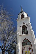
Church 3
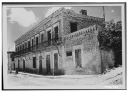
Manuel Guerra Residence and Store

Leocadia Leandro Garcia House
.jpg)
Individual evidence
- ↑ See map Starr County , Texas Almanac, accessed November 10, 2018 (PDF)
- ^ Overview of Roma, Texas . Map on statisticalatlas.com, accessed November 10, 2018
- ↑ Land Resource Areas . Map with landscape structure on texaxalmanach.com, accessed on November 10, 2018 (English; PDF)
- ↑ Rio Grande Valley . David M. Vigness / Mark Odintz, Texas State Historical Association (TSHA), June 15, 2010 (Engl.)
- ↑ Climate Roma - Texas , usclimatedata.com, accessed November 10, 2018 (Engl.)
- ^ A b Jeanette Erazo Heufelder : Welcome to Borderland. The US border. Berenberg Verlag, Berlin 2018, ISBN 978-3-946334-39-2 , p. 14 ff.
- ↑ a b c d e f Roma-Los Saenz, TX . Dirk D. Heller, Jr., Texas State Historical Association (TSHA), June 15, 2010 (Engl.)
- ↑ Heufelder, Welcome to Borderland, pp. 19 ff.
- ↑ a b c Heufelder, Welcome to Borderland, pp. 73 ff.
- ^ All Roads Lead From Roma , Kaye Northcott, Texas Monthly, April 1977 (Engl.)
- ^ Population of Roma, TX . Overview graphic on population.us, accessed on November 10, 2018 (Engl.)
- ^ Roma city, Texas . ACS Demographic and Housing Estimates, 2016, American FactFinder, accessed November 10, 2018.
- ↑ Starr County, Texas . ACS Demographic and Housing Estimates, 2016, American FactFinder, accessed November 10, 2018.
- ↑ a b Roma city, Texas , brief overview on the website of the United States Census Bureau, accessed November 10, 2018 (Engl.)
- ^ Household Income in Roma, Texas . Household income overview on statisticalatlas.com, accessed November 10, 2018
- ↑ 2016 Presidential General Election Results - Texas . Interactive map with district-broken down results 1789-2016 at eclection.org, accessed on November 10, 2018 (Engl.)
- ↑ Hispanics give Democrats a boost in Texas (video). Tagesspiegel, November 5, 2018
- ↑ See Industries in Roma, Texas , Sectors in Roma, Texas, and Occupations in Roma, Texas , statisticalatlas.com, accessed November 10, 2018.
- ↑ Roma ISD Middle School Boundaries , Roma Independent School District, accessed November 10, 2018 (PDF; Engl.)
- ↑ Roma Historic District , National Park Service / South and West Texas, accessed November 10, 2018.
Web links
- Official homepage of Roma (Engl.)
- Roma-Los Saenz in the Texas Handbook (Engl.)