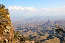
Chihuahua desert
The Chihuahua Desert is located on the border between the United States and Mexico . With an area of approx. 518,000 km² it is the largest of all North American deserts and is mainly in the area of the Mexican states Chihuahua and Coahuila . However, its foothills extend as far as some US states: It occupies southeastern parts of Arizona , southern New Mexico and western Texas . In a southerly direction it extends to the Mexican states of Zacatecas and San Luis Potosí .
The Chihuahua Desert can be categorized as a rain shadow desert . This is the case because it is shielded by the Sierra Madre to the west and east. These two mountain ranges keep much of the moisture that comes from the Gulf of Mexico away from the desert area. This is also the main reason for the formation of the desert.
The desert is a desert basin, which is interrupted by several smaller mountain ranges such as the Sacramento Mountains , Guadalupe Mountains and the Davis Mountains . These mountain areas are much cooler and more humid than the desert and are overgrown by coniferous forests.

Compared to the Sonoran Desert bordering to the west , the differences in altitude in the Chihuahua are significantly greater; they vary between 600 and 1675 meters. As a result, the summer is usually a little milder than in Sonora. The average temperatures in June are between 35 and 40 ° C, in winter it can even get very cold at higher altitudes. The amount of precipitation in the Chihuahua is also slightly higher than in the other deserts of the region (in addition to the Sonora also the Mojave Desert and the Great Basin ), but it is also well below 250 millimeters here. Most of the precipitation is concentrated in a short " monsoon " phase in late summer. Snow only falls at high altitudes.
The Chihuahua Desert is characterized by typical desert vegetation, consisting of agave lechuguilla , mesquites , yuccas , Dasylirion wheeleri and various grasses . Big Bend National Park and the Prehistoric Trackways National Monument are located in the Chihuahua Desert .
White Sands

White Sands ("white sand") is the name of a gypsum desert in the Tularosa Basin in the south of the US state New Mexico. It's the most unusual part of the Chihuahua Desert. The area was declared a White Sands National Monument in 1933 . The “white sand” is plaster of paris . This gypsum comes from the surrounding mountains through precipitation into Lake Lucero , which is located in the southwestern corner of White Sands and has no drain. In the summer months with sometimes extreme heat, this lake dries up and only the gypsum crystals remain , which are thrown into dunes by the southwest winds and form the largest gypsum desert in the world with approx. 700 km².
In the area of the White Sands is the White Sands Missile Range , a missile test site of the US Army , where the first atomic bomb explosion ( Trinity test ) took place in 1945 . In addition, the base was once an alternate landing site for the space shuttle , as happened in 1982 during the Columbia STS-3 mission . NASA therefore also calls the alternative landing site White Sands Space Harbor .
See also
Individual evidence
- ↑ https://www.desertusa.com/chihuahuan-desert.html
- ↑ a b New Mexico State University: The Chihuahuan Desert ( Memento of the original from December 27, 2012 in the Internet Archive ) Info: The archive link was inserted automatically and has not yet been checked. Please check the original and archive link according to the instructions and then remove this notice. , last accessed on November 23, 2013.
