
San Luis Potosí (State)
| San Luis Potosí | ||
|---|---|---|
|
 .svg) |
|
| Capital | San Luis Potosí | |
| surface | 60,983 km² (rank 15 ) | |
| population | 2,785,718 (ranked 16 ) | |
| Population density | 42.6 inhabitants per km² (2010 census) |
|
| governor |
Juan Manuel Carreras ( PRI ) (2015-2021) |
|
| Federal MPs |
PRI = 2 PRD = 2 PVEM = 1 PAN = 1 PT = 1 (7 federal constituencies) |
|
| Senators |
PRD = 1 PAN = 2 Morena = 1 |
|
| ISO 3166-2 | MX-SLP | |
| Postal abbreviation | SLP | |
| Website | www.sanluispotosi.gob.mx | |

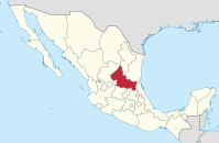
The state of San Luis Potosí [ san ˈlwis potoˈsi ], officially Free and Sovereign State of San Luis Potosí ( Spanish Estado Libre y Soberano de San Luis Potosí ), is located in the north-central part of Mexico . It borders Zacatecas and Nuevo León in the north, Tamaulipas in the northeast, Veracruz in the southeast, Hidalgo , Querétaro and Guanajuato in the south, Jalisco in the southwest and Zacatecas in the west. With an area of almost 61,000 km², the state has a population of around 2.8 million (2010).
The majority of the area is taken up by a high plateau with a dry climate. Typical representatives of the vegetation are yucca , agaves , cactus plants (including nopal prickly pear cacti , organ cacti, peyote ) and mesquites , in the temperate zones also oaks and pines . The highest elevation reaches 3180 m. To the east, the state's landscape slopes down to the coast and forms part of the humid tropical Huasteca region . The lowest point is 100 m above sea level.
In addition to the capital San Luis Potosí , Soledad de Graciano Sánchez , Ciudad Valles , Matehuala and Rioverde are important. The mining town of Real de Catorce , located in a valley, is of tourist interest .
The state of San Luis Potosí is divided into 58 municipalities .
Population development
| year | population |
|---|---|
| 1950 | 856.066 |
| 1960 | 1,048,297 |
| 1970 | 1,281,996 |
| 1980 | 1,673,893 |
| 1990 | 2,003,187 |
| 1995 | 2,200,763 |
| 2000 | 2,299,360 |
| 2005 | 2,410,414 |
| 2010 | 2,585,518 |
| 2015 | 2,717,820 |
Web links
Aguascalientes | Baja California | Baja California Sur | Campeche | Chiapas | Chihuahua | Coahuila | Colima | Durango | Guanajuato | Guerrero | Hidalgo | Jalisco | México | Mexico City | Michoacan | Morelos | Nayarit | Nuevo León | Oaxaca | Puebla | Querétaro | Quintana Roo | San Luis Potosí | Sinaloa | Sonora | Tabasco | Tamaulipas | Tlaxcala | Veracruz | Yucatán | Zacatecas
Coordinates: 22 ° 36 ′ N , 100 ° 26 ′ W