
San Luis Potosí (city)
| San Luis Potosí | ||
|---|---|---|
|
Coordinates: 22 ° 9 ′ N , 100 ° 59 ′ W San Luis Potosí on the map of San Luis Potosí
|
||
| Basic data | ||
| Country | Mexico | |
| State | San Luis Potosí | |
| Municipio | San Luis Potosí | |
| City foundation | November 4, 1592 | |
| Residents | 722,772 (2010) | |
| City insignia | ||
 |
 |
|
| Detailed data | ||
| surface | 151 km 2 | |
| Population density | 4,787 inhabitants / km 2 | |
| height | 1850 m | |
| Website | ||
 |
||
 |
||

San Luis Potosí is a city with approx. 750,000 inhabitants in north-central Mexico and the capital of the state of the same name . It was founded on November 4, 1592. The historic center of the city was in 2010 as part of the Camino Real de Tierra Adentro by the UNESCO as a world heritage site classified.
San Luis Potosí forms the core of the Zona Metropolitana de San Luis Potosí with over one million inhabitants. In addition, San Luis Potosí is the administrative seat of the Municipio San Luis Potosí and the seat of the Archdiocese of San Luis Potosí .
Location and climate
The city, located approx. 440 km northwest of Mexico City and approx. 1850 m high, is bordered to the east by the Sierra de Álvarez and to the west by the Sierra San Miguelito . The highest elevation and at the same time the local mountain of San Luis Potosí is Cerro el Potosí ( 2670 m ) in the southwest . The climate is dry and warm; Rain (approx. 340 mm / year) falls mainly in the summer half-year.
Population development
| year | 2000 | 2005 | 2010 |
| Residents | 629.208 | 685.934 | 722.772 |
The significant increase in population is mainly due to the ongoing immigration of individuals and families from the surrounding villages.
economy
The importance of the city as a "silver city" has decreased in the course of history and is now zero. Several international companies have set up shop in the Zona Industrial of San Luis Potosí, especially those from the steel and automotive industries , e.g. B. Thyssenkrupp , Daimler , Continental , EJOT-ATF Fasteners de Mexico ( EJOT ), Dräxlmaier Group and Bizerba . The BMW AG since 2016 building a plant that since the 2019 BMW 3 Series produced.
The private university Instituto Tecnológico y de Estudios Superiores de Monterrey (ITESM) has a campus in San Luis .
history
San Luis Potosí is one of the "silver cities" of Mexico, but has always been economically important as the center of a cattle breeding area. It was named after the French King Louis IX. , called "Louis the Holy" (hence San Luis ) and the silver city of Potosí in today's Bolivia , as one expected just as much wealth as from the local mines . During the French intervention in Mexico (1861-1867), San Luis Potosí was the seat of the republican government under Benito Juárez .
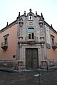
Attractions
The historic city center has many colonial buildings - especially the facades of the three-aisled cathedral and that of the Santuario de Nuestra Señora de Guadalupe with their protruding central parts are very worth seeing. In 2001 the city center was put on Mexico's tentative list for UNESCO World Heritage . In 2010 it was added to the World Heritage List as part of the Camino Real de Tierra Adentro .

Santuario de Nuestra Señora de Guadalupe

central place

Templo de San Miguel

Casa de la Accion Catolica
Caja Real (18th century)

Glass palace (19th century)
.jpg)

.jpg)


Personalities
- Anastasio Bustamante (1780-1853), three-time President of Mexico; after studying medicine as director of the hospital in San Luis Potosí
- Lupe Vélez (real. María Guadalupe Vélez de Villalobos ; 1908–1944), actress
- José Saber Marroquín (1909–1995), composer and conductor
- Ezequiel Perea Sánchez (1911–1986), Bishop of San Luis Potosí
- Francisco Eppens Helguera (1913–1990), artist and painter of the current national coat of arms
- Manuel Saber Marroquín (1914–1990), pianist and composer
- José Maclovio Vásquez Silos (1918–1990), Bishop of Autlán
- Mil Máscaras (aka Aaron Rodriguez; * 1942), wrestling legend and actor
- Patria Jiménez (* 1957), politician
- Alberto Del Rio (aka Alberto Rodriguez; * 1977), wrestler
- Nery Castillo (* 1984), football player
- Manuel Sánchez (tennis player) (born 1991), tennis player
- Omar Govea (* 1996), football player
Web links
- Sa Luis Potosí - Sightseeing (Spanish)