Large pool


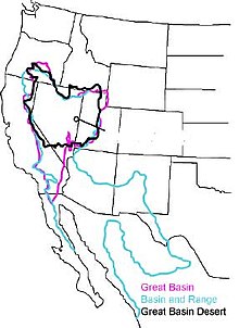
The Great Basin ( English Great Basin ) is a dry bulk landscape that stretches to the west of the United States between the Wasatch Range to the east and the Sierra Nevada and Cascade Range to the west across several US states , but mostly in Nevada , covers. Oregon , Idaho , Utah , Arizona and California also have smaller shares . The boundaries of the Great Basin are defined differently: The Great Basin is generally understood to mean the areas that form a drainage-free catchment area . The Great Basin Desert is understood to mean the areas in which the characteristic vegetation of the Great Basin predominates. Basin and Range is a geological region that is much larger than the actual basin and also includes the Mojave and Sonoran Deserts in Mexico .
Also one of the North American cultural complexes of the indigenous population is Great Basin ( Great Basin called).
Classification
The large basin consists of around 100 partial basins or valleys in which there are numerous “mountain islands”. It is of steppe-like areas, stone and sand desert thunderstorm lying Bach - and rivers , canyons , salt lakes and pans and some small and large lakes (eg Great Salt Lake , Utah Lake and Pyramid Lake ) coined. In the north of the Great Basin runs the Humboldt River , which ends in the west under the flank of the Sierra Nevada in small lakes with no drainage, in which the water evaporates in the desert air.
The valleys or sub-basins that form their own drainage-free catchment areas are:
(If an area is located in more than one state, the first indicated after the dash is the one in which the largest part of the area is located.)
- Nevada:
- Winnemucca Lake - Nevada
- Granite Springs Valley - Nevada
- Dixie Valley - Nevada
- Gabbs Valley - Nevada
- Big Smoky Valley - Nevada
- Diamond Valley - Nevada
- Monitor Valley - Nevada
- Litte Smoky Valley - Nevada
- Ruby Valley - Nevada
- Spring Valley - Nevada
- Steptoe Valley - Nevada
- Dry Lake Valley - Nevada
- Soda Spring Valley - Nevada
- Ralston Valley - Nevada
- Stone Cabin Valley - Nevada
- Hot Creek Valley - Nevada
- Railroad Valley - Nevada
- Cactus Flat - Nevada
- Sarcobatus Flat - Nevada
- Sand Spring Valley - Nevada
- Tikaboo Valley - Nevada
- Humboldt Sink - Nevada (drains the Humboldt River , the longest river in the Great Basin)
- Nevada and California:
- Smoke Creek Desert - Nevada , California
- Massacre Lake - Nevada, California
- Lake Tahoe with the Truckee River draining into Pyramid Lake
- Carson Sink - Nevada, California
- Walter Lake - Nevada, California
- Fish Lake Valley - Nevada, California
- Ivanpah Valley - Nevada, California
- Pahrump Valley - Nevada, California
- Surprise Valley - California , Nevada
- Madeline Plains - California, Nevada
- Honey Lake - California, Nevada
- Mono Lake - California, Nevada
- Crowley Lake - California, Nevada
- Eureka Valley - California, Nevada
- Death Valley - California, Nevada (lowest point in the US)
- California:
- Buena Vista Lake - California
- Lake Elsinore - California
- Eagle Lake - California
- Owens Lake - California
- Saline Valley - California
- Panamint Valley - California
- Indian Wells Valley - California
- Searles Valley - California
- Antelope Valley - California
- Fremont Valley - California
- Coyote Lake - California
- Cuddeback Lake - California
- Mojave River - California
- Mojave Desert (Mojave Desert) - California
- Salton (Salton Sea) - California
- Nevada and Utah:
- Hamlin Valley - Nevada , Utah
- Pilot Creek - Nevada, Utah
- Thousand Springs Creek - Nevada, Utah
- Great Salt Lake Desert (Great Salt Lake Desert) - Utah , Nevada
- Snake Valley - Utah, Nevada
- Escalante Desert - Utah, Nevada
- Utah:
- Pine Valley - Utah
- Tule Valley - Utah
- Rush Valley - Utah
- Tooele Valley - Utah
- Skull Valley - Utah
- Sevier Lake - Utah
- Beaver River - Utah
- Nevada and Oregon:
- Black Rock Desert - Nevada , Oregon
- Continental Lake - Nevada, Oregon
- Alvord Lake - Oregon , Nevada
- Oregon:
- Harney Basin - Oregon
- Summer Lake - Oregon
- Silver Lake - Oregon
- Lake Abert - Oregon
- Guano Lake - Oregon
- Oregon and California:
- Lost River - California, Oregon
- Butte Creek - California, Oregon
- Goose Lake - California, Oregon
- Oregon and California and Nevada:
- Warner Lakes - Oregon, California, Nevada
- Utah and Idaho:
- Curlew Valley - Utah, Idaho
- Utah and Idaho and Wyoming:
- Great Salt Lake (Great Salt Lake) - Utah, Idaho, Wyoming ( Bear River , Jordan River and Weber River )
history
While the lower rock layers come from the Archean , the surface shape of the Great Basin is only about 17 million years old.
Due to a surveying error in the Great Basin region, it was believed until the 1840s that a river called the Buenaventura River connected the Great Salt Lake with the Pacific.
mountains
- Boundary Peak ( 4007 m ) - on the eastern slope of the Sierra Nevada
- Wheeler Peak ( 3982 m ) - in the 312 km² Great Basin National Park
Cities
literature
- Donald K. Grayson: The Great Basin. A Natural Prehistory . University of California Press, Berkeley 2011, ISBN 978-0-520-94871-6 .


