Winnemucca Lake

The Winnemucca Lake is a dried out lake today in the State of Nevada on the border between Washoe County and Pershing County . It was a remnant of prehistoric Lake Lahontan and lost its inflow at the beginning of the 20th century due to hydraulic engineering work on the Truckee River . Since the 1930s it has only collected water intermittently after rainfall.
The lake basin is around 45 km long and around 7 km wide at its widest point. Nevada State Route 447 , which connects Fernley with Gerlach , runs on the western edge of the lake .
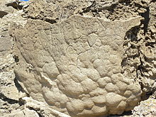
The lake is named after the Paiute chief Old Winnemucca (* approx. 1820, † 1882). The oldest known petroglyphs on the American continent were found at the lake . They are dated between 11,300 and 10,500 cal. Before Present .
Hydrology
Winnemucca Lake is 1150 m above sea level in an outflow-free depression that belongs to the Basin and Range Province . At the end of the last ice age, Lake Lahontan was formed on the east side of the Sierra Nevada , which was divided into several smaller end lakes in the individual basins due to further climatic changes and falling water levels . One such end lake is today's Pyramid Lake , which then covered a much larger area. It consisted of two V-shaped connected basins, between which the Lake Range protruded from the north as a peninsula. As the water level continued to fall, the two basins split into two lakes, Pyramid Lake to the east and Winnemucca Lake to the west. Both were fed from the Truckee River.
In 1905 the Derby Dam on the Truckee River was completed as the first project of the Bureau of Reclamation , founded in 1902 . As a result, water from the river was diverted to irrigate agricultural areas, the inflow to Pyramid Lake no longer reached the necessary height to overflow over a threshold into Winnemucca Lake, so that only Pyramid Lake has an inflow. Winnemucca Lake dried up completely until the 1930s and now only carries a small amount of water shortly after it rains. During the expansion of Nevada State Route 447, a dam was raised, which further limits the inflow.
history
The region around Winnemucca Lake was originally inhabited by a band of the Paiute . They used the pond rushes that occur in large numbers at the lake , which they called tule , for all kinds of wattle. They used it to make baskets, mats and clothing.
In 1865 a battle took place as part of the Snake War at Winnemucca Lake, which the whites then called Mud Lake . After all regular army units by setting just ended Civil War were tied in the eastern United States, had in western militias formed that were poorly trained in general and not very disciplined. On March 14, 1865, 29 volunteers from the 1st Battalion Nevada Volunteer Cavalry pursued a group of Paiute Indians accused of stealing cattle. They reached the group in the immediate vicinity of the lake and a battle ensued in which about 30 Indians were killed and, according to contemporary reports, only one escaped. It is unclear whether the Indians were mostly young warriors or whether a wandering tribal group with old people, women and children were killed. The number of women fluctuates between 2 and 18 depending on the information. Among the victims was a son of chief Winnemucca and brother of Indian rights activist Sarah Winnemucca .
Petroglyphs
At the end of the last Ice Age, the water level of Lake Lahontan fluctuated considerably over a long period of time. Climate change and the subsequent glacier melt in the Sierra Nevada were responsible. The area of Winnemucca Lake was already settled at that time, the residents left large stone carvings known as petroglyphs.
Due to the strongly fluctuating climate, tufa fell out in times of drought . Some petroglyphs were scratched in a dry phase just above the water level. When the water level rises, the water covered them again and in the next dry phase a layer of tuff was deposited on the scratches. These can be dated and the age of the petroglyphs can be determined through the sequence of scratches under datable tuff layers.
The values of 11,300 to 10,500 cal. Years Before Present lie in the transition between the Paleo-Indian and the early Archaic period and are the oldest known petroglyphs in America.
Web links
Winnemucca Lake in the Geographic Names Information System of the United States Geological Survey
Individual evidence
- ^ Pyramid Lake Paiute Tribe: Winnemucca Dry Bed - Visitor Information ( Memento of May 8, 2014 in the Internet Archive ). October 27, 2008
- ^ Winnemucca Lake in the Geographic Names Information System of the United States Geological Survey
- ^ National Park Service: Derby Diversion Dam
- ^ Water Education Foundation: Remnants of the Past: Management Challenges of Terminal Lakes . In: Western Water , January / February 2005
- ^ LV Benson, EM Hattori, et al .: Dating North America's oldest petroglyphs, Winnemucca Lake subbasin, Nevada . In: Journal of Archaeological Science , Volume 40 (2013) pages 4466-4476, doi: 10.1016 / j.jas.2013.06.022
Coordinates: 40 ° 7 ′ 18.7 ″ N , 119 ° 20 ′ 22.6 ″ W.

