Truckee River
| Truckee River | ||
|
Overview map |
||
| Data | ||
| location | California / Nevada , United States | |
| River system | Truckee River | |
| source | On Lake Tahoe in the Sierra Nevada Mountains, 39 ° 10 ′ 3 ″ N , 120 ° 8 ′ 36 ″ W |
|
| muzzle | In Pyramid Lake , Nevada coordinates: 39 ° 51 ′ 17 " N , 119 ° 26 ′ 17" W 39 ° 51 ′ 17 " N , 119 ° 26 ′ 17" W |
|
| Mouth height |
1155 m
|
|
| length | 225 km | |
|
Truckee River east of Truckee, California in winter |
||
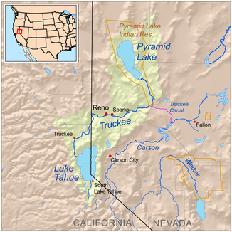
The Truckee River [ trʌkiː ˈɹɪvɚ ] is a 225 km long river located in the westernmost part of the Great Basin in northern California and Nevada . It drains part of the high Sierra Nevada . The relatively water-rich river has its source south of Lake Tahoes and empties into the outflow-free Pyramid Lake . The river's water is clear at the headwaters, but becomes muddy as soon as it passes Reno .
Run
The river rises as the Upper Truckee River in the mountains south of Lake Tahoe on the border of the two US states of California and Nevada, into which it flows at its southern end. It leaves the lake in the northwest at Tahoe City and follows a northwest direction to Truckee , before turning sharply east and flowing into Nevada. It passes Reno and Sparks and the north end of the Carson Range . In Fernley , its direction changes north and it flows along the eastern edge of the Pah Rah Range before flowing into Pyramid Lake in Washoe County at its southern end.
Significance for the settlement of the west
In the wake of the California gold rush , several variants of the California Trail settler route ran partly along the river and up into the Sierra Nevada. The Beckwourth Trail , which branched off to the northwest from the river in what is now Reno, Nevada, and the route over Donner Pass , on which Interstate Highway I-80 still runs, were significant .
Web links
- Reno Gazette-Journal Special Report on the Truckee River (English)
- Truckee River Watershed Council (English)
- Tahoe Institute for Natural Science (English)

