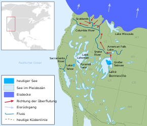
Lake Lahontan
Lake Lahontan is the name of an endorheic lake during the Ice Age . Most of it was located in what is now the US states of Nevada , California and Oregon in the so-called Great Basin .
At the time of its greatest expansion around 12,700 years ago, the lake covered a large part of the northwest of today's Nevada with an area of around 22,015 km² and covered the Black Rock Desert . Its deepest point, about 275 meters, was where Pyramid Lake is still today . During this time it was probably the largest lake in North America.
The lake dried up around 9,000 years ago. Today a reservoir is named after him, the Lahontan Reservoir .
Web links
Commons : Lake Lahontan - Collection of Images, Videos, and Audio Files
- The Lake Lahontan Expedition , rangerovers.net
- Lahontan State Recreation Area , Nevada State Parks
Individual evidence
- ^ Donald K. Grayson: The Desert's Past - A Natural Prehistory of the Great Basin. Smithsonian Institution Press, Washington 1993, ISBN 1-56098-222-5 .
