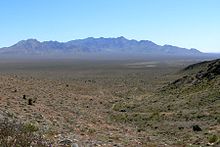
Basin and Range Province
The Basin and Range Province is a very spacious geological province that encompasses large parts of the southwestern United States and northwestern Mexico . The determining geomorphological element are the Basin and Ranges (basins and ridges), which represent a topography of parallel clumps and ditches .
expansion

The province extends from the Colorado Plateau westward to the Sierra Nevada and encloses northeast Baja California to the south . On the US side, it extends over parts of the states of Arizona , Idaho , California , New Mexico , Oregon , Texas , Utah and practically all of Nevada (only a small part of northern Elko County drains to the Snake River ). On the Mexican side, the states of Baja California , Chihuahua and Sonora also have typical basin and range topography.
The longitudinal extension amounts to a total of 3000 kilometers, the southernmost point of the province is immediately north of Mexico City , Oaxaca itself may have been affected. The maximum latitude reaches 1000 kilometers, which, however, is reduced to only 350 kilometers at the latitude of Las Vegas .
The Sierra Madre Occidental divides the Basin and Range Province into two halves on the Mexican side.
As large landscapes, the arid Great Basin , the Chihuahua Desert and the Sonoran Desert largely belong to the Basin and Range Province.
Geological evolution
The nest and trench topography of the Basin and Range Province results from crustal expansion . The Laramian orogeny , which created the Rocky Mountains , was initiated when the Farallon Plate plunged under the North American Plate from the west, generating pressure in a west-east direction. It ended around 35 million years ago when the Farallon Plate was completely subducted except for small fragments in the subduction zone on the west coast of North America. When the lateral pressure on the North American plate was eliminated, the previously compressed rocks were stretched. Parallel ridges were excavated on north-south trending faults, and at the same time rift zones sank in the same faults. In this way, the alternating pattern of straight ridges (ranges) and basins (basins) was created.
As early as 35 million years BP ( Upper Eocene , Priabonian ), the first flat-lying faults began with the stretching process of the tectonically thickened crust and metamorphic core complexes (bulges of the metamorphic lower crust) formed. However, the actual crustal expansion did not begin until around 16 million years BP ( Miocene , Langhium ), the direction of expansion was east-northeast. From the Upper Miocene ( Tortonian ) eight million years ago BP, a second phase in the expansion process took place with a clockwise change of direction to east-southeast, and the tectonic style also changed. Steep faults dominated the previous structures, and the current eyrie and trench structure emerged.
The fact is that the crust has expanded up to 100 percent in its original width dimension and is now one of the thinnest areas of crust in the world below the Basin and Range Province.

Natural resources
Almost all of the copper and much of the United States' gold , silver and barite production come from the Basin and Range Province . Some oil is even produced in Nevada .
See also
Footnotes
- ^ Robert B. Smith, Lee J. Siegel: Windows into the Earth . Oxford University Press, 2000, ISBN 0-19-510596-6 , p. 102 f.
- ^ Geologic Provinces of the United States: Basin and Range Province. United States Geological Survey ( Memento of the original from January 25, 2009 in the Internet Archive ) Info: The archive link was inserted automatically and has not yet been checked. Please check the original and archive link according to the instructions and then remove this notice.
Web links
swell
- John McPhee: Basin and Range. Noonday Press, 1990, ISBN 0-374-51690-1 .
- Steven M. Stanley: Earth System History. WH Freeman and Company, 1999, ISBN 0-7167-2882-6 , pp. 537, 540-543, 545.
- W. Scott Baldridge: Geology of the American Southwest: A Journey Through Two Billion Years of Plate Tectonic History. Cambridge University Press, 2004, ISBN 0-521-01666-5 ( Google Books )
- Charles C. Plummer, David McGeary, Diane H. Carlson: Physical Geology. 8th edition, McGraw-Hill, Boston 1999, ISBN 0-697-37404-1 , pp. 321, 513, 514.


