Weber River
| Weber River | ||
| Data | ||
| location | Utah , United States | |
| River system | Weber River | |
| source | in the Uinta Mountains 40 ° 42 ′ 56 " N , 110 ° 53 ′ 58" W |
|
| Source height | 3055 m | |
| muzzle | in the Great Salt Lake Coordinates: 41 ° 9 ′ 25 ″ N , 112 ° 11 ′ 50 ″ W 41 ° 9 ′ 25 ″ N , 112 ° 11 ′ 50 ″ W |
|
| Mouth height | 1281 m | |
| Height difference | 1774 m | |
| Bottom slope | 8.8 ‰ | |
| length | 201 km | |
| Catchment area | 6413 km² | |
| Left tributaries | Beaver Creek , Silver Creek , East Canyon Creek | |
| Right tributaries | Echo Creek , Lost Creek , Ogden River | |
| Reservoirs flowed through | Rockport Lake , Echo Reservoir | |
| Medium-sized cities | Ogden | |
| Small towns | Oakley , Coalville , Henefer , Morgan , Riverdale | |
|
in Weber Canyon |
||
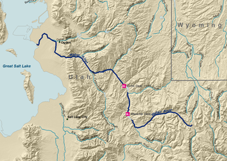
The Weber River ( ˈwiːbər ) is an approximately 200 km long river in northern Utah in the United States . It begins in the northwest of the Uinta Mountains and flows into the Great Salt Lake . The Weber River was named after the German-American trapper John Henry Weber .
course
The Weber River rises in the northwest of the Uinta Mountains at the foot of the peaks of Bald Mountain , Notch Mountain and Mount Watson . It passes the town of Oakley and flows through the Rockport Lake reservoir . Then it turns north and takes two important tributaries, the Silver Creek and at Coalville the Chalk Creek . Below the Echo Reservoir , the river flows past Henefer , turns further west, and then passes Morgan , where it receives East Canyon Creek . It emerges from the Wasatch Mountains at Uintah after flowing through the Weber Canyon and turns again to the north, where it takes up the Ogden River west of Ogden . From then on, the river meanders through mostly flat land and flows into the Great Salt Lake in silt plains, discharging around 23 percent of the total water flowing into the lake.
The river has long been used for irrigation and is part of the Bureau of Reclamation's Weber Basin Project . Dams on the Weber River include the Wanship Dam on Rockport Reservoir (completed in 1957) and the Echo Dam (completed in 1931). The catchment area covers a total of nearly 2500 square miles (6475 km²) with an average annual rainfall of 660 mm.
Flora and fauna
The Weber River is home to the rare plant species Stephanomeria occultata , which is endemic to rocky slopes and edges along the river . Fish that can be found in the river include brook trout , trout , Bonneville cutthroat trout , rainbow trout and mountain whitefish .
literature
- William F. Sigler and John W. Sigler: Fishes of Utah (University of Utah Press, 1996), pages 9-10
- B. Wellard and J. Baker (2018). Stephanomeria occultata (Asteraceae: Cichorieae), a New Species of Wirelettuce from Northern Utah, and a Key to all Perennial Wirelettuce. Systematic Botany, 43 (2), 595-601.
Web links
Individual evidence
- ↑ a b c The National Map , USGS, accessed September 6, 2019
- ↑ a b Weber River Watershed , Great Salt Lake Information System, accessed on September 6, 2019 (English)
- ↑ Water Quality in the Great Salt Lake Basins , PDF (15.9 MB), USGS, accessed on September 6, 2019 (English)
- ^ McCune, Christopher J .: Weber Basin Project . US Bureau of Reclamation. Retrieved September 9, 2018.

