Nueces River
| Nueces River | ||
| Data | ||
| Water code | US : 1380949 | |
| location | Texas ( USA ) | |
| River system | Nueces River | |
| source | on the Edwards Plateau in west Texas, 29 ° 55 ′ 44 ″ N , 100 ° 0 ′ 30 ″ W |
|
| muzzle | in Corpus Christi Bay , a bay of the Gulf of Mexico Coordinates: 27 ° 50 ′ 16 " N , 97 ° 29 ′ 18" W 27 ° 50 ′ 16 " N , 97 ° 29 ′ 18" W |
|
| Mouth height |
0 m
|
|
| length | 507 km | |
| Left tributaries | Frio River | |
| Reservoirs flowed through | Lake Corpus Christi | |
| Big cities | Corpus Christi | |
| Small towns | Crystal City | |
|
Nueces River between La Pryor and Uvalde |
||
The Nueces River is a 507 km long stream in Texas . Nueces River means something like "Nuts River" in German. It was named by settlers who discovered many pecan trees on the riverbank .
geography
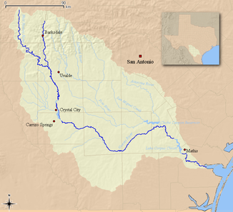
The stream rises northwest of San Antonio on the Edwards Plateau in Real County , about 80 kilometers north of Uvalde . It then flows southwest through the Texas Hill Country region . East of Carrizo Springs , it turns east and flows through South Texas. At Mathis it forms the Lake Corpus Christi reservoir . Then it flows through Corpus Christi and flows into Corpus Christi Bay , a side bay of the Gulf of Mexico .
history
In the Mexican-American War , the Mexicans demanded the area as far as the Nueces River, the Americans as far as the Rio Grande .
On August 10, 1862 , the Nueces River massacre took place here in 1862 , committed by the Southern Cavalry of German-born civil war refugees.

