Central America
In a geographical sense, Central America refers to the land bridge in the middle of the American double continent . Due to its central location, it is partly not included in North America in colloquial terms , but it usually refers to the region in the north of the American double continent. In general, Central America is not seen as a separate continent , but counted as part of North America on the continental level. Along with the West Indies or the Caribbean , which are also ranked among North America, Central America is the region Central America .
Due to the dominant languages brought with them by European colonists and migrants, Central America is regarded as part of Ibero America or Latin America and is designated accordingly.
geography
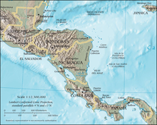
Geographically, Central America begins in the north of the Isthmus of Tehuantepec in southern Mexico , in the south it ranges depending on the definition to the Isthmus of Panama in South panama or to Atratosenke in northwest Colombia . To the east is the Caribbean Sea and to the west the Pacific Ocean .
The delimitation of North America (in the broader sense) and South America is traditionally the Isthmus of Darién , the former Colombian part of the country, now the Panamanian border province, between the Gulf of Darién in the Caribbean and the Gulf of Panama in the Pacific. With the construction of the Panama Canal and the creation of the state of Panama, the name Isthmus of Darien was partly incorporated into the initially synonymous Isthmus of Panama , which also expanded towards the west, partly the Isthmus of Darien also passed to the eastward adjoining depression of the Atrato. Therefore, the demarcation between South America and Central America is given differently.

|
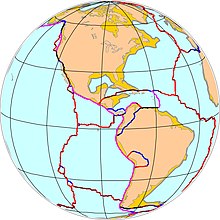
Large tectonic boundaries of the Central American region (plates, convergence, subduction, faults; yellow: continental shelf): North American plate , South American plate , Nazca plate , Pacific plate , sandwiched between the Cocos plate and the Caribbean plate (formation of the Cordillera , the Panama Arc and of the Antilles arc) - illustrates the possible physical-geographic containment concepts.
|
The geological delimitation to North America in the narrower sense would be on the isthmus of Honduras , the oceanographic delimitation is more extensive on the Yucatan peninsula , the delimitation of the Caribbean Sea and the Gulf of Mexico . The isthmus of Tehuantepec west of Yucatan represents the broader term. In addition, there is the socio-cultural concept of Latin or Ibero America, which also includes Central America (Central America in the United States and the Caribbean), which means that the allocation of Mexico is fluctuating.
Depending on whether the areas in Mexico are counted, Central America has between 510,000 km² and 750,000 km².
geology
Geologically, Central America lies largely on the Caribbean plate , and to a lesser extent on the North American plate . Off the Pacific coast in the west , the coconut plate slides under the Caribbean plate , causing volcanism and numerous, often severe, earthquakes .
States
The top six of the seven states named in the table belong geographically completely to Central America. Depending on the geographical definition, the national territory of Panama belongs largely or entirely to it. Mexico is not mentioned in the list because only a small part of the Mexican national territory belongs to Central America.
Guatemala, El Salvador, Honduras, Nicaragua and Costa Rica were already closely connected politically in the past and formed the Central American Confederation after the Spanish colonial rule .
| Country | Area (km²) |
Population (2016) |
Inhabitants per km² |
GDP / inhabitant (US $, 2016) |
Capital |
|---|---|---|---|---|---|
|
|
22,966 | 353.858 | 15th | 4,636 | Belmopan |
|
|
51,100 | 4,872,543 | 95 | 11,835 | San Jose |
|
|
21,041 | 6,156,670 | 293 | 4,343 | San Salvador |
|
|
108,889 | 15.189.958 | 139 | 4,089 | Guatemala City |
|
|
112.090 | 8,893,259 | 79 | 2,609 | Tegucigalpa |
|
|
130,370 | 5,966,798 | 46 | 2.120 | Managua |
|
|
75,420 | 3,705,246 | 49 | 13,654 | Panama City |
| Total | 521.876 | 45.138.332 | 86 | 5,411 |
The northern states of Central America with the exception of Belize, i.e. Guatemala, Honduras and El Salvador, are sometimes combined under the name Triángulo Norte de América Central (TNAC, Spanish North Triangle of Central America ) , especially in migration research . A large part of the Latin American immigrants in the USA come from these countries, so that the name Northern Triangle of Central America (NTCA) has also become naturalized there.
population
Central America has between 40 and 50 million inhabitants, depending on whether the areas in Mexico are included. The largest city in the region is Guatemala City with almost three million inhabitants.
Development of the population (in millions)

Integration of Central America
Since the region gained independence from Spain in 1821, there have been at least 14 attempts at integration.
The Central American Confederation existed between 1823 and 1838 as a confederation of states between the individual states, the culturally integrative echo of which can be seen today in the uniform blue-white-blue national colors of most of the successor states.
Since the 1950s, with a view to European integration and the international models of free trade zones and customs unions, the states have pushed a further integration process in order to relativize dependencies on the world market through joint trade. In the course of these efforts, the Secretariat for the Economic Integration of Central America ( Secretaría de la Integración Económica Centroamericana , SIECA) was set up in 1963, which was supposed to cover the remit of the Agreement on Economic Integration ( Tratado General de Integración Económica Centroamericana ), which came into force in the same year . The treaty created a free trade area for almost all products manufactured in the area. Intra-regional trade grew from $ 6 million in 1963 to $ 2.5 billion in 1999.
The revolutions and civil wars that occurred in Nicaragua, Guatemala and El Salvador at the end of the 1970s brought setbacks for further integration.
See also
literature
- Gerhard Sandner : Central America and the distant Caribbean west. Konjunkturen, Krisen und Konjunkturen, 1503–1984 , Stuttgart (Steiner) 1985. ISBN 3-515-04343-8
Web links
Individual evidence
-
↑ cf. Francis Borland: The History of Darien 1700. onA 1779, p. 7 ( digitized, Google, complete view );
Darien, or Terra Firma Proper. Entry in: Richard Brookes: Brookes's General Gazetteer Improved. Johnson and Warner Verlag, 1812 (above) ( digitized, Google, full view in Google Book Search). - ↑ cf. The Nautical Magazine and Naval Chronicle for 1869. Cambridge Library Collection, onA, p. 265 (New edition Cambridge University Press, 2013, ISBN 9781108054874 ; limited preview in Google Book Search).
- ↑ Jose Xavier Samaniego: Desplazamiento Forzado en el “Triángulo Norte de América Central”: Desafíos en materia de protección . Universidad Centroamericana “José Simeón Cañas” , School of Advanced Study ( University of London ), United Nations High Commissioner for Refugees , San Salvador (El Salvador) 2014, pp. 1–6.
- ↑ United Nations, Department of Economic and Social Affairs: World Population Prospects: The 2010 Revision , data available online
- ^ A b Alvaro de la Ossa: The Central American Integration Process. End of a development alternative, Ibero-American Institute, Preußischer Kulturbesitz Berlin (ed.) (= Ibero-Analyzes), 1st edition, Volume Vol. 6, Ibero-American Institute, Prussian Cultural Heritage Foundation, Berlin 2000, ISBN 978-3-9803291- 9-4 . P. 2.
- ↑ Alvaro de la Ossa: The Central American Integration Process. End of a development alternative . P. 7.
