Río Atrato
| Río Atrato | ||
|
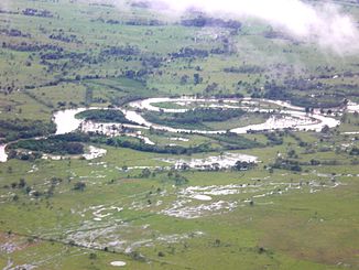
The meandering middle course of the Río Atrato |
||
| Data | ||
| location |
|
|
| River system | Río Atrato | |
| Headwaters | in the Cordillera Occidental 5 ° 53 '40 " N , 76 ° 22' 48" W. |
|
| muzzle | in the Gulf of Urabá coordinates: 8 ° 11 ′ 51 ″ N , 76 ° 55 ′ 26 ″ W 8 ° 11 ′ 51 ″ N , 76 ° 55 ′ 26 ″ W |
|
| Mouth height |
0 m
|
|
| length | approx. 750 km | |
| Catchment area | 38,500 km² | |
| Drain |
MQ |
4900 m³ / s |
| Left tributaries | Río Ipurdú , Río Truandó , Río Salaquí | |
| Right tributaries | Río Murri , Río Sucio | |
| Big cities | Quibdó | |
| Small towns | Lloró , Vigía del Fuerte , Riosucio | |
| Communities | Medio Atrato , El Carmen del Darién | |
| Navigable | 400 km to Quibdó | |
|
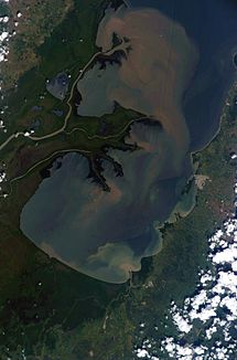
Photo of the Gulf of Urabá from the International Space Station , with the delta of the Río Atrato |
||
The Río Atrato is a river in northwestern Colombia in the transition area from Central America to South America .
course
The river has its source on the slopes of the Cordillera Occidental in Colombia and flows north to the Gulf of Urabá , a bay of the Gulf of Darién , where it forms a large, swampy river delta . The river flows through the Chocó department from south to north and forms the border with the neighboring Antioquia department in two places .
Its length is about 750 km. It is navigable upstream for a length of 400 km to the city of Quibdó . The Atrato pours 4,900 m³ of water into the Caribbean Sea every second . It is said to be the fastest flowing river in the world because the river carries the largest amount of water compared to the size of its catchment area.
On its course through a narrow valley between the Cordillera Occidental in the east and the Serranía de Baudó in the west, the Atrato has only short tributaries, the most important of which are the Río Truandó , the Río Sucio and the Río Murri . Along some of its tributaries are the gold and platinum mines of Chocó and the river sands are gold-bearing. The mining has damaged the nature in the river basin and the indigenous peoples. The Colombian Constitutional Court ruled in November 2016 that the Atrato basin has a right to "protection, conservation, maintenance and restoration".
history
The Atrato was discussed in the past as a route for a Central American canal to pierce the isthmus due to its deep fairway . However, corresponding plans were abandoned in favor of the Panama Canal .
Web links
Individual evidence
- ^ A b Simon Holland, Anna Lofthouse: Rivers and Lakes . Translated by Wiebke Krabbe, editor: Barbara Hörmann. Dorling Kindersley, Starnberg 2003, ISBN 3-8310-0418-8 . P. 13.
- ↑ Press Release: Colombia Constitutional Court Finds Atrato River Possesses Rights. May 4, 2017. Retrieved March 26, 2019 (American English).

