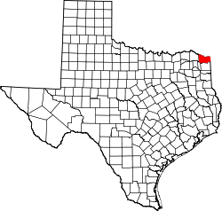
Bowie County
 Bowie County Courthouse |
|
| administration | |
|---|---|
| US state : | Texas |
| Administrative headquarters : | New Boston |
| Address of the administrative headquarters: |
Bowie County Courthouse P.O. Box 248 New Boston, TX 75570-0248 |
| Foundation : | 1840 |
| Made up from: | Red River County |
| Area code : | 001 903 |
| Demographics | |
| Residents : | 92,565 (2010) |
| Population density : | 40.2 inhabitants / km 2 |
| geography | |
| Total area : | 2390 km² |
| Water surface : | 90 km² |
| map | |
| Website : www.co.bowie.tx.us | |
The Bowie County is a county in the US state of Texas . The county seat is in New Boston . The county is part of the Dry Counties , which means that the sale of alcohol is restricted or prohibited.
geography
The county is located in the far northeast of Texas on the south bank of the Red River , which forms the border with Oklahoma . To the west it borders on Arkansas . It has an area of 2390 square kilometers, of which 90 square kilometers are water. The following neighboring counties border Bowie County:
|
McCurtain County, Oklahoma |
Little River County, Arkansas |
|
| Red River County |

|
|
| Morris County | Cass County |
Miller County, Arkansas |
history
Bowie County was formed in 1840 from parts of Red River County. It was named after James Bowie (1796–1836), the legendary knife fighter, killed in the Battle of the Alamo .

Twelve buildings and sites in the county are listed on the National Register of Historic Places (NRHP) (as of October 2, 2018).
Demographic data
| growth of population | |||
|---|---|---|---|
| Census | Residents | ± in% | |
| 1850 | 2912 | - | |
| 1860 | 5052 | 73.5% | |
| 1870 | 4684 | -7.3% | |
| 1880 | 10,965 | 134.1% | |
| 1890 | 20,267 | 84.8% | |
| 1900 | 26,676 | 31.6% | |
| 1910 | 34,827 | 30.6% | |
| 1920 | 39,472 | 13.3% | |
| 1930 | 48,563 | 23% | |
| 1940 | 50.208 | 3.4% | |
| 1950 | 61,966 | 23.4% | |
| 1960 | 59,971 | -3.2% | |
| 1970 | 67,813 | 13.1% | |
| 1980 | 75,301 | 11% | |
| 1990 | 81,665 | 8.5% | |
| 2000 | 90,643 | 11% | |
| 2010 | 92,565 | 2.1% | |
| 1850-2010 | |||
As of the 2010 census , Bowie County had 92,565 people in 34,159 households. The population density was 40.2 people per square kilometer.
The racial the population was composed of 68.8 percent white, 24.2 percent African American, 0.7 percent Native American, 0.8 percent Asian and other ethnic groups; 2.1 percent were descended from two or more races. Regardless of ethnicity, 6.5 percent of the population was Hispanic or Latino of any race. Statistically, 2.56 people lived in each of the 34,159 households.
24.4 percent of the population were under 18 years old, 61.9 percent were between 18 and 64 and 13.7 percent were 65 years or older. 49.4 percent of the population was female.
The median income for a household was 40,634 USD . The per capita income was $ 21,638. 19.8 percent of the population lived below the poverty line.
Protected areas and parks
Bowie County localities
structure
Bowie County is divided into six Census County Divisions (CCD):
| CCD | Population (2010) | FIPS |
|---|---|---|
| Dalby Springs-Simms CCD | 2455 | 48-90950 |
| De Kalb CCD | 5238 | 48-90980 |
| Hooks CCD | 5652 | 48-91830 |
| Maud-Redwater CCD | 10,221 | 48-92476 |
| New Boston CCD | 10,820 | 48-92725 |
| Texarkana CCD | 58.179 | 48-93875 |
See also
Individual evidence
- ↑ Bowie County in the Geographic Names Information System of the United States Geological Survey retrieved 22 February 2011
- ^ National Association of Counties , accessed September 19, 2012
- ↑ Search mask database in the National Register Information System. National Park Service , accessed October 2, 2018.
- ↑ Texas Almanac: Population History of Countys from 1850–2010 (PDF; 698 kB), accessed September 18, 2012
- ^ US Census Bureau, State & County QuickFacts
- ↑ Missouri Census Data Center - Texas ( Memento of the original from December 5, 2012 in the web archive archive.today ) Info: The archive link was automatically inserted and not yet checked. Please check the original and archive link according to the instructions and then remove this notice. , accessed September 19, 2012
Web links
- Official website
- www.city-data.com - Bowie County
- Bowie County in the Handbook of Texas
- "Bowie County Profile" of the Texas Association of Counties
Coordinates: 33 ° 27 ′ N , 94 ° 25 ′ W


