Fisher County
 Fisher County Courthouse |
|
| administration | |
|---|---|
| US state : | Texas |
| Administrative headquarters : | Roby |
| Address of the administrative headquarters: |
Fisher County Courthouse P.O. Box 368 Roby, TX 79543-0368 |
| Foundation : | 1876 |
| Made up from: | Bexar County |
| Area code : | 001 325 |
| Demographics | |
| Residents : | 3974 (2010) |
| Population density : | 1.7 inhabitants / km 2 |
| geography | |
| Total area : | 2336 km² |
| Water surface : | 2 km² |
| map | |
| Website : www.co.fisher.tx.us | |
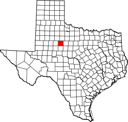
The Fisher County is a county in the state of Texas of the United States . The county seat is in Roby . The county is part of the dry counties , which means that the sale of alcohol is restricted or prohibited.
geography
The county is located northwest of the geographic center of Texas and has an area of 2,336 square kilometers, of which 2 square kilometers are water. It is bordered in a clockwise direction by the following counties: Stonewall County , Jones County , Nolan County , Scurry County, and Kent Counties .
history
Fisher County was formed on August 21, 1876 from parts of Bexar County. The administrative organization was completed on April 27, 1886. It was named after Samuel Rhoads Fisher (1794-1839), a signatory of the Declaration of Independence for the Republic of Texas and its first Secretary of the Navy.
One of the county's sites is listed on the National Register of Historic Places (NRHP) as of May 20, 2019, the Foy Steadman Site .
Demographic data
| growth of population | |||
|---|---|---|---|
| Census | Residents | ± in% | |
| 1880 | 136 | - | |
| 1890 | 2996 | 2,102.9% | |
| 1900 | 3708 | 23.8% | |
| 1910 | 12,596 | 239.7% | |
| 1920 | 11.009 | -12.6% | |
| 1930 | 13,563 | 23.2% | |
| 1940 | 12,932 | -4.7% | |
| 1950 | 11,023 | -14.8% | |
| 1960 | 7865 | -28.6% | |
| 1970 | 6344 | -19.3% | |
| 1980 | 5891 | -7.1% | |
| 1990 | 4842 | -17.8% | |
| 2000 | 4344 | -10.3% | |
| 2010 | 3974 | -8.5% | |
| 1880-2010 | |||
According to the 2000 census , there were 4,344 people in Fisher County; 1,785 households and 1,244 families were counted. The population density was 2 people per square kilometer. The racial the population was composed of 83.75 percent white, 2.76 percent African American, 0.37 percent Native American, 0.14 percent Asian and 11.58 percent from other ethnic groups; 1.40 percent were descended from two or more races. 21.36 percent of the population were Hispanic or Latino of any race.
Of the 1,785 households, 27.6 percent had children or young people living with them. 58.9 percent were married, couples living together, 8.1 percent were single mothers and 30.3 percent were non-families. 28.3 percent were single households and 17.8 percent had people aged 65 years or over. The average household size was 2.39 and the average family size was 2.93 people.
23.9 percent of the population was under 18 years old, 6.3 percent between 18 and 24, 23.0 percent between 25 and 44, 24.1 percent between 45 and 64 and 22.7 percent were 65 years of age or older. The median age was 43 years. For every 100 females there were 92.9 males and for every 100 females age 18 or over there were 89.8 males.
The median income for a household in the city is $ 27,659 , and the median income for a family is $ 34,907. Males had a median income of $ 25,071 versus $ 20,536 for females. The per capita income was $ 15,120. 13.5 percent of families and 17.5 percent of the population lived below the poverty line.
Places in the county
Individual evidence
- ↑ Fisher County in the United States Geological Survey's Geographic Names Information System . Retrieved February 22, 2011
- ↑ Information from the National Association of Counties ( Memento of the original from April 6, 2012 in the Internet Archive ) Info: The archive link was automatically inserted and not yet checked. Please check the original and archive link according to the instructions and then remove this notice. . Retrieved October 10, 2012
- ↑ Charles Curry Aiken, Joseph Nathan Kane: The American Counties: Origins of County Names, Dates of Creation, Area, and Population Data, 1950-2010 . 6th edition. Scarecrow Press, Lanham 2013, ISBN 978-0-8108-8762-6 , p. 101 .
-
↑ Search mask database in the National Register Information System. National Park Service , accessed May 20, 2019.
Weekly List on the National Register Information System. National Park Service , accessed May 20, 2019. - ↑ Texas Almanac: Population History of Countys from 1850–2010 (PDF; 698 kB), accessed September 18, 2012
- ^ Fisher County, Texas , 2000 census datasheet at factfinder.census.gov .
Web links
Coordinates: 32 ° 44 ′ N , 100 ° 24 ′ W


