Gillespie County
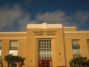
 Gillespie County Courthouse |
|
| administration | |
|---|---|
| US state : | Texas |
| Administrative headquarters : | Fredericksburg |
| Address of the administrative headquarters: |
Gillespie County Courthouse 101 W. Main, Fredericksburg, TX 78624-0551 |
| Foundation : | 1848 |
| Made up from: |
Bexar County Travis County |
| Area code : | 001 830 |
| Demographics | |
| Residents : | 24,837 (2010) |
| Population density : | 9 inhabitants / km 2 |
| geography | |
| Total area : | 2749 km² |
| Water surface : | 1 km² |
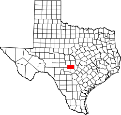
| map | |
| Website : www.gillespiecounty.org | |
The Gillespie County is a county in the state of Texas of the United States . The county seat is in Fredericksburg .
geography
The county is northeast, near the geographic center of Texas, and has an area of 2,749 square kilometers, of which 1 square kilometer is water. It is bordered clockwise by the counties: Llano County , Blanco County , Kendall County , Kerr County , Kimble County, and Mason County . The majority of the county is located at an altitude of 300 to 700 meters above sea level in the Texas Hill Country on the Edwards Plateau , an exception is its northeastern corner, which protrudes into the valley of the Llano River . The soils of the area are loamy, but rarely suitable for arable farming, so 85 percent of the county (2,300 km²) is used as pasture for cattle and sheep breeding .
Near the town of Stonewall is the birthplace and former farm of Lyndon B. Johnsons , 36th President of the United States; the grounds of the farm form part of the Lyndon B. Johnson National Historical Park , as well as the "Lyndon B. Johnson State Historical Park".
history
Tonkawa originally lived in the area of the county before settlers of European descent were first settled , later Comanche and Kiowas were added, before around 140 German settlers organized in the Mainz Aristocracy Association founded the first settlement with Fredricksburg in 1846 . This applied in December 1847 to the state of Texas to establish a new county, which was formed under the current name on February 23, 1848 from parts of Bexar County and Travis County. The administrative organization was completed on June 3 of the same year. It was named after Robert Addison Gillespie (1815-1846), an officer in the Mexican-American War who fell at the Battle of Monterrey .
In 1858, today's Mason and Blanco Counties were spun off from the Gillespies area. The county was largely determined by German Lutheran settlers in the first few decades . In 1850, 913 of the 1,235 adult male residents were of German descent. At the beginning of the Civil War they voted almost unanimously against Texas leaving the Union, whereupon the county and its neighboring areas were placed under martial law .
First Sheriff Gillespie County was the 1844 Texas emigrated, at that time 24-year-old businessman from Erndtebrück Ludwig (Louis) Martin (* 25 November 1820; † 18 June 1864). As such he worked until 1851. He was ambushed by mercenaries of the Southern Army on June 18, 1864 on a return trip from Mexico and hanged from a tree. Ludwig Martin, the uncle of America's first female bank president Anna Martin , was the founder of the Mason County town of Hedwigs Hill , which he named after his mother and daughter, both of whom were given the first name Hedwig.
In 1908 the future US President Lyndon B. Johnson was born in Stonewall , a town in Gillespie County.
20 buildings and sites in the county are listed on the National Register of Historic Places (NRHP) (as of May 29, 2019). The county has a National Historic Landmark , the Ha. 19 Japanese Midget Attack Submarine .
Demographic data
| growth of population | |||
|---|---|---|---|
| Census | Residents | ± in% | |
| 1850 | 1240 | - | |
| 1860 | 2736 | 120.6% | |
| 1870 | 3566 | 30.3% | |
| 1880 | 5228 | 46.6% | |
| 1890 | 7056 | 35% | |
| 1900 | 8229 | 16.6% | |
| 1910 | 9447 | 14.8% | |
| 1920 | 10,015 | 6% | |
| 1930 | 11,020 | 10% | |
| 1940 | 10,670 | -3.2% | |
| 1950 | 10,520 | -1.4% | |
| 1960 | 10,048 | -4.5% | |
| 1970 | 10,553 | 5% | |
| 1980 | 13,532 | 28.2% | |
| 1990 | 17.204 | 27.1% | |
| 2000 | 20,814 | 21% | |
| 2010 | 24,837 | 19.3% | |
| 1850-2010 | |||

As of the 2000 census , Gillespie County had 20,814 people in 8,521 households and 6,083 families. The population density was 8 people per square kilometer. The racial the population was composed of 92.82 percent white, 0.21 percent African American, 0.33 percent Native American, 0.18 percent Asian, 0.02 percent of residents from the Pacific island area and 5.27 percent from other ethnic groups Groups; 1.18 percent were from two or more races. 15.9 percent of the population were Hispanic or Latino of any race.
Of the 8,521 households, 25.9 percent had children or young people living with them. 62.1 percent were married couples living together, 7 percent were single mothers, and 28.6 percent were non-families. 25.8 percent were single households and 14.2 percent had people aged 65 years or over. The average household size was 2.38 and the average family size was 2.84 people.
21.6 percent of the population was under 18 years old, 5.5 percent between 18 and 24, 21.20 percent between 25 and 44, 26.2 percent between 45 and 64 and 25.5 percent were 65 years of age or older. The median age was 46 years. For every 100 females there were 89.7 males and for every 100 females age 18 or over there were 88.1 males.
The median income for a household in the city is $ 38,109 , and the median income for a family is $ 45,315. Males had a median income of $ 26,675 versus $ 20,918 for females. The per capita income was $ 20,423. 10.2 percent of the population and 7.1 percent of families lived below the poverty line.
Places in the county
Protected areas
See also
- Texas German
- Nueces River massacre, 1862
- List of entries on the National Register of Historic Places in Gillespie County
literature
- Martin Donell Kohout: Gillespie County. In: The Handbook of Texas Online. Texas State Historical Association (TSHA), 1999 ff (English, tshaonline.org ).
Web links
- Texas Association of Counties Gillespie County Profile
Individual evidence
- ↑ Gillespie County in the United States Geological Survey's Geographic Names Information System . Retrieved February 22, 2011
- ↑ Information from the National Association of Counties ( Memento of the original from January 25, 2012 in the Internet Archive ) Info: The archive link was inserted automatically and has not yet been checked. Please check the original and archive link according to the instructions and then remove this notice. . Retrieved October 10, 2012
- ^ A b Martin Donell Kohout: Gillespie County. In: The Handbook of Texas Online. Texas State Historical Association (TSHA), 1999 ff (English, tshaonline.org ). Online edition 1999 ff.
- ↑ 573,000 acres to Kohout
- ^ A b Christopher Long: Lyndon B. Johnson National Historical Park. In: The Handbook of Texas Online. Texas State Historical Association (TSHA), 1999 ff (English, tshaonline.org ). Online edition 1999 ff.
- ↑ Charles Curry Aiken, Joseph Nathan Kane: The American Counties: Origins of County Names, Dates of Creation, Area, and Population Data, 1950-2010 . 6th edition. Scarecrow Press, Lanham 2013, ISBN 978-0-8108-8762-6 , p. 113 .
- ↑ When they were hanging Louis ... in Siegener Zeitung of January 16, 2012, p. 9
-
↑ Search mask database in the National Register Information System. National Park Service , accessed May 29, 2019.
Weekly List on the National Register Information System. National Park Service , accessed May 29, 2019. - ↑ Listing of National Historic Landmarks by State: Texas. National Park Service , accessed May 29, 2019.
- ↑ Texas Almanac: Population History of Countys from 1860–2010 (PDF; 698 kB), accessed September 18, 2012
- ↑ a b Extract from the National Register of Historic Places . Retrieved March 13, 2011
- ↑ Gillespie County, Texas , 2000 census data sheet at factfinder.census.gov .
Coordinates: 30 ° 19 ′ N , 98 ° 57 ′ W


