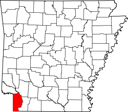
Miller County, Arkansas
 Miller County Courthouse |
|
| administration | |
|---|---|
| US state : | Arkansas |
| Administrative headquarters : | Texarkana |
| Address of the administrative headquarters: |
County Courthouse 400 Laurel Street Texarkana, AR 71854-5249 |
| Foundation : | April 1, 1820 / December 22, 1874 |
| Made up from: | Lafayette County |
| Area code : | 001 870 |
| Demographics | |
| Residents : | 43,462 (2010) |
| Population density : | 26.9 inhabitants / km 2 |
| geography | |
| Total area : | 1651 km² |
| Water surface : | 35 km² |
| map | |
| Website : www.millercountyar.org | |
The Miller County is a county in the US state of Arkansas . The county seat is Texarkana .
geography
The county is located in the extreme southwest of Arkansas, borders Louisiana to the south and Texas to the west and covers an area of 1,651 square kilometers, of which 35 square kilometers are water. It is bordered by the following counties and parishes:
| Little River County | Hempstead County | |
|
Bowie County, Texas |

|
Lafayette County |
|
Cass County, Texas |
Caddo Parish (Louisiana) |
Bossier Parish (Louisiana) |
history
| growth of population | |||
|---|---|---|---|
| Census | Residents | ± in% | |
| 1820 | 999 | - | |
| 1830 | 356 | -64.4% | |
| 1880 | 9919 | - | |
| 1890 | 14,714 | 48.3% | |
| 1900 | 17,558 | 19.3% | |
| 1910 | 19,555 | 11.4% | |
| 1920 | 24,021 | 22.8% | |
| 1930 | 30,586 | 27.3% | |
| 1940 | 31,874 | 4.2% | |
| 1950 | 32,614 | 2.3% | |
| 1960 | 31,686 | -2.8% | |
| 1970 | 33,385 | 5.4% | |
| 1980 | 37,766 | 13.1% | |
| 1990 | 38,467 | 1.9% | |
| 2000 | 40,443 | 5.1% | |
| 2010 | 43,462 | 7.5% | |
| 1820-1890 1900-1990
2000 2010 |
|||
Miller County was first formed on April 1, 1820 and dissolved again in 1838. In 1820, the county essentially comprised what is now the area plus other areas in Texas. The first county seat was in John Hall House in Gilliland .
Preserving the county was not feasible at the time, as Mexico ruled most of East Texas and Texas did not declare its independence from Mexico until 1836, after the Texan War of Independence , and proclaimed the Republic of Texas . This republic was never recognized by the Mexican government. It was not until the Mexican - American War (1846–1848) that the "Texan question" was resolved.
On December 22, 1874, Miller County was formed again from parts of Lafayette County. It is named after each James Miller (1776-1851), the first governor of Arkansas - territory (1819-1825).
Demographic data
According to the 2010 census , Miller County had 43,462 people in 16,600 households. The population density was 26.9 inhabitants per square kilometer.
The racial the population was composed of 71.6 percent white, 24.5 percent African American, 0.7 percent Native American, 0.5 percent Asian and other ethnic groups; 1.7 percent were descended from two or more races. Hispanic or Latino of any race was 2.4 percent of the population.
Statistically, 2.51 people lived in each of the 16,600 households.
23.9 percent of the population were under 18 years old, 61.8 percent were between 18 and 64 and 14.3 percent were 65 years or older. 51.2 percent of the population was female.
The median income for a household was 38,855 USD . The per capita income was $ 19,445. 19.0 percent of the population lived below the poverty line.
Places in Miller County
- other places
Individual evidence
- ↑ GNIS-ID: 69166. Retrieved on February 22, 2011 (English).
- ^ National Association of Counties.Retrieved October 4, 2011
- ^ US Census Bureau _ Census of Population and Housing.Retrieved February 17, 2011
- ^ Extract from Census.gov.Retrieved February 15, 2011
- ↑ census.gov (2000) ( Memento of the original from September 24, 2015 in the Internet Archive ) Info: The archive link was inserted automatically and has not yet been checked. Please check the original and archive link according to the instructions and then remove this notice. ( MS Excel ; 27 kB) Retrieved March 31, 2012
- ↑ United States Census 2010.Retrieved October 4, 2011
- ^ Extract from the Encyclopedia of Arkansas.Retrieved February 13, 2011
- ↑ US Census Bureau, State & County QuickFacts - Miller County ( Memento of the original from July 14, 2011 on WebCite ) Info: The archive link was automatically inserted and not yet checked. Please check the original and archive link according to the instructions and then remove this notice. Retrieved October 4, 2011
Web links
- US Census Bureau, State & County QuickFacts - Miller County
- Yahoo Image Search - Miller County
- www.city-data.com - Miller County
- Association of Arkansas Counties
Coordinates: 33 ° 20 ′ N , 93 ° 53 ′ W


