Randolph County, Arkansas
![Randolph County Courthouse, listed on the NRHP since 1996 [1]](https://upload.wikimedia.org/wikipedia/commons/thumb/4/48/Randolph_County_Arkansas_Courthouse.jpg/298px-Randolph_County_Arkansas_Courthouse.jpg) Randolph County Courthouse, listed on the NRHP since 1996 |
|
| administration | |
|---|---|
| US state : | Arkansas |
| Administrative headquarters : | Pocahontas |
| Address of the administrative headquarters: |
County Courthouse 107 West Broadway Pocahontas, AR 72455 |
| Foundation : | October 29, 1835 |
| Made up from: | Lawrence County |
| Area code : | 001 870 |
| Demographics | |
| Residents : | 17,969 (2010) |
| Population density : | 10.6 inhabitants / km 2 |
| geography | |
| Total area : | 1699 km² |
| Water surface : | 11 km² |
| map | |
The Randolph County is a county in the US -amerikanischen State Arkansas . In 2010 , the county had 17,969 residents and a population density of 10.6 people per square kilometer. The county seat is Pocahontas . The county is part of the dry counties , which means that the sale of alcohol is restricted or prohibited.

geography
The county is located in northeast Arkansas and borders Missouri to the north . It has an area of 1,699 square kilometers, of which eleven square kilometers are water. The county is traversed by the Black River , a left tributary of the White River . The following neighboring counties border Randolph County:
|
Oregon County, Missouri |
Ripley County, Missouri |
|
| Sharp County |

|
Clay County |
| Lawrence County | Greene County |
history
Randolph County was formed on October 29, 1835 from parts of Lawrence County. It was named after John Randolph of Roanoke (1773-1833), a US - Senator from Virginia , who claimed, a descendant of the Indian princess Pocahontas to be.
Demographic data
| Population development | |||
|---|---|---|---|
| Census | Residents | ± in% | |
| 1840 | 2196 | - | |
| 1850 | 3275 | 49.1% | |
| 1860 | 6261 | 91.2% | |
| 1870 | 7466 | 19.2% | |
| 1880 | 11,724 | 57% | |
| 1890 | 14,485 | 23.5% | |
| 1900 | 17,156 | 18.4% | |
| 1910 | 18,987 | 10.7% | |
| 1920 | 17,713 | -6.7% | |
| 1930 | 16,871 | -4.8% | |
| 1940 | 18,319 | 8.6% | |
| 1950 | 15,982 | -12.8% | |
| 1960 | 12,520 | -21.7% | |
| 1970 | 12,645 | 1 % | |
| 1980 | 16,834 | 33.1% | |
| 1990 | 16,558 | -1.6% | |
| 2000 | 18.195 | 9.9% | |
| 2010 | 17,969 | -1.2% | |
| 1840-1890 1900-1990 2000 2010 | |||

According to the 2010 census , Randolph County had 17,969 people in 7255 households. The population density was 10.6 inhabitants per square kilometer. In the 7255 households there were statistically 2.45 people each.
The racial the population was composed of 96.9 percent white, 1.0 percent African American, 0.6 percent Native American, 0.2 percent Asian and other ethnic groups; 1.3 percent were descended from two or more races. Hispanic or Latino of any race was 1.7 percent of the population.
23.0 percent of the population were under 18 years old, 58.4 percent were between 18 and 64 and 18.6 percent were 65 years or older. 51.0 percent of the population was female.
The median income for a household was 30,222 USD . The per capita income was $ 18,751. 19.7 percent of the population lived below the poverty line.
Randolph County localities
structure
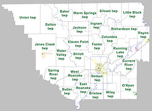
Randolph County is divided into 26 townships :
|
|
See also
Individual evidence
- ↑ Extract from the National Register of Historic Places - No. 96000910. Retrieved August 30, 2011
- ↑ GNIS-ID: 69178. Retrieved on February 22, 2011 (English).
- ↑ a b c U.S. Census Bureau, State & County QuickFacts - Randolph County, AR Retrieved October 2, 2012
- ^ A b National Association of Counties.Retrieved October 2, 2012
- ↑ Extract from the National Register of Historic Places - No. 73000390.Retrieved August 30, 2011
- ^ Extract from the Encyclopedia of Arkansas.Retrieved February 13, 2011
- ^ US Census Bureau _ Census of Population and Housing.Retrieved February 17, 2011
- ^ Extract from Census.gov.Retrieved February 15, 2011
- ↑ Missouri Census Data Center - Arkansas ( page no longer available , search in web archives ) Info: The link was automatically marked as defective. Please check the link according to the instructions and then remove this notice. Retrieved October 2, 2012
Web links
- Randolph County Chamber of Commerce
- www.city-data.com - Randolph County
- Association of Arkansas Counties
Coordinates: 36 ° 21 ′ N , 91 ° 1 ′ W


