Garland County
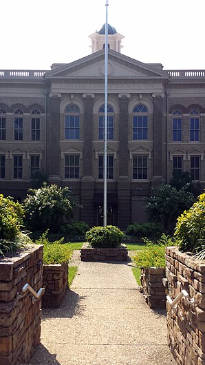
 Garland County Courthouse |
|
| administration | |
|---|---|
| US state : | Arkansas |
| Administrative headquarters : | Hot springs |
| Address of the administrative headquarters: |
County Courthouse 501 Ouachita Avenue Hot Springs, AR 71901-5154 |
| Foundation : | April 5, 1873 |
| Made up from: | Saline County |
| Area code : | 001 501 |
| Demographics | |
| Residents : | 96,024 (2010) |
| Population density : | 54.7 inhabitants / km 2 |
| geography | |
| Total area : | 1903 km² |
| Water surface : | 149 km² |
| map | |
| Website : www.garlandcounty.org | |
The Garland County is a county in the US state of Arkansas . At the 2010 census , the county had 96,024 people and a population density of 54.7 people per square kilometer. The county seat is Hot Springs .
geography
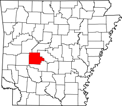
The county is west of the geographic center of Arkansas and has an area of 1903 square kilometers, of which 149 square kilometers are water. It borders on the following counties:
| Yell County | Perry County | |
| Montgomery County |

|
Saline County |
| Hot Spring County |
history
Garland County was formed on April 5, 1873 from parts of Saline County. It was named after Augustus Hill Garland , an Arkansas governor, US senator, and attorney general.
The first settlers: As early as 1807, Jean Pierre Emanuel Prudhomme , the ailing owner of a plantation on the Red River, heard about the hot medicinal water from Indians. He built the first real settlement near the springs and lived there for two years. Isaac Cates and John Percival, two trappers from Alabama, joined him. Cates was primarily a trapper, but Percival envisioned a bright future for the area and built log houses to rent out to the springs' increasing numbers of visitors.
In 1828 Ludovicus Belding came with his wife and children to visit the hot springs. After a few months he built a small hotel for visitors to the springs.
Demographic data
| growth of population | |||
|---|---|---|---|
| Census | Residents | ± in% | |
| 1880 | 9023 | - | |
| 1890 | 15,328 | 69.9% | |
| 1900 | 18,773 | 22.5% | |
| 1910 | 27,271 | 45.3% | |
| 1920 | 25,785 | -5.4% | |
| 1930 | 36,031 | 39.7% | |
| 1940 | 41,664 | 15.6% | |
| 1950 | 47.102 | 13.1% | |
| 1960 | 46,697 | -0.9% | |
| 1970 | 54,131 | 15.9% | |
| 1980 | 70,531 | 30.3% | |
| 1990 | 73.397 | 4.1% | |
| 2000 | 88,068 | 20% | |
| 2010 | 96,024 | 9% | |
| 1880-1890 1900-1990
2000 2010 |
|||
Garland County's population was 88,068 as of the 2000 census . 1,861 of these people lived in collective accommodation, the other residents lived in 37,813 households and 25,259 families. The population density was 50 inhabitants per square kilometer. The racial the population was composed of 88.85 percent white, 7.80 percent African American, 0.61 percent Native American, 0.50 percent Asian, 0.03 percent from the Pacific island area and 0.72 percent from other ethnic groups Groups; 1.49 percent are descended from two or more races. Hispanic or Latino of any of the above mentioned groups were 2.56 percent of the population.
Of the 37,813 households, 25.1 percent had children or adolescents under the age of 18 living with them. 53.2 percent were married couples living together, 10.1 percent were single mothers, 33.2 percent were non-families. 28.8 percent of all households were single households and 13.5 percent had people aged 65 or over. The average household size was 2.28 and the average family size was 2.78 people.
21.3 percent of the population were under 18 years old, 7.3 percent between 18 and 24, 25.2 percent between 25 and 44, 25.1 percent between 45 and 64 and 21.2 percent were 65 years or older. The median age was 42 years. Statistically, there were 94.4 males for every 100 females and an average of 90.8 males for every 100 females aged 18 and over.
The median income for a household in the county is $ 31,724 , and the median income for a family is $ 38,079 . Males had a median income of $ 28,117 versus $ 20,421 for females. The per capita income was $ 18,631. 10.5 percent of families and 14.6 percent of the population lived below the poverty line.
Places in Garland County
|
Census-designated places (CDP) |
|
1 - partly in Saline County other places
Individual evidence
- ↑ GNIS-ID: 66855. Retrieved on February 22, 2011 (English).
- ^ Extract from the Encyclopedia of Arkansas . Retrieved February 12, 2011
- ^ US Census Bureau _ Census of Population and Housing - Retrieved February 17, 2011
- ^ Extract from Census.gov.Retrieved February 15, 2011
- ↑ census.gov (2000) ( Memento of the original from September 24, 2015 in the Internet Archive ) Info: The archive link was inserted automatically and has not yet been checked. Please check the original and archive link according to the instructions and then remove this notice. ( MS Excel ; 27 kB) Retrieved March 31, 2012
- ↑ United States Census 2010.Retrieved July 14, 2011
- ↑ Garland County, Arkansas data sheet with the results of the 2000 census at factfinder.census.gov
Web links
Coordinates: 34 ° 35 ′ N , 93 ° 8 ′ W


