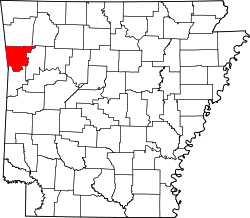
Crawford County, Arkansas
 Crawford County Courthouse |
|
| administration | |
|---|---|
| US state : | Arkansas |
| Administrative headquarters : | Van Buren |
| Address of the administrative headquarters: |
County Courthouse 300 Main Street Van Buren, AR 72956-5765 |
| Foundation : | October 18, 1820 |
| Made up from: | Pulaski County |
| Area code : | 001 479 |
| Demographics | |
| Residents : | 61,948 (2010) |
| Population density : | 40.2 inhabitants / km 2 |
| geography | |
| Total area : | 1565 km² |
| Water surface : | 23 km² |
| map | |
| Website : www.crawford-county.org | |
The Crawford County is a county in the US state of Arkansas . The county seat is Van Buren . The county is part of the dry counties , which means that the sale of alcohol is restricted or prohibited.
geography
The county is located in northwest Arkansas, bordering Oklahoma to the west and has an area of 1,565 square kilometers, of which 23 square kilometers are water. It borders on the following counties:
|
Adair County, Oklahoma |
Washington County | Madison County |
|
Sequoyah County, Oklahoma |

|
Franklin County |
|
Le Flore County, Oklahoma |
Sebastian County |
history
Crawford County was formed on October 18, 1820 from parts of Pulaski County and in 1820 was the largest county in Arkansas.
It was named after William Harris Crawford (1772-1834), a US Secretary of War (1815-1816) and Treasury Secretary (1816-1825)
In the period that followed, eight more counties and an Indian reservation emerged from Crawford County. The first newspaper, the Arkansas Intelligencer , was published in 1842. The first telegraph connection was laid in 1851 and the Butterfield Overland Mail's first stagecoach ran from September 1858.
Demographic data
| growth of population | |||
|---|---|---|---|
| Census | Residents | ± in% | |
| 1830 | 2440 | - | |
| 1840 | 4266 | 74.8% | |
| 1850 | 7960 | 86.6% | |
| 1860 | 7850 | -1.4% | |
| 1870 | 8957 | 14.1% | |
| 1880 | 14,740 | 64.6% | |
| 1890 | 21,714 | 47.3% | |
| 1900 | 21,270 | -2% | |
| 1910 | 23,942 | 12.6% | |
| 1920 | 25,739 | 7.5% | |
| 1930 | 22,549 | -12.4% | |
| 1940 | 23,920 | 6.1% | |
| 1950 | 22,727 | -5% | |
| 1960 | 21,318 | -6.2% | |
| 1970 | 25,677 | 20.4% | |
| 1980 | 36,892 | 43.7% | |
| 1990 | 42,493 | 15.2% | |
| 2000 | 53,247 | 25.3% | |
| 2010 | 61,948 | 16.3% | |
| 1830-1890 1900-1990 2010 | |||

According to the 2010 census , Crawford County had 61,948 people in 21,350 households. The population density was 40.2 people per square kilometer.
The racial the population was composed of 89.1 percent white, 1.2 percent African American, 2.2 percent Native American, 1.4 percent Asian and other ethnic groups; 2.9 percent were descended from two or more races. Hispanic or Latino of any race was 6.1 percent of the population.
Statistically, there were 2.74 people each in the 21,350 households.
26.4 percent of the population were under 18 years old, 60.9 percent were between 18 and 64 and 12.7 percent were 65 years or older. 50.6 percent of the population was female.
The median income for a household was 39,618 USD . The per capita income was $ 18,637. 17.6 percent of the population lived below the poverty line.
Places in Crawford County
|
|
- other places
- Artist Point
- Barcelona
- Cain
- Catcher
- Concord
- Cross lanes
- Davidson
- Deans Market
- Dripping Springs
- Figure Five
- Furry
- Graphic
- Greenwood Junction
- Haroldton
- Hobbtown
- Lee Creek
- Meadows
- Mount Gaylor
- Natural Dam
- New Haroldton
- New Town
- Oak Grove
- Pleasant Hill
- Rena
- Schaberg
- Shibley
- Smeltzer
- Westville
- Wright Town
- Yoestown
- Alma Township
- Bidville Township
- Cedar Creek Township
- Cedarville Township
- Chester Township
- Cove City Township
- Dean Springs Township
- Dora Township
- Dyer Township
- Jasper Township
- Kibler Township
- Lancaster Township
- Lees Creek Township
- Locke Township
- Mountainburg Township
- Mulberry Township
- Oliver Springs Township
- Porter Township
- Rudy Township
- Uniontown Township
- Upper Township
- Van Buren Township
- Vine Prairie Township
- Whitley Township
- Winfrey Township
Individual evidence
- ↑ GNIS-ID: 69161. Retrieved on February 22, 2011 (English).
- ^ Extract from the Encyclopedia of Arkansas.Retrieved February 12, 2011
- ^ US Census Bureau _ Census of Population and Housing.Retrieved February 17, 2011
- ^ Extract from Census.gov.Retrieved February 15, 2011
- ↑ United States Census 2010.Retrieved September 8, 2011
- ↑ Extract from the National Register of Historic Places - No. 96000461. Retrieved September 8, 2011
- ↑ Extract from the National Register of Historic Places - No. 76000402. Retrieved September 8, 2011
- ^ US Census Bureau, State & County QuickFacts - Crawford County. Retrieved September 8, 2011
Web links
- Official website
- US Census Bureau, State & County QuickFacts - Crawford County
- Yahoo Image Search - Crawford County
- www.city-data.com - Crawford County
- Association of Arkansas Counties
Coordinates: 35 ° 34 ′ N , 94 ° 15 ′ W


