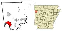
Van Buren (Arkansas)
|
|
This article was on the basis of substantive defects quality assurance side of the project USA entered. Help bring the quality of this article to an acceptable level and take part in the discussion ! A closer description on the resolving issues is missing. |
| Van Buren | |
|---|---|
 Main Street |
|
| Location in Arkansas | |
| Basic data | |
| Foundation : | 1831 |
| State : | United States |
| State : | Arkansas |
| County : | Crawford County |
| Coordinates : | 35 ° 27 ′ N , 94 ° 21 ′ W |
| Time zone : | Central ( UTC − 6 / −5 ) |
|
Inhabitants : - Metropolitan Area : |
21,249 (as of 2006) 273,170 (as of 2006) |
| Population density : | 544.8 inhabitants per km 2 |
| Area : | 41.1 km 2 (approx. 16 mi 2 ) of which 39.0 km 2 (approx. 15 mi 2 ) are land |
| Height : | 122 m |
| Postcodes : | 72956-72957 |
| Area code : | +1 479 |
| FIPS : | 05-71480 |
| GNIS ID : | 0078647 |
| Website : | www.vanburencity.org |
| Mayor : | Bob Freeman |
Van Buren is a city in Crawford County in the US -amerikanischen State Arkansas with 20,400 inhabitants ( 2004 ) and the seat of the county administration. The urban area has a size of 41.1 km².
history
On January 4, 1845, Van Buren officially received local self-government .
The city was named after Martin Van Buren , the 8th President of the United States . The Battle of Van Buren took place on December 28, 1862. In this defeated Union troops led by Major General Samuel Ryan Curtis a unit of the Confederate.
On April 21, 1996, the Fort Smith / Van Buren area was hit by a severe hurricane .
geography
Van Buren is north of Fort Smith, Arkansas , USA.
sons and daughters of the town
- Bob Burns , entrepreneur, radio comedian, and film actor
| Population development | |||
|---|---|---|---|
| Census | Residents | ± in% | |
| 1870 | 985 | - | |
| 1880 | 1029 | 4.5% | |
| 1890 | 2291 | 122.6% | |
| 1900 | 2573 | 12.3% | |
| 1910 | 3878 | 50.7% | |
| 1920 | 5224 | 34.7% | |
| 1930 | 5182 | -0.8% | |
| 1940 | 5422 | 4.6% | |
| 1950 | 6413 | 18.3% | |
| 1960 | 6787 | 5.8% | |
| 1970 | 8373 | 23.4% | |
| 1980 | 12,020 | 43.6% | |
| 1990 | 14,979 | 24.6% | |
| 2000 | 18,986 | 26.8% | |
| 1870-2000 | |||
Individual evidence
- ^ Extract from the Encyclopedia of Arkansas . Retrieved February 13, 2011

