Texarkana, Arkansas
| Texarkana | |
|---|---|
 Border marker at the courthouse |
|
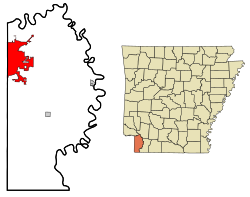
| Location in county and Arkansas | |
| Basic data | |
| Foundation : | August 10, 1880 |
| State : | United States |
| State : | Arkansas |
| County : | Miller County |
| Coordinates : | 33 ° 26 ′ N , 94 ° 1 ′ W |
| Time zone : | Central ( UTC − 6 / −5 ) |
| Residents : | 29,919 (as of 2010) |
| Population density : | 362.7 inhabitants per km 2 |
| Area : | 83.0 km 2 (approx. 32 mi 2 ) of which 82.5 km 2 (approx. 32 mi 2 ) are land |
| Height : | 110 m |
| Postal code : | 71854 |
| Area code : | +1 870 |
| FIPS : | 05-68810 |
| GNIS ID : | 0078542 |
| Website : | www.txkusa.org/ar |
| Mayor : | Horace G. Shipp |
Texarkana is a city in Miller County on the border between the US states of Arkansas and Texas with 29,919 inhabitants (as of 2010 ) and the administrative seat of Miller County. The city extends over an area of 83 km².
On the other side of the border is the sister city of Texarkana, Texas . Both cities are administratively separate, but in many ways form a unit. The name of the city was formed from the states of Tex as, Ark ansas and Louisi ana .
Population development
| Population development | |||
|---|---|---|---|
| Census | Residents | ± in% | |
| 1880 | 1390 | - | |
| 1890 | 3528 | 153.8% | |
| 1900 | 4914 | 39.3% | |
| 1910 | 5655 | 15.1% | |
| 1920 | 8257 | 46% | |
| 1930 | 10,764 | 30.4% | |
| 1940 | 11,821 | 9.8% | |
| 1950 | 15,875 | 34.3% | |
| 1960 | 19,788 | 24.6% | |
| 1970 | 21,682 | 9.6% | |
| 1980 | 21,459 | -1 % | |
| 1990 | 22,631 | 5.5% | |
| 2000 | 26,448 | 16.9% | |
| 2010 | 29,919 | 13.1% | |
| 1880-2010 | |||
sons and daughters of the town
- Jasper Taylor (1894–1964), jazz musician
- Walter E. Rogers (1908–2001), politician, member of the US House of Representatives
- Conlon Nancarrow (1912–1997), Mexican composer of American origin
- Jack B. Sowards (1929–2007), screenwriter, film producer and film actor
- Parnelli Jones (* 1933), car racing driver and racing team owner
- Robert Dwayne Gruss (* 1955), Roman Catholic Bishop of Saginaw
- Dana Kimmell (born 1959), actress
- Mike Ross (* 1961), politician, member of the House of Representatives
- Dustin Moseley (* 1981), major league baseball player
- Taylor Wilson (* 1994), student
Individual evidence
- ^ Extract from the Encyclopedia of Arkansas . Retrieved February 13, 2011
Web link
Commons : Texarkana - collection of images, videos and audio files
