Baxter County
![The Baxter County Courthouse in Mountain Home, listed on the NRHP since 1995 [1]](https://upload.wikimedia.org/wikipedia/commons/thumb/f/f3/Baxter_County_Arkansas_Courthouse.JPG/298px-Baxter_County_Arkansas_Courthouse.JPG) The Baxter County Courthouse in Mountain Home, listed on the NRHP since 1995 |
|
| administration | |
|---|---|
| US state : | Arkansas |
| Administrative headquarters : | Mountain Home |
| Address of the administrative headquarters: |
Baxter County Courthouse 1 East Seventh Street Mountain Home, AR 72653 |
| Foundation : | March 24, 1873 |
| Made up from: |
Fulton County Izard County Marion County Searcy County |
| Area code : | 001 870 |
| Demographics | |
| Residents : | 41,513 (2010) |
| Population density : | 28.9 inhabitants / km 2 |
| geography | |
| Total area : | 1520 km² |
| Water surface : | 84 km² |
| map | |
| Website : www.baxtercounty.org | |
The Baxter County is a county in the US state of Arkansas . The county seat is Mountain Home .
geography
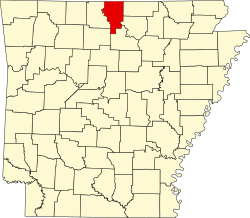
The county is located in the far north of Arkansas, borders Missouri to the north and has an area of 1,520 square kilometers, of which 84 square kilometers are water. It borders on the following counties:
|
Ozark County, Missouri |
||
| Marion County |

|
Fulton County |
| Searcy County | Stone County | Izard County |
history
Baxter County was formed on March 24, 1873 from parts of Fulton County, Izard County, Marion County, and Searcy Counties. It was named after Elisha Baxter (1827–1899), the tenth governor of Arkansas (1872–1874).
The final county boundaries were set in 1881.
From 1850 steamers sailed the White River and served the transport of people and goods. Around 1900, with the construction of the railway bridge at Cotter , the railway took over this task.
The Jacob Wolf House , a two-story log cabin, in Liberty (now Norfork) served as the territorial administrative headquarters from 1828 to 1836. The Wolf House is the oldest surviving courthouse in Arkansas.
Demographic data
| growth of population | |||
|---|---|---|---|
| Census | Residents | ± in% | |
| 1880 | 6004 | - | |
| 1890 | 8527 | 42% | |
| 1900 | 9298 | 9% | |
| 1910 | 10,389 | 11.7% | |
| 1920 | 10,216 | -1.7% | |
| 1930 | 9519 | -6.8% | |
| 1940 | 10,281 | 8th % | |
| 1950 | 11,683 | 13.6% | |
| 1960 | 9943 | -14.9% | |
| 1970 | 15,319 | 54.1% | |
| 1980 | 27,409 | 78.9% | |
| 1990 | 31,186 | 13.8% | |
| 2000 | 38,386 | 23.1% | |
| 2010 | 41,513 | 8.1% | |
| 1880-1890 1900-1990, 2010 | |||


Baxter County's population was 38,386 as of the 2000 census . 710 of them lived in collective accommodation, the other residents lived in 17,052 households and 11,799 families. The population density was 27 people per square kilometer. The racial the population was composed of 97.81 percent white, 0.11 percent African American, 0.52 percent Native American, 0.34 percent Asian, 0.02 percent of residents from the Pacific island area and 0.22 percent from other ethnic groups Groups; 0.97 percent are descended from two or more races. Hispanic or Latino of any race was 1.00 percent of the population.
Of the 17,052 households, 22.0 percent had children or adolescents under the age of 18 living with them. 59.0 percent were married couples living together, 7.7 percent were single mothers, and 30.8 percent were non-families. 27.5 percent of all households were single households and 15.1 percent had people aged 65 or over. The average household size was 2.21 and the average family size was 2.65.
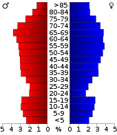
19.0 percent of the population were under 18 years old, 5.8 percent between 18 and 24, 21.1 percent between 25 and 44, 27.4 percent between 45 and 64 and 26.8 percent were 65 years or older. The mean age was 48 years. For every 100 females there were statistically 92.3 males and for every 100 females aged 18 and over there was an average of 89.1 males.
The median income for a household in the 29,106 USD , and the median income for a family 34,578 USD. Males had a median income of $ 25,976 versus $ 18,923 for females. The per capita income was $ 16,859. 7.9 percent of families and 11.1 percent of the population lived below the poverty line.
Places in Baxter County
1 - partially in Searcy County
- other places
See also
Web links
- Official website
- US Census Bureau, State & County QuickFacts - Baxter County
- Yahoo Image Search - Baxter County
- www.city-data.com - Baxter County
- Association of Arkansas Counties
Individual evidence
- ↑ Extract from the National Register of Historic Places - No. 95000658. Retrieved August 23, 2011
- ↑ GNIS-ID: 69895. Retrieved on February 22, 2011 (English).
- ^ Extract from the Encyclopedia of Arkansas.Retrieved February 12, 2011
- ^ US Census Bureau _ Census of Population and Housing.Retrieved February 17, 2011
- ^ Extract from Census.gov.Retrieved February 15, 2011
- ↑ United States Census 2010.Retrieved February 20, 2011
- ↑ Baxter County, Arkansas data sheet with the results of the 2000 census at factfinder.census.gov
Coordinates: 36 ° 18 ′ N , 92 ° 21 ′ W


