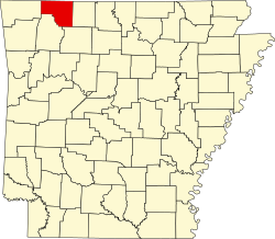
Carroll County, Arkansas
 Carroll County Courthouse |
|
| administration | |
|---|---|
| US state : | Arkansas |
| Administrative headquarters : | Berryville , Eureka Springs |
| Address of the administrative headquarters: |
Carroll County Courthouse 210 West Church Street Berryville, AR 72616 |
| Foundation : | November 1, 1833 |
| Made up from: | Izard County |
| Area code : | 001 870 |
| Demographics | |
| Residents : | 27,446 (2010) |
| Population density : | 16.8 inhabitants / km 2 |
| geography | |
| Total area : | 1655 km² |
| Water surface : | 22 km² |
| map | |
| Website : co.carroll.ar.us | |

The Carroll County is a county in the US -amerikanischen State Arkansas . In 2010 , the county had 27,446 residents and a population density of 16.8 people per square kilometer. With Berryville and Eureka Springs , the county has two county seats . The city of Berryville is named after its founder Blackburn Henderson Berry .
geography
The county is located in northwest Arkansas, borders Missouri to the north and has an area of 1,655 square kilometers, of which 22 square kilometers are water. The following neighboring counties border Carroll County:
|
Barry County, Missouri |
Stone County, Missouri |
Taney County, Missouri |
| Benton County |

|
Boone County |
| Madison County | Newton County |
history
Carroll County was formed on November 1, 1833 from parts of Izard County. It was named after Charles Carroll (1737-1832), a co-signer of the US Declaration of Independence and US Senator from Maryland .
The first white settlers in the area were William and Charles Sneed. The first post office was established in 1855, closed in 1856, and reopened in 1867. The first courthouse was built in 1880 and the first newspaper, the Carroll County Bowlder , was published. A few years later, Carrollton High School , Fairview Academy and Clarke's Academy were founded.
The boundaries of the county have changed several times in the past. So in 1836 and 1838 parts were given to form Madison and Searcy Counties. Another part was added to Newton County in 1842. The formation of Boone County in 1869 shrank Carroll County so much that it came under the required square miles, which in turn made it part of Madison County.
Demographic data
| Population development | |||
|---|---|---|---|
| Census | Residents | ± in% | |
| 1840 | 2844 | - | |
| 1850 | 4614 | 62.2% | |
| 1860 | 9383 | 103.4% | |
| 1870 | 5780 | -38.4% | |
| 1880 | 13,337 | 130.7% | |
| 1890 | 17,288 | 29.6% | |
| 1900 | 18,848 | 9% | |
| 1910 | 16,829 | -10.7% | |
| 1920 | 17,786 | 5.7% | |
| 1930 | 15,820 | -11.1% | |
| 1940 | 14,737 | -6.8% | |
| 1950 | 13,244 | -10.1% | |
| 1960 | 11,284 | -14.8% | |
| 1970 | 12.301 | 9% | |
| 1980 | 16,203 | 31.7% | |
| 1990 | 18,654 | 15.1% | |
| 2000 | 25,357 | 35.9% | |
| 2010 | 27,446 | 8.2% | |
| 1840-1890 1900-1990 2000-2010 | |||
As of the 2010 census , Carroll County had 27,446 people in 11,437 households. The population density was 16.8 inhabitants per square kilometer. Statistically speaking, 2.28 people lived in each of the 11,437 households.
The racial the population was composed of 95.4 percent white, 0.7 percent African American, 1.1 percent Native American, 0.7 percent Asian and other ethnic groups; 1.8 percent were descended from two or more races. Hispanic or Latino of any race was 13.3 percent of the population.
22.3 percent of the population were under 18 years old, 58.2 percent were between 18 and 64 and 19.5 percent were 65 years or older. 50.7 percent of the population was female.
The median income for a household was 34,235 USD . The per capita income was $ 19,743. 17.2 percent of the population lived below the poverty line.
Carroll County localities
1 - partially in Boone County
structure
Carroll County is divided into 21 townships :
Individual evidence
- ↑ Extract from the National Register of Historic Places - No. 76000392. Retrieved August 26, 2011
- ↑ GNIS-ID: 66975. Retrieved on February 22, 2011 (English).
- ↑ a b c U.S. Census Bureau, State & County QuickFacts - Carroll County, AR Retrieved July 22, 2012
- ^ Extract from the Encyclopedia of Arkansas.Retrieved February 12, 2011
- ^ US Census Bureau _ Census of Population and Housing.Retrieved February 17, 2011
- ^ Extract from Census.gov.Retrieved February 15, 2011
- ↑ Missouri Census Data Center - Arkansas ( page no longer available , search in web archives ) Info: The link was automatically marked as defective. Please check the link according to the instructions and then remove this notice. Retrieved July 22, 2012
Web links
Coordinates: 36 ° 22 ′ N , 93 ° 30 ′ W

