Benton County, Arkansas
![The Benton County Courthouse in Bentonville, listed on NRHP No. 87002340 [1]](https://upload.wikimedia.org/wikipedia/commons/thumb/9/9b/Benton_County_Courthouse%2C_Bentonville%2C_Arkansas.jpg/298px-Benton_County_Courthouse%2C_Bentonville%2C_Arkansas.jpg) The Benton County Courthouse in Bentonville, listed on NRHP No. 87002340 |
|
| administration | |
|---|---|
| US state : | Arkansas |
| Administrative headquarters : | Bentonville |
| Address of the administrative headquarters: |
Benton County Courthouse 215 East Central Bentonville, AR 72712 |
| Foundation : | September 30, 1836 |
| Made up from: | Washington County |
| Area code : | 001 479 |
| Demographics | |
| Residents : | 221,339 (2010) |
| Population density : | 101 inhabitants / km 2 |
| geography | |
| Total area : | 2280 km² |
| Water surface : | 89 km² |
| map | |
| Website : www.co.benton.ar.us | |
The Benton County is a county in Arkansas . The county seat is Bentonville . The county is part of the dry counties , which means that the sale of alcohol is restricted or prohibited.
Benton County is part of the Fayetteville – Springdale – Rogers metropolitan area in Arkansas and Missouri .
geography
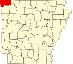
The county is located in the far northwest of Arkansas, borders Missouri to the north and Oklahoma to the west and has an area of 2,280 square kilometers, of which 89 square kilometers are water. It borders on the following counties:
|
McDonald County, Missouri |
Barry County, Missouri |
|
|
Delaware County (Oklahoma) |

|
Carroll County |
|
Adair County, Oklahoma |
Washington County | Madison County |
history
Benton County was formed on September 30, 1836 from parts of Washington County. It was named after Thomas Hart Benton , a US Senator from Missouri , after whom the city of Bentonville was named. During the Civil War , 1861 to 1865, the area was fiercely contested. From March 7th to 8th, 1862, the most strategically important battle west of the Mississippi , the Battle of Pea Ridge, took place here, which ended in favor of the northern states. Monuments and plaques for the fallen Confederate soldiers can still be found throughout the county.
Around 1880 the railways of the St. Louis & San Francisco Railroad and the Fort Smith, & Southern Railway , later renamed the Kansas City, Pittsburg and Gulf Railroad , and around 1900 renamed Kansas City Southern , brought a renewed upswing in this area.
After several well-known companies were founded here, the population doubled between 1950 and 1980. By 1990 it increased again by 25%.
economy
The main sources of income are the extraction of natural resources, agriculture, fruit growing, poultry and dairy products. In addition, well-known companies such as Little Debbie Bakeries , Cooper Communities , Bella Vista or Wal-Mart , the fastest growing retail chain in the United States, have their main headquarters here, which secures many jobs.
Demographic data
| growth of population | |||
|---|---|---|---|
| Census | Residents | ± in% | |
| 1840 | 2228 | - | |
| 1850 | 3710 | 66.5% | |
| 1860 | 9306 | 150.8% | |
| 1870 | 13,831 | 48.6% | |
| 1880 | 20,328 | 47% | |
| 1890 | 27,716 | 36.3% | |
| 1900 | 31,611 | 14.1% | |
| 1910 | 33,389 | 5.6% | |
| 1920 | 36,253 | 8.6% | |
| 1930 | 35,253 | -2.8% | |
| 1940 | 36,148 | 2.5% | |
| 1950 | 38,076 | 5.3% | |
| 1960 | 36,272 | -4.7% | |
| 1970 | 50,476 | 39.2% | |
| 1980 | 78.115 | 54.8% | |
| 1990 | 97,499 | 24.8% | |
| 2000 | 153,406 | 57.3% | |
| 2010 | 221,339 | 44.3% | |
| 1840-1890 1900-1990 2010 | |||
According to the 2000 census , Benton County had 153,406 people in 58,212 households and 43,484 families. The population density was 70 inhabitants per square kilometer. The racial the population was composed of 90.87 percent white, 0.41 percent African American, 1.65 percent Native American, 1.09 percent Asian, 0.08 percent of residents from the Pacific island area and 4.08 percent from other ethnic groups Groups. Hispanic or Latino of any race was 1.82 percent of the population.
Of the 58,212 households, 34.4 percent had children or adolescents under the age of 18 living with them. 63.0 percent were married couples living together, 8.2 percent were single mothers, and 25.3 percent were non-families. 21.1 percent of all households were single households and 8.5 percent had people aged 65 years or over. The average household size was 2.60 and the average family size was 3.01.
26.6 percent of the population were under 18 years old, 8.6 percent between 18 and 24, 29.4 percent between 25 and 44, 21.1 percent between 45 and 64 and 14.3 percent were 65 years or older. The median age was 35 years. Statistically, there were 97.4 males for every 100 females and an average of 94.9 males for every 100 females aged 18 and over.
The median income for a household in the 40,281 USD , and the median income for a family 45,235 USD. Males had a median income of $ 30,327 versus $ 22,469 for females. The per capita income was $ 19,377. 7.3 percent of families and 10.1 percent of the population lived below the poverty line.
Places in Benton County
Census-designated places (CDP)
1 - partially in Washington County
- other places
- Beacon addition
- Beaty
- Beaver Shores
- Bloomfield
- Brightwater
- Caverna
- Clantonville
- Clear Point
- Creech
- Cross Hollow
- Elkhorn Tavern
- Frisco
- Gallatin
- Glade
- Healing Springs
- Hickory Creek
- Ionia
- Lake Frances
- Larue
- Logan
- Mason Valley
- Monte Ne Shores
- Monte Ne
- Nebo
- Osage Mills
- Pedro
- Pine top
- Pleasure Heights
- Rago
- Robinson
- Seba
- Vaughn
- Was an eagle
- West Point
- Anderson Township
- Apple Glen Township
- Ball Township
- Beatie Township
- Brightwater Township
- Cherokee Township
- Colville Township
- Decatur Township
- Dickson Township
- Esculapia Township
- Felker Township
- Flint Township
- Garfield Township
- Garland Township
- Gentry Township
- Hico Township
- Hoover Township
- Logan Township
- Mason Valley Township
- Mount Vernon Township
- Osage Township
- Roller Ridge Township
- Round Prairie Township
- Sugar Creek Township
- Sulfur Springs Township
- Wager Township
- Wallace Township
- Walnut Township
- War Eagle Township
- Washington Township
- Yell Township
See also
Individual evidence
- ^ Extract from the National Register of Historic Places . Retrieved March 13, 2011
- ↑ GNIS-ID: 69896. Retrieved on February 22, 2011 (English).
- ^ Extract from the National Register of Historic Places . Retrieved March 13, 2011
- ^ Extract from the Encyclopedia of Arkansas . Retrieved February 12, 2011
- ^ US Census Bureau _ Census of Population and Housing.Retrieved February 17, 2011
- ^ Extract from Census.gov.Retrieved February 15, 2011
- ↑ United States Census 2010.Retrieved August 25, 2011
- ^ Benton County, Arkansas data sheet with the results of the 2000 census at factfinder.census.gov
Web links
- Official website
- US Census Bureau, State & County QuickFacts - Benton County
- Yahoo Image Search - Benton County
- www.city-data.com - Benton County
- Association of Arkansas Counties
Coordinates: 36 ° 21 ′ N , 94 ° 14 ′ W


