
Caddo Parish
 Caddo Parish Courthouse |
|
| administration | |
|---|---|
| US state : | Louisiana |
| Administrative headquarters : | Shreveport |
| Address of the administrative headquarters: |
Parish Courthouse P.O. Box 1127 Shreveport, LA 71163-1127 |
| Foundation : | 1838 |
| Made up from: | Natchitoches Parish |
| Area code : | 001 318 |
| Demographics | |
| Residents : | 254,969 (2010) |
| Population density : | 111.6 inhabitants / km 2 |
| geography | |
| Total area : | 2427 km² |
| Water surface : | 142 km² |
| map | |
 |
|
| Website : www.caddo.org | |
The Caddo Parish ( French. : Paroisse de Caddo ) is a Parish in US -amerikanischen State Louisiana . In 2010 , the parish had 254,969 residents and a population density of 111.6 people per square kilometer. The administrative seat ( Parish Seat ) is Shreveport , named after the discoverer Henry Miller Shreve .
The Caddo Parish is part of the metropolitan area Shreveport - Bossier City on the Red River .
geography
The Parish is located in the extreme northwest of Louisiana, borders Arkansas to the north, Texas to the west and is bounded by the Red River to the east. It has an area of 2427 square kilometers, of which 142 square kilometers are water. The following neighboring parishes and counties border the Caddo Parish:
| Cass County, Texas | Miller County, Arkansas | Lafayette County, Arkansas |
| Marion County, Texas , Harrison County, Texas |
.svg)
|
Bossier Parish |
| Panola County, Texas | De Soto Parish | Red River Parish |
history
The Caddo Parish was formed in 1838 from parts of the Natchitoches Parish . It was named after the Native American people of Caddo .
| Population development | |||
|---|---|---|---|
| Census | Residents | ± in% | |
| 1840 | 5282 | - | |
| 1850 | 8884 | 68.2% | |
| 1860 | 12,140 | 36.7% | |
| 1870 | 21,714 | 78.9% | |
| 1880 | 26,296 | 21.1% | |
| 1890 | 31,555 | 20% | |
| 1900 | 44,499 | 41% | |
| 1910 | 58,200 | 30.8% | |
| 1920 | 83,265 | 43.1% | |
| 1930 | 124,670 | 49.7% | |
| 1940 | 150.203 | 20.5% | |
| 1950 | 176,547 | 17.5% | |
| 1960 | 223,859 | 26.8% | |
| 1970 | 230.184 | 2.8% | |
| 1980 | 252.358 | 9.6% | |
| 1990 | 248.253 | -1.6% | |
| 2000 | 252.161 | 1.6% | |
| 2010 | 254,969 | 1.1% | |
| 2012 estimate | 257.093 | 0.8% | |
| 1830–1890 1900–1990 2000 2010–2012 | |||
Historical objects
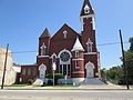
Antioch Baptist Church in Shreveport, listed on the NRHP since 1982

Kansas City Southern Railroad Bridge in Shreveport, listed on the NRHP since 1995

Shreveport Waterworks Pumping Station , listed on the NRHP since 1980

Strand Theater in Shreveport, listed on the NRHP since 1977


.jpg)

The Shreveport Municipal Memorial Auditorium and the Shreveport Waterworks Pumping Station have the status of a National Historic Landmark because of their special historical significance .
Other historical objects:
population
According to the 2010 census , the Caddo Parish had 254,969 people in 98,270 households. The population density was 111.6 inhabitants per square kilometer. Statistically, 2.52 people lived in each of the 98,270 households.
The racial the population was composed of 49.1 percent white, 47.7 percent African American, 0.5 percent Native American, 1.2 percent Asian, 0.1 percent Polynesian and other ethnic groups; 1.4 percent were descended from two or more races. Hispanic or Latino of any race was 2.6 percent of the population regardless of ethnicity.
24.5 percent of the population were under 18 years old, 61.6 percent were between 18 and 64 and 13.9 percent were 65 years or older. 52.5 percent of the population was female.
The median income for a household was 39,086 USD . The per capita income was $ 23,743. 20.1 percent of the population lived below the poverty line.
Locations in the Caddo Parish

Other Unincorporated Communities
1 - to a small extent in Bossier Parish
structure

The Caddo Parish is divided into twelve numbered districts:
|
|
Individual evidence
- ^ Caddo Parish in the Geographic Names Information System of the United States Geological Survey.Retrieved March 7, 2011.
- ↑ a b c U.S. Census Bureau, State & County QuickFacts - Caddo Parish, LA. Retrieved August 26, 2013.
- ^ A b National Association of Counties.Retrieved August 26, 2013.
- ^ US Census Bureau _ Census of Population and Housing.Retrieved February 17, 2011.
- ↑ Extract from Census.gov.Retrieved February 17, 2011.
- ↑ Extract from the National Register of Historic Places - No. 82000431.Retrieved August 26, 2013.
- ↑ Extract from the National Register of Historic Places - No. 95000347. Retrieved August 26, 2013.
- ↑ Extract from the National Register of Historic Places - No. 80001707. Retrieved August 26, 2013.
- ↑ Extract from the National Register of Historic Places - No. 77000668.Retrieved August 26, 2013.
- ↑ Listing of National Historic Landmarks by State: Louisiana . National Park Service , accessed October 23, 2017.
- ↑ Missouri Census Data Center - Louisiana ( page no longer available , search in web archives ) Info: The link was automatically marked as defective. Please check the link according to the instructions and then remove this notice. Retrieved August 26, 2013.
Web links
List of Parishes in Louisiana
Acadia |
Allen |
Ascension |
Assumption |
Avoyelles |
Beauregard |
Bienville |
Bossier |
Caddo |
Calcasieu |
Caldwell |
Cameron |
Catahoula |
Claiborne |
Concordia |
De Soto |
East Baton Rouge |
East Carroll |
East Feliciana |
Evangeline |
Franklin |
Grant |
Iberia |
Iberville |
Jackson |
Jefferson |
Jefferson Davis |
La Salle |
Lafayette |
Lafourche |
Lincoln |
Livingston |
Madison |
Morehouse |
Natchitoches |
Orleans |
Ouachita |
Plaquemines |
Pointe Coupee |
Rapides |
Red River |
Richland |
Sabine |
St. Bernard |
St. Charles |
St. Helena |
St. James |
St. John the Baptist |
St. Landry |
St. Martin |
St. Mary |
St. Tammany |
Tangipahoa |
Tensas |
Terrebonne |
Union |
Vermilion |
Vernon |
Washington |
Webster |
West Baton Rouge |
West Carroll |
West Feliciana |
Winn
Coordinates: 32 ° 35 ′ N , 93 ° 53 ′ W