San Luis Valley
| San Luis Valley | ||
|---|---|---|
|
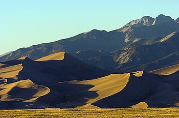
The San Luis Valley , mostly in the US state of Colorado |
||
| location | Colorado , New Mexico (USA) | |
| Mountains | San Juan Mountains , Sangre de Cristo Range | |
| Geographical location | 37 ° 28 ′ N , 105 ° 52 ′ W | |
|
|
||
| length | 180 km | |
The San Luis Valley is a wide valley of the southern Rocky Mountains , which extends in north-south direction for a length of around 180 km between the San Juan Mountains in the west and the Sangre de Cristo Range in the south. It extends from southern Colorado to northern New Mexico . It reaches a width of up to 90 km and, with a total area of over 21,000 square kilometers, is the world's largest alpine valley basin. Geologically, it is a rift fracture , which represents the easternmost trench in the Basin and Range region. The valley is at an average altitude of around 2300 meters, while the mountains surrounding the valley reach a height of over 4000 meters.
In the eastern part of the San Luis Valley, large sand dunes ( Great Sand Dunes ) formed in front of the mountains of the Sangre de Cristo Range , which were declared a Great Sand Dunes National Park in 2004 and are among the greatest attractions of Colorado. On the west side, the Rio Grande flows from the San Juan Mountains into the San Luis Valley and this is the only body of water that leaves the valley with the river running south to New Mexico.
Until their final expulsion in the mid-1890s, the San Luis Valley was the home of the Ute Indians, who from around 1850 were faced with an increasing number of Hispanic settlers, who mainly settled in the catchment area of the Rio Grande and from there livestock and agriculture lived. At the foot of the Sangre de Cristo Range, San Luis, the first permanent and now oldest settlement in today's Colorado , was built in the summer of 1851 . The valley has remained very sparsely populated to this day; The small towns of Alamosa , Monte Vista and Center in the center of the valley , which are strongly influenced by Mexico, are among the few noteworthy places . Potatoes , garden lettuce and barley in particular are among the most important agricultural products there.

Today the valley is opened up in north-south direction by US Highway 285 and in east-west direction by US 160 in the north and US 64 in the south. The economy is characterized by agriculture , which is mainly operated in the form of irrigation agriculture with large circular irrigation systems with a diameter of 400 m. In addition, tourism is a source of income, mainly in the vicinity of the national park.
Web links
- SLV Dweller - news portal for the region, which has existed since 2002
- sanluisvalley.us San Luis Valley Information Center
- Flickr photos

