Jacksonville, Arkansas
|
|
This article was on the basis of substantive defects quality assurance side of the project USA entered. Help bring the quality of this article to an acceptable level and take part in the discussion ! A closer description on the resolving issues is missing. |
| Jacksonville | |
|---|---|
|
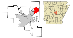
Location in county and Arkansas
|
|
| Basic data | |
| Foundation : | 1870 |
| State : | United States |
| State : | Arkansas |
| County : | Pulaski County |
| Coordinates : | 34 ° 52 ′ N , 92 ° 7 ′ W |
| Time zone : | Central ( UTC − 6 / −5 ) |
|
Inhabitants : - Metropolitan Area : |
28,364 (as of 2010) 610,518 (as of 2006) |
| Population density : | 415.3 inhabitants per km 2 |
| Area : | 68.8 km 2 (approx. 27 mi 2 ) of which 68.3 km 2 (approx. 26 mi 2 ) are land |
| Height : | 87 m |
| Postcodes : | 72076, 72078, 72099 |
| Area code : | +1 501 |
| FIPS : | 05-34750 |
| GNIS ID : | 0057978 |
| Website : | www.cityofjacksonville.net |
| Mayor : | Tommy Swaim |
Jacksonville is a city in Pulaski County in the US -amerikanischen State Arkansas with 28,364 inhabitants ( 2010 ). The urban area has a size of 68.8 km².
Population development
| Population development | |||
|---|---|---|---|
| Census | Residents | ± in% | |
| 1950 | 2474 | - | |
| 1960 | 14,488 | 485.6% | |
| 1970 | 19,832 | 36.9% | |
| 1980 | 27,589 | 39.1% | |
| 1990 | 29.101 | 5.5% | |
| 2000 | 29,916 | 2.8% | |
| 2010 | 28,364 | -5.2% | |
| 1950-2010 | |||
sons and daughters of the town
- Homer Martin Adkins (1890–1964), Governor of Arkansas from 1941 to 1945
- Kris Allen (* 1985), singer-songwriter
- Rocky Gray (* 1974), drummer for the heavy metal band Machina
Individual evidence
- ^ Extract from the Encyclopedia of Arkansas . Retrieved February 13, 2011

