Medford, Minnesota
| Medford | |
|---|---|
 |
|
| Location in Minnesota | |
| Basic data | |
| State : | United States |
| State : | Minnesota |
| County : | Steele County |
| Coordinates : | 44 ° 10 ′ N , 93 ° 15 ′ W |
| Time zone : | Central ( UTC − 6 / −5 ) |
| Residents : | 1,239 (as of 2010) |
| Population density : | 415.8 inhabitants per km 2 |
| Area : | 2.98 km 2 (approx. 1 mi 2 ) |
| Height : | 336 m |
| Postal code : | 55049 |
| Area code : | +1 507 |
| FIPS : | 27-41426 |
| GNIS ID : | 647731 |
| Website : | www.medfordminnesota.com |
| Mayor : | Marie Sexton |
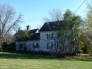
 The Daniel Piper House in Medford, listed on the NRHP since 1975 |
|
Medford is a small town (with the status " City ") in Steele County in the US -amerikanischen State Minnesota . In 2010 , Medford had 1239 residents.
geography
Medford is located in southern Minnesota on both sides of the Straight River , a tributary of the Cannon River, which flows into the Mississippi . The geographical coordinates of Medford are 44 ° 10'22 "north latitude and 93 ° 14'49" west longitude. The place extends over an area of 2.98 km².
Neighboring towns to Medford are Faribault (14.4 km north), Owatonna (11.2 km south) and Morristown (20.2 km west-northwest).
The nearest major cities are Minneapolis (95.6 km north), Minnesota's capital Saint Paul (102 km in the same direction), Rochester (80.3 km east), Cedar Rapids , Iowa (324 km south-southeast), Iowa's capital Des Moines (299 km south), Omaha , Nebraska (521 km southwest), Sioux Falls , South Dakota (340 km west southwest), and Fargo , North Dakota (471 km northwest).
traffic
Interstate 35 runs along the western outskirts of Medford and is the shortest connection from the Twin Cities to Des Moines. All other roads are subordinate country roads, some unpaved roads and inner-city connecting roads.
A Union Pacific Railroad line runs north-south through central Medford. A section of the smaller I&M Rail Link runs parallel to this .
The Owatonna Degner Regional Airport is 7.3 km south of a small airfield. The nearest major airport is Minneapolis-Saint Paul International Airport (56 miles north).
Demographic data
According to the 2010 census , Medford had 1,239 people in 450 households. The population density was 415.8 people per square kilometer. Statistically, there were 2.74 people in each of the 450 households.
The racial the population was composed of 96.3 percent white, 0.9 percent African American, 0.1 percent (one person) Native American, 0.6 percent Asian and 0.8 percent from other ethnic groups; 1.4 percent were descended from two or more races. Hispanic or Latino of any race was 5.2 percent of the population.
31.2 percent of the population were under 18 years old, 58.5 percent were between 18 and 64 and 10.3 percent were 65 years or older. 49.1 percent of the population was female.
The average annual income for a household was 64,265 USD . The per capita income was $ 23,817. 8.0 percent of the population lived below the poverty line.
Known residents
- Earl Douglass (1862–1931) - fossil collector and vertebrate paleontologist - born in Medford
- Lynn Frazier (1874–1947) - the twelfth Governor of North Dakota - born in Medford
Individual evidence
- ↑ Extract from the National Register of Historic Places - No. 75001028. Retrieved June 23, 2013
- ↑ a b American Fact Finder. Retrieved June 23, 2013
- ↑ Distance information according to Google Maps. Accessed June 23, 2013
