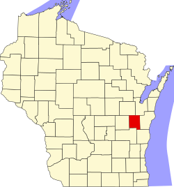
Calumet County
![The Calumet County Courthouse in Chilton, listed on the NRHP [1]](https://upload.wikimedia.org/wikipedia/commons/thumb/1/1e/CalumetCountyWisconsinCourthouse.jpg/298px-CalumetCountyWisconsinCourthouse.jpg) The Calumet County Courthouse in Chilton, listed on the NRHP |
|
| administration | |
|---|---|
| US state : | Wisconsin |
| Administrative headquarters : | Chilton |
| Address of the administrative headquarters: |
County Courthouse 206 Court Street Chilton, WI 53014-0000 |
| Foundation : | 1836 |
| Made up from: | Wisconsin Territory |
| Area code : | 001 920 |
| Demographics | |
| Residents : | 48,971 (2010) |
| Population density : | 59.1 inhabitants / km 2 |
| geography | |
| Total area : | 1028 km² |
| Water surface : | 200 km² |
| map | |
| Website : www.co.calumet.wi.us | |
The Calumet County is a county in the US -amerikanischen State Wisconsin . In 2010 , the county had 48,971 residents and a population density of 59.1 people per square kilometer. The county seat is Chilton .
geography
The county is located in eastern Wisconsin on the northeastern shore of Lake Winnebago and about 25 miles from Lake Michigan . It has an area of 1028 square kilometers, of which 200 square kilometers are water. The following neighboring counties border Calumet County:
| Outagamie County | Brown County | |
| Winnebago County |

|
Manitowoc County |
| Fond du Lac County | Sheboygan County |
history
Calumet County was formed in 1836 from parts of the Wisconsin Territory. It was named after the French word for the Indian peace pipe. Native Americans from New York State were relocated to the southwestern part from 1830. Many of the early residents of the Holyland region in the southern part were emigrants from Schleswig-Holstein in the 1840s.
Demographic data
| Population development | |||
|---|---|---|---|
| Census | Residents | ± in% | |
| 1900 | 17,078 | - | |
| 1910 | 16,701 | -2.2% | |
| 1920 | 17,228 | 3.2% | |
| 1930 | 16,848 | -2.2% | |
| 1940 | 17,618 | 4.6% | |
| 1950 | 18,840 | 6.9% | |
| 1960 | 22,268 | 18.2% | |
| 1970 | 27,604 | 24% | |
| 1980 | 30,867 | 11.8% | |
| 1990 | 34,291 | 11.1% | |
| 2000 | 40,631 | 18.5% | |
| 2010 | 48,971 | 20.5% | |
| 2012 estimate | 49,634 | 1.4% | |
| 1900–1990 2000 2010–2012 | |||
According to the 2010 census , there were 48,971 people in 18,248 households in Calumet County. The population density was 59.1 inhabitants per square kilometer. Statistically, 2.64 people lived in each of the 18,248 households.
The racial the population was composed of 95.6 percent white, 0.5 percent African American, 0.5 percent Native American, 2.2 percent Asian, 0.1 percent Polynesian and other ethnic groups; 1.2 percent were descended from two or more races. Regardless of ethnicity, 3.8 percent of the population was Hispanic or Latino of any race.
26.0 percent of the population were under 18 years old, 61.5 percent were between 18 and 64 and 12.5 percent were 65 years or older. 49.9 percent of the population was female.
The median income for a household was 63,395 USD . The per capita income was $ 28,182. 5.9 percent of the population lived below the poverty line.
Localities in Calumet County
Other Unincorporated Communities
1 - partly in Outagamie and in Winnebago County
2 - partly in Manitowoc County
3 - partly in Winnebago County
4 - partly in Fond du Lac County
5 - partly in Sheboygan County
structure
In addition to the six cities and five villages, Calumet County is divided into nine towns :
| Township | Population (2010) |
FIPS |
|---|---|---|
| Town of Brillion | 1486 | 55-09750 |
| Town of Brothertown | 1329 | 55-10350 |
| Town of Charlestown | 775 | 55-14000 |
| Town of Chilton | 1143 | 55-14500 |
| Town of Harrison | 10,839 | 55-32800 |
| Town of New Holstein | 1508 | 55-56825 |
| Town of Rantoul | 798 | 55-66275 |
| Town of Stockbridge | 1456 | 55-77425 |
| Town of Woodville | 980 | 55-89000 |
See also
Individual evidence
- ↑ Extract from the National Register of Historic Places - No. 82000640.Retrieved March 16, 2011
- ↑ Calumet County ( English ) In: Geographic Names Information System . United States Geological Survey . Retrieved February 22, 2011.
- ↑ a b c U.S. Census Bureau, State & County QuickFacts - Calumet County, WI. Retrieved September 5, 2013
- ^ A b National Association of Counties.Retrieved September 5, 2013
- ^ Extract from Census.gov.Retrieved February 28, 2011
- ↑ Missouri Census Data Center - Wisconsin ( page no longer available , search in web archives ) Info: The link was automatically marked as defective. Please check the link according to the instructions and then remove this notice. Retrieved September 5, 2013
Web links
Coordinates: 44 ° 5 ′ N , 88 ° 13 ′ W

