Kloten, Wisconsin
| Balls | ||
|---|---|---|
 |
||
| Location in Wisconsin | ||
|
|
||
| Basic data | ||
| State : | United States | |
| State : | Wisconsin | |
| County : | Calumet County | |
| Coordinates : | 44 ° 2 ′ N , 88 ° 16 ′ W | |
| Time zone : | Central ( UTC − 6 / −5 ) | |
| Height : | 313 m | |
| Postal code : | 53014 | |
| Area code : | +1 920 | |
| FIPS : | 55-39960 | |
| GNIS ID : | 1577680 | |
 |
||
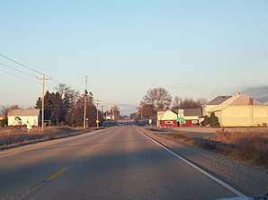
Kloten is a settlement on community-free area in Calumet County in the US -amerikanischen State Wisconsin .
The place is named after the Swiss town of Kloten .
geography
Kloten is located in eastern Wisconsin, 6 km east of Lake Winnebago and around 50 km west of Green Bay on Lake Michigan .
The geographic coordinates of Kloten are 44 ° 02'05 "north latitude and 88 ° 15'57" west longitude. The place is in the south of the Town of Stockbridge .
Neighboring towns of Kloten are Stockbridge (6.7 km northwest) and Chilton (8.8 km east).
The closest major cities are Appleton (38.4 km northwest), Green Bay on Lake Michigan (66 km northeast), Wisconsin's largest city, Milwaukee (131 km southeast), and Wisconsin's capital city, Madison (158 km southwest).
traffic
County highways F and C meet in Kloten. All other roads are subordinate country roads, some unpaved roads and inner-city connecting roads.
The nearest airport is Outagamie County Regional Airport at Appleton, 30 miles northwest .
Individual evidence
- ↑ Distance information according to Google Maps. Accessed September 15, 2014

