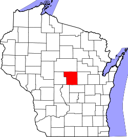
Portage County, Wisconsin
 Portage County Courthouse |
|
| administration | |
|---|---|
| US state : | Wisconsin |
| Administrative headquarters : | Stevens Point |
| Address of the administrative headquarters: |
County Courthouse 1516 Church Street Stevens Point, WI 54481-3501 |
| Foundation : | December 7, 1836 |
| Made up from: |
Brown County Crawford County Iowa County Milwaukee County |
| Area code : | 001 715 |
| Demographics | |
| Residents : | 70,019 (2010) |
| Population density : | 33.5 inhabitants / km 2 |
| geography | |
| Total area : | 2131 km² |
| Water surface : | 43 km² |
| map | |
| Website : www.co.portage.wi.us | |
The Portage County is a county in the US -amerikanischen State Wisconsin . In 2010 , the county had 70,019 residents and a population density of 33.5 people per square kilometer. By 2012 the population had increased to 70,433. The county seat is Stevens Point , named after George Stevens , an early settler in the area.
geography
The county is located slightly east of the geographic center of Wisconsin and has an area of 2,131 square kilometers, of which 43 square kilometers are water.
The county is traversed by the Wisconsin River , a left tributary of the Mississippi . The county's largest tributary to the Wisconsin River is the Plover River .
The following neighboring counties border Portage County:
| Marathon County | Shawano County | |
| Wood County |

|
Waupaca County |
| Adams County | Waushara County |
history
Portage County was formed on December 7, 1836 from parts of Brown County, Crawford County, Iowa County, and Milwaukee County. It was named after the watershed ( French : Portage - transition) between the Fox River and the Wisconsin River.
| Population development | |||
|---|---|---|---|
| Census | Residents | ± in% | |
| 1900 | 29,483 | - | |
| 1910 | 30,945 | 5% | |
| 1920 | 33,649 | 8.7% | |
| 1930 | 33,827 | 0.5% | |
| 1940 | 35,800 | 5.8% | |
| 1950 | 34,858 | -2.6% | |
| 1960 | 36,964 | 6% | |
| 1970 | 47,541 | 28.6% | |
| 1980 | 57,420 | 20.8% | |
| 1990 | 61,405 | 6.9% | |
| 2000 | 67,182 | 9.4% | |
| 2010 | 70.019 | 4.2% | |
| 2012 estimate | 70,433 | 0.6% | |
| 1900–1990 2000 2010–2012 | |||
population
According to the 2010 census , Portage County had 70,433 people in 27,982 households. The population density was 33.5 inhabitants per square kilometer. Statistically, there were 2.38 people each in the 27,982 households.
The racial the population was composed of 94.9 percent white, 0.7 percent African American, 0.4 percent Native American, 2.8 percent Asian and other ethnic groups; 1.2 percent were descended from two or more races. Hispanic or Latino of any race was 2.9 percent of the population.
20.1 percent of the population were under 18 years old, 66.2 percent were between 18 and 64 and 13.7 percent were 65 years or older. 49.9 percent of the population was female.
The median income for a household was 51,422 USD . The per capita income was $ 25,208. 13.5 percent of the population lived below the poverty line.
Portage County localities
Census-designated places (CDP)
Other Unincorporated Communities
1 - partially in Wood County
structure
In addition to the City of Stevens Point and the ten Villages, Portage County is divided into 17 towns :
|
|
See also
Individual evidence
- ↑ Portage County in the United States Geological Survey's Geographic Names Information System.Retrieved February 22, 2011
- ↑ a b c U.S. Census Bureau, State & County QuickFacts - Portage County, WI. Retrieved March 22, 2014
- ^ A b National Association of Counties.Retrieved March 22, 2014
- ^ Extract from Census.gov.Retrieved February 28, 2011
- ↑ Missouri Census Data Center - Wisconsin ( Memento of the original from January 18, 2016 in the Internet Archive ) Info: The archive link was inserted automatically and has not yet been checked. Please check the original and archive link according to the instructions and then remove this notice. Retrieved March 22, 2014
Web links
Coordinates: 44 ° 29 ′ N , 89 ° 30 ′ W
