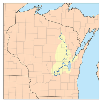
Fox River (Lake Michigan)
| Fox River | ||
|
Course of the Fox River |
||
| Data | ||
| Water code | US : 1565232 | |
| location | Wisconsin (USA) | |
| River system | Saint Lawrence River | |
| Drain over | St. Clair River → Detroit River → Niagara River → Saint Lawrence River → Atlantic Ocean | |
| source |
Columbia County near Pardeeville 43 ° 38 ′ 35 " N , 89 ° 3 ′ 48" W |
|
| muzzle |
Green Bay (Lake Michigan) coordinates: 44 ° 32 ′ 24 " N , 88 ° 0 ′ 16" W 44 ° 32 ′ 24 " N , 88 ° 0 ′ 16" W |
|
| Mouth height |
177 m
|
|
| length | 322 km | |
| Left tributaries | Wolf River | |
| Flowing lakes | Lake Winnebago | |
The Fox River is a river in central and eastern Wisconsin in the United States .
It flows south to north through numerous cities such as Neenah, Menasha, Appleton , Little Chute, Kimberly Combined Locks, and Kaukauna. Geographically, the river is divided into an upper part, which extends from central Wisconsin to Lake Winnebago , and a lower part, which connects Lake Winnebago with Green Bay ( Lake Michigan) . Together, the two parts have a length of 322 kilometers (200 miles).
history
After the glaciers that once covered large parts of the state of Wisconsin receded, the Fox River became an important natural resource for numerous Indian tribes. Archaeologists assume that the first humans lived in the greater region of the Fox River as early as 7000 BC.
Before European colonization in the late 17th century, the banks of the Fox River were estimated to be home to around half of the 25,000 or so Indians who inhabited what is now the state of Wisconsin.
The first Europeans
The first Europeans reached the Fox River in 1634 when the French explored the area under the guidance of Jean Nicolet . In 1673 Jacques Marquette and Louis Joliet reached Portage using canoes. The city of Portage owes its name to the English word of the same name (English for "to carry water vehicles" to be able to avoid obstacles in the water section). They got from the Fox River to the Wisconsin River by land and continued their journey by water, eventually paddling towards the Mississippi River . This enabled them to establish an important waterway between the Great Lakes and the Mississippi. The waterway became known as the Fox – Wisconsin Waterway and was a frequently used route for fur traders during the French colonization of the American continent.
Industrial revolution
Even in the 1850s, the Fox – Wisconsin Waterway did not lose its importance. The Fox and Wisconsin Improvement Company built dams to connect the Fox River and the Wisconsin River at Portage. The company hoped to establish Green Bay as a port city and as a competitor to Chicago . The ambitious goal could never be achieved, which was certainly largely due to the shallow depth of the upper part of the Fox River. Larger ships could not use the passage. Instead of the planned development as a cargo handling point, the area on the lower part of the Fox River became the industrial center of an entire region.
During the 19th century, when Wisconsin was the leading producer of wheat , numerous (flour) mills were built on the banks of the Fox River, powered by the power of flowing water. In the 1860s, Wisconsin's wheat production declined significantly and the (wheat) mills were quickly converted into paper mills . Numerous well-known paper producers , including Kimberly-Clark , Northern Paper Mills ( Quilted Northern ) and the Hoberg Paper Company ( Charmin ) settled in the area.
Today there are 24 paper mills along the Fox River, producing more than five million tons of paper annually and employing around 50,000 people.
environmental pollution
The high concentration of paper mills and other industrial facilities along the banks of the Lower Fox River resulted in relatively heavy pollution of the river. Numerous organizations such as Fox River Watch or the Fox River / Green Bay Clean Up Project have repeatedly addressed this problem.
Public debates on the matter began as early as 1923 , but little to nothing had been done until the Clean Water Act was passed in 1972. Since then, a lot has been done to clean up the Fox River again. Despite all efforts, the problem persists and the river is perceived as severely polluted by a majority of the population in the area in particular.
According to some measurements (oxygen, counts of certain worm species) the lower part of the Fox River, contrary to this subjective perception of the population, has become significantly cleaner at least compared to the years before 1972. Other measurements ( phosphorus and estrogen content) as well as traces of pharmaceutical agents confirm the perception of the local population and show an increase in pollution since 1972.
Web links
Individual evidence
- ^ Fox River in the Geographic Names Information System of the United States Geological Survey
- ↑ a b c d Clean Water Action Council. Green Bay, WI. "History of the Fox River and Green Bay." ( Memento of the original from October 11, 2008 in the Internet Archive ) Info: The archive link was inserted automatically and has not yet been checked. Please check the original and archive link according to the instructions and then remove this notice. Retrieved January 16, 2011.
- ^ A b c Gwen M. Schultz: Wisconsin's Foundations: A Review of the State's Geology and Its Influence on Geography and Human Activity. The University of Wisconsin Press, 2004, ISBN 0-299-19874-X , pp. 128-129.
