Columbia County, Wisconsin
 Columbia County Courthouse |
|
| administration | |
|---|---|
| US state : | Wisconsin |
| Administrative headquarters : | Portage |
| Address of the administrative headquarters: |
County Courthouse 400 DeWitt Street Portage, WI 53901-0177 |
| Foundation : | 1846 |
| Made up from: | Portage County |
| Area code : | 001 608 |
| Demographics | |
| Residents : | 56,833 (2010) |
| Population density : | 28.4 inhabitants / km 2 |
| geography | |
| Total area : | 2061 km² |
| Water surface : | 57 km² |
| map | |
| Website : www.co.columbia.wi.us | |
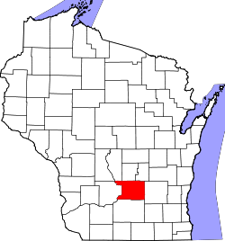
The Columbia County is a county in the US -amerikanischen State Wisconsin . In 2010 , the county had 56,833 residents and a population density of 28.4 people per square kilometer. The county seat is Portage .
Columbia County is part of the Madison metropolitan area .
geography
The county is located in south-central Wisconsin and has an area of 2061 square kilometers, of which 57 square kilometers are water.
In the west, the county is traversed by the Wisconsin River , a left tributary of the Mississippi . The Fox River, which flows into Lake Michigan, has its source in the north of the county .
The watershed between the two rivers was previously bridged by the Portage Canal near the city of Portage . Up until the first half of the 20th century , the Fox – Wisconsin Waterway formed a waterway from the Mississippi to the Great Lakes via a series of barriers and locks on both sides of the watershed .
The following neighboring counties border Columbia County:
| Adams County , Juneau County |
Marquette County |
Green Lake County |
| Sauk County |

|
Dodge County |
| Dane County |
history
Columbia County was formed in 1846 from parts of Portage County. It was named after Christopher Columbus .
population
| Population development | |||
|---|---|---|---|
| Census | Residents | ± in% | |
| 1900 | 31,121 | - | |
| 1910 | 31,129 | 0% | |
| 1920 | 30,468 | -2.1% | |
| 1930 | 30.503 | 0.1% | |
| 1940 | 32,517 | 6.6% | |
| 1950 | 34,023 | 4.6% | |
| 1960 | 36,708 | 7.9% | |
| 1970 | 40,150 | 9.4% | |
| 1980 | 43,222 | 7.7% | |
| 1990 | 45,088 | 4.3% | |
| 2000 | 52,468 | 16.4% | |
| 2010 | 56,833 | 8.3% | |
| 2012 estimate | 56,539 | -0.5% | |
| 1900–1990 2000 2010–2012 | |||
As of the 2010 census , Columbia County had 56,833 people in 22,888 households. The population density was 28.4 inhabitants per square kilometer. Statistically, 2.4 people lived in each of the 22,888 households.
The racial the population was composed of 96.3 percent white, 1.4 percent African American, 0.6 percent Native American, 0.6 percent Asian, 0.1 percent Polynesian and other ethnic groups; 1.0 percent were descended from two or more races. Hispanic or Latino of any race was 2.6 percent of the population regardless of ethnicity.
22.7 percent of the population were under 18 years old, 62.0 percent were between 18 and 64 and 15.3 percent were 65 years or older. 49.1 percent of the population was female.
The median income for a household was 57,805 USD . The per capita income was $ 28,160. 8.7 percent of the population lived below the poverty line.
Columbia County localities
Other Unincorporated Communities
1 - partly in Sauk County
2 - partly in Dodge County
3 - partly in Adams , Juneau and Sauk Counties
structure
Columbia County is divided into four cities and ten villages in 21 towns :
|
|
|
See also
Individual evidence
- ^ Columbia County in the United States Geological Survey's Geographic Names Information System.Retrieved February 22, 2011
- ↑ a b c U.S. Census Bureau, State & County QuickFacts - Columbia County, WI. Retrieved September 30, 2013
- ↑ a b National Association of Counties.Retrieved September 30, 2013
- ^ Extract from Census.gov.Retrieved February 28, 2011
- ↑ Missouri Census Data Center - Wisconsin ( page no longer available , search in web archives ) Info: The link was automatically marked as defective. Please check the link according to the instructions and then remove this notice. Retrieved September 30, 2013
Web links
Coordinates: 43 ° 28 ′ N , 89 ° 20 ′ W


