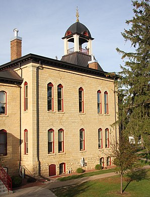
Vernon County, Wisconsin
 Vernon County Courthouse |
|
| administration | |
|---|---|
| US state : | Wisconsin |
| Administrative headquarters : | Viroqua |
| Address of the administrative headquarters: |
County Courthouse Courthouse Annex Viroqua, WI 54665-0000 |
| Foundation : | 1851 |
| Made up from: |
Crawford County Richland County |
| Area code : | 001 608 |
| Demographics | |
| Residents : | 29,773 (2010) |
| Population density : | 14.5 inhabitants / km 2 |
| geography | |
| Total area : | 2114 km² |
| Water surface : | 56 km² |
| map | |
| Website : www.vernoncounty.org | |
The Vernon County is a county in the US -amerikanischen State Wisconsin . In 2010 , the county had 29,773 people and a population density of 14.5 people per square kilometer. The county seat is Viroqua .
geography
The county is located in central southwest Wisconsin, in the Driftless Area known as the Ice Age-shaped region that stretches across southeastern Minnesota, southwestern Wisconsin, northeastern Iowa, and far northwestern Illinois. During the last ice age, the so-called Wisconsin Glaciation , the region remained ice-free, so that the river valleys could cut deeper into the plateau during this time.
Vernon County is bounded to the west by the Mississippi , which also forms the natural border between Wisconsin and Iowa and Minnesota . Vernom County covers an area of 2,114 square kilometers, of which 56 square kilometers are water.
The following neighboring counties border Vernon County:
| La Crosse County | Monroe County | Juneau County |
|
Houston County, Minnesota |

|
Sauk County |
|
Allamakee County, Iowa |
Crawford County | Richland County |
history
| Population development | |||
|---|---|---|---|
| Census | Residents | ± in% | |
| 1900 | 28,351 | - | |
| 1910 | 28,116 | -0.8% | |
| 1920 | 29,252 | 4% | |
| 1930 | 28,537 | -2.4% | |
| 1940 | 29,940 | 4.9% | |
| 1950 | 27,906 | -6.8% | |
| 1960 | 25,663 | -8th % | |
| 1970 | 24,557 | -4.3% | |
| 1980 | 25,642 | 4.4% | |
| 1990 | 25,617 | -0.1% | |
| 2000 | 28,056 | 9.5% | |
| 2010 | 29,773 | 6.1% | |
| 1900–1990 2000 2010–2012 | |||
Vernon County was formed in 1851 from parts of Crawford County and Richland Counties as Bad Ax County . It was later renamed after the Mount Vernon manor , home of George Washington .
population
According to the 2010 census , Vernon County had 29,773 people in 11,737 households. The population density was 14.5 inhabitants per square kilometer. Statistically, 2.51 people lived in each of the 11,737 households.
The racial the population was composed of 98.1 percent white, 0.4 percent African American, 0.2 percent Native American, 0.4 percent Asian and other ethnic groups; 0.9 percent were descended from two or more races. Regardless of ethnicity, 1.5 percent of the population was Hispanic or Latino of any race.
25.7 percent of the population were under 18 years old, 56.6 percent were between 18 and 64 and 17.7 percent were 65 years or older. 50.0 percent of the population was female.
The median income for a household was 44,676 USD . The per capita income was $ 22,183. 15.2 percent of the population lived below the poverty line.
Vernon County localities
1 - partly in Crawford County
2 - partly in Richland County
structure
Vernon County is divided into 21 towns in addition to the three cities and nine villages :
|
|
|
See also
Individual evidence
- ^ Vernon County in the United States Geological Survey's Geographic Names Information System.Retrieved February 22, 2011
- ↑ a b c U.S. Census Bureau, State & County QuickFacts - Vernon County, WI. Retrieved December 23, 2013
- ↑ a b National Association of Counties.Retrieved December 23, 2013
- ^ Extract from Census.gov.Retrieved February 28, 2011
- ↑ Missouri Census Data Center - Wisconsin ( Memento of the original from January 18, 2016 in the Internet Archive ) Info: The archive link was inserted automatically and has not yet been checked. Please check the original and archive link according to the instructions and then remove this notice. Retrieved December 23, 2013
Web links
Coordinates: 43 ° 35 ′ N , 90 ° 50 ′ W

