Meenon
| Meenon | ||
|---|---|---|
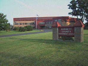
 The Burnett County Government Center |
||
| Location in Wisconsin | ||
|
|
||
| Basic data | ||
| State : | United States | |
| State : | Wisconsin | |
| County : | Burnett County | |
| Coordinates : | 45 ° 51 ′ N , 92 ° 20 ′ W | |
| Time zone : | Central ( UTC − 6 / −5 ) | |
| Residents : | 1,163 (as of 2010) | |
| Population density : | 14.1 inhabitants per km 2 | |
| Area : | 86.2 km 2 (approx. 33 mi 2 ) of which 82.6 km 2 (approx. 32 mi 2 ) are land |
|
| Height : | 300 m | |
| Area code : | +1 715,534 | |
| FIPS : | 55-50650 | |
| GNIS ID : | 1583687 | |
 Location of the Town of Meenon in Burnett County |
||
The Town of Meenon is one of 21 Towns in Burnett County in the US -amerikanischen State Wisconsin . In 2010 Meenon had 1163 inhabitants.
Town has a fundamentally different meaning in Wisconsin than in the rest of the English-speaking area. Rather, it corresponds to the usual townships in the other US states , which form the next smaller administrative unit after the county .
geography
The Town of Meenon is located in northwest Wisconsin and is traversed from southeast to northwest by the Clam River , a left tributary of the St. Croix River , which flows into the Mississippi and forms the border with Minnesota .
The geographical coordinates of the center of the Town of Meenon are 45 ° 50'36 "north latitude and 92 ° 20'10" west longitude. It extends over an area of 86.2 km², which is spread over 82.6 km² of land and 3.6 km² of water.
The Town of Meenon is located in the center of Burnett County and borders the following neighboring towns:
| Town of Union | Town of Oakland | Town of Jackson |
| Town of Lincoln |

|
Town of Sand Lake |
| Town of Daniels | Town of Siren | Town of La Follette |
In the south of the Town of Meenon is located on the border with the town of Siren the Burnett County Government Center . In the northwest lies the independent town of Webster, which is completely surrounded by the Town of Meenon .
traffic
The Wisconsin State Highway 35 runs north-south through the Town of Meenon. The Wisconsin State Highway 70 runs in a west-east direction through the town. All other roads are subordinate country roads, some unpaved roads and inner-city connecting roads.
Through the Town of Meenon runs in a north-south direction with the Gandy Dancer State Trail, a combined hiking and cycling path known as the Rail Trail on the route of a disused railway line. The name of the path goes back to the slang word Gandy Dancer , which was used to describe a railroad worker.
With the Burnett County Airport is located in the south of the Town of Meenon, opposite the Countyverwaltungsgebäude, a small airfield. The nearest major airport is Minneapolis-Saint Paul International Airport (170 km southwest).
population
According to the 2010 census , the Town of Meenon had 1,163 people in 487 households. The population density was 14.1 people per square kilometer. Statistically, 2.27 people lived in each of the 487 households.
The racial the population was composed of 91.2 percent white, 0.3 percent African American, 4.2 percent Native American, 0.4 percent Asian, 0.1 percent (one person) Polynesians and 0.3 percent from other ethnic groups Groups; 3.4 percent were descended from two or more races. Hispanic or Latino of any race was 0.4 percent of the population.
22.4 percent of the population were under 18 years old, 58.7 percent were between 18 and 64 and 18.9 percent were 65 years or older. 46.9 percent of the population was female.
The average annual income for a household was 46,016 USD . The per capita income was $ 22,222. 16.8 percent of the population lived below the poverty line.
Individual evidence
- ↑ a b American Fact Finder. Retrieved September 3, 2013
- ↑ Distance information according to Google Maps. Accessed on September 3, 2013
- ↑ Trails from Rails - Gandy Dancer State Trail ( Memento of the original from August 26, 2011 in the Internet Archive ) Info: The archive link was inserted automatically and has not yet been checked. Please check the original and archive link according to the instructions and then remove this notice. Retrieved September 3, 2013
- ↑ AirNav.com - Burnett County Airport Retrieved on September 3, 2013
