Ellsworth, Wisconsin
| Ellsworth | ||
|---|---|---|
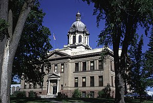
 Pierce County Courthouse in Ellsworth |
||
| Location in Wisconsin | ||
|
|
||
| Basic data | ||
| Foundation : | 1862 | |
| State : | United States | |
| State : | Wisconsin | |
| County : | Pierce County | |
| Coordinates : | 44 ° 44 ′ N , 92 ° 29 ′ W | |
| Time zone : | Central ( UTC − 6 / −5 ) | |
| Residents : | 2,909 (as of: 2000) | |
| Population density : | 306.2 inhabitants per km 2 | |
| Area : | 9.5 km 2 (approx. 4 mi 2 ) of which 9.5 km 2 (approx. 4 mi 2 ) is land |
|
| Height : | 370 m | |
| Postcodes : | 54011, 53010 | |
| Area code : | +1 715 | |
| FIPS : | 55-23550 | |
| GNIS ID : | 1564550 | |
| Website : | www.villageofellsworth.org | |
| Mayor : | Gerald DeWolfe (President) | |
Ellsworth is a village and the administrative center of the Pierce County in western US -amerikanischen state of Wisconsin . In 2000 Ellsworth had 2,909 residents.
geography
Ellsworth lies at 44 ° 43'57 "north latitude and 92 ° 28'48" west longitude and extends over 9.55 km², which consists exclusively of land.
Ellsworth is about 12 miles north of the Mississippi River , which forms the border between Wisconsin and Minnesota .
US Highways 10 and 63 and Wisconsin Highways 65 and 72 meet in Ellsworth .
The closest cities are the Red Wing , Minnesota 14 miles south , Hastings , Minnesota 22.6 km west, and River Falls 13.4 miles northwest .
The Twin Cities ( Minneapolis and Saint Paul ) in Minnesota are 63.1 km to the northwest, Eau Claire 88.9 km to the east and Rochester , Minnesota 105 km to the south.
history
In 1857 the first white settler families came to the area. The place Ellsworth was founded in 1862 and made an official parish in 1887. In 1885 the Omaha Railroad laid a depot east of the city, from which the place East Ellsworth was formed. The congregations existed independently of one another for a long time, but have now grown together into one. Only the different postcode 53010 for East Ellsworth is still valid today.
The place was named after Colonel Elmer E. Ellsworth , who died in the American Civil War .
Demographic data
In the 2000 census, the population was 2,909. These were distributed over 1,169 households in 755 families. The population density was 304.6 inhabitants per square kilometer. There were 1,218 residential buildings, which corresponded to a building density of 127.6 buildings per square kilometer.
The population in 2000 was 98.2 percent white , 0.2 percent Native American , 0.1 percent Asian, and 0.6 percent other. 0.9 percent said they came from at least two of these groups. 1.1 percent of the population was Hispanic from any of the above groups.
24.6 percent were under 18 years of age, 9.6 percent between 18 and 24, 28.5 percent from 25 to 44, 21.6 percent from 45 to 64 and 15.7 percent 65 and over. The mean age was 36 years. For every 100 women there were statistically 93.8 men, 85.9 among the over 18-year-olds.
The median income per household was 42,604 US dollars (USD), the median family income 51,286 USD. The median income for men was $ 36,069 and that for women was $ 25,000. The per capita income was $ 18,661. Around 2.6 percent of families and 5.4 percent of the total population had their income below the poverty line .
Individual evidence
- ↑ US Postal Service - ZIP Codes
- ↑ www.uszip.com
- ↑ Google Maps: Ellsworth, WI - Mississippi River
- ^ Google Maps: Ellsworth, WI - Red Wing, MN
- Jump up ↑ Google Maps: Ellsworth, WI - Hastings, MN
- ↑ Google Maps: Ellsworth, WI - River Falls, WI
- ^ Google Maps: Ellsworth, WI - Saint Paul, MN
- ^ Google Maps: Ellsworth, WI - Eau Claire, WI
- ^ Google Maps: Ellsworth, WI - Rochester, MN
- ^ History of Ellsworth
- ↑ US Census Bureau - Ellsworth, Wisconsin
