Ederseeweg
| Ederseeweg | |
|---|---|
 Edersee : Reservoir in Northern Hesse and namesake of the Ederseeweg (view from Waldeck Castle towards the dam) |
|
| Data | |
| length | approx. 49 km |
| location | North Hesse |
| Markers |

|
| Starting point |
Kassel - Bad Wilhelmshöhe 51 ° 18 ′ 56.2 ″ N , 9 ° 25 ′ 24.9 ″ E |
| Target point |
Nieder-Werbe / Edersee 51 ° 12 ′ 25.2 ″ N , 9 ° 0 ′ 21.3 ″ E |
| The highest point | in the Langenbergen ( Vogelrain refuge ; approx. 475 m above sea level ) |
| Lowest point |
Kassel ( Mulangstrasse junction from Wilhelmshöher Allee ; 231 m above sea level ) |
| Level of difficulty | easy, normal |
| season | all year round |
| Viewpoints | u. a. Bismarck Tower Kassel , Hessenturm |
| particularities | named after the Edersee |
The Ederseeweg is a 49 km long hiking trail in northern Hesse ( Germany ) that has existed since 1928 and runs from Kassel through the Habichtswälder Bergland and the Waldecker Wald to Nieder-Werbe am Edersee (after which it is named) in the Kellerwald-Edersee Nature Park . It connects the independent city of Kassel and numerous towns and communities in the districts and districts of Kassel , Schwalm-Eder and Waldeck-Frankenberg . His sign is a white "E" on a black background.
History and interesting facts
The Ederseeweg was opened in 1928. With the help of display boards that were set up by local history and history associations along the way, you can find out about interesting things in the respective regions.
course
The Ederseeweg begins in the Kassel district of Bad Wilhelmshöhe below the Wilhelmshöhe Castle at the KVG tram stop Wilhelmshöhe ; The Herkulesweg runs past her a little north .
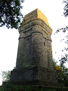
Initially, the path leads through the Habichtswald Nature Park along the eastern edge of the Hohen Habichtswald towards the south - at its lowest point at the junction of Mulangstrasse from Wilhelmshöher Allee ( 231 m above sea level ) and at the same time touching Bergpark Wilhelmshöhe . He crosses the Drusel and a little later a source stream of the Grunnelbach . Then he passes the Brasselsberg ( 434.2 m ); During a detour, from the Kassel Bismarck Tower on the mountain, you can enjoy the view over Kassel, including the Kaufungen Forest .
Then the path, which now faces south-west, runs past the seven ponds, which are a bit off the path, in the direction of the Hirzstein ( 502 m ), with a view of the rock face. Below it, after crossing under the federal autobahn 44 and reaching the district of Kassel through Elgershausen , where it crosses the Bauna after crossing the Baunapfads and Märchenlandweg , to cross the Kassel – Naumburg railway at the exit . Then it crosses the main ridge of the Langenberge - from the Kassel district in between to the Schwalm-Eder district - and reaches its highest point at the Vogelrain refuge (approx. 475 m ).
Shortly afterwards, the path, which now faces west, leads over the northern flank of the Niedensteiner Kopf ( 475 m ); During a detour, you can enjoy the view of the Habichtswälder Bergland and the Fritzlarer Börde from the Hessenturm standing on the mountain . In Niedenstein it crosses the Wiehoff and then runs in the Hinterhabichtswälder peaks along the southern edge of the forest of the Altenburg mountain ( 450.7 m ), on which the prehistoric Altenburg castle was once located. Afterwards it leads - again in the Kassel district - together with the Herkulesweg and Märchenlandweg down to and through Bad Emstal , where it crosses the Ems .
The path then crosses the Elberberger Heights along with the Märchenlandweg in a westward direction and then leads through the core town of Naumburg on the Elbe . Then it leads - walking alone again - up into the Waldecker Wald , on whose main ridge the Diemel-Eder-Weg and the student path cross and where it leaves the Habichtswald Nature Park and enters the Waldeck-Frankenberg district. Downhill it runs past the Netzer Tiergarten by Selbach , where he also write the Selbach -called Reiherbach crossed.
After subsequently passing under the Edersee web-cycle path (formerly Edersee web ) of the leads the way down along the southwest Heron Bach to the northern edge of natural parks Keller Edersee lying low advertising . Directly south of the village, the path ends at the Uferstraße bridge - after passing two fore basins (at the Reiherbach and at the Werbe ) - at the Edersee reservoir ( 244.97 m ) within the nature park .
Hessenturm on the Niedensteiner head
Altenburg mountain near Niedenstein
Web links
Individual evidence
- ↑ a b c d Ederseeweg , on myheimat.de
- ↑ a b Topographic map Stadtatlas Kassel ( M. = 1: 10.000), publisher : Stadt Kassel, Vermessung und Geoinformation, 2009


