Niedensteiner head
| Niedensteiner head | ||
|---|---|---|
|
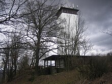
View from the Ederseeweg on the Altenburg mountain of the Niedensteiner Altenburg to Niedenstein with the Niedensteiner Kopf |
||
| height | 475 m above sea level NHN | |
| location | at Niedenstein ; Schwalm-Eder-Kreis , Hessen ( Germany ) | |
| Mountains | Hinterhabichtswälder peaks , Habichtswald | |
| Coordinates | 51 ° 14 ′ 7 " N , 9 ° 19 ′ 16" E | |
|
|
||
| rock | basalt | |
| particularities | Hessenturm ( AT ) with restaurant; former castle location | |
The Niedensteiner head in the Habichtswälder Bergland is 475 m above sea level. NHN high basalt dome east of the core town of Niedenstein in the north Hessian Schwalm-Eder district .
While there was a castle on the mountain in the Middle Ages, the Hessenturm and a hiking restaurant are popular excursion destinations there today .
geography
location
The Niedensteiner Kopf lies on the southern edge of the Habichtswälder Bergland and is the southeasternmost of the Hinterhabichtswälder peaks . In the Habichtswald Nature Park , it rises as the western foothills of the Langenberge between the Niedenstein core city directly to the west and the Niedenstein district of Ermetheis in the southeast. To the west past the mountain, which is particularly overgrown with spruce , the Ems tributary Wiehoff flows .
Natural allocation
The Niedensteiner Kopf belongs to the natural spatial main unit group West Hessian mountain and sink country (No. 34) and in the main unit Habichtswälder Bergland (342) to the natural area Hinterhabichtswälder Kuppen (342.2) and forms its south-southeastern end. The landscape leads east into the natural area Langenberg (342.02). To the south and west it falls into the natural area Fritzlarer Börde (343.23), which belongs to the subunit Hessengau (343.2) in the main unit West Hessian Basin (343) .
Castle history
In the Middle Ages , Niedenstein Castle , built between 1160 and 1164, stood on the mountain . The first documentary mention is from the year 1254, when Konrad von Elben held the castle for the Duchess Sophie von Brabant and her son Heinrich I against the people of the Archbishop of Mainz Gerhard I von Dhaun . Konrad von Elben then founded the new settlement "Nydensteyne", which was already designated as a town in 1259, on the western slope of the Burgberg on the western slope of the Burgberg, in the original Wichdorf area that belonged to him . The complex was then obviously in the possession of Landgrave Heinrich I of Hesse and his successors and was occupied by castle men and ministers from the surrounding local nobility. The castle was heavily devastated in 1387 by the troops of the Archbishop of Mainz Adolf I of Nassau , after which it was only partially restored and finally completely destroyed in the Thirty Years War . As early as 1608, the engraver Wilhelm Dilich described the castle as a “ long-derelict castle ”. Today there are small remains of the castle.
Hessenturm
Towards the end of the 19th century the slopes of the Niedensteiner Kopf were afforested with spruce trees , and towards the end of the 1920s the tall trees blocked the view from the summit. For this reason, the Niedenstein teacher and chairman of the Niedenstein Mountain Association, Wilhelm Hecker, suggested the construction of the Hessenturm observation tower on the rugged summit plateau in 1929 . Financed by collections among the association members and grants from authorities, construction began in April 1931. The wooden tower was inaugurated on June 21, 1931. In 1970 the viewing platform had to be renewed. The tower was raised by one floor to today's 18 m, the wooden shingles were exchanged for Eternit shingles and the tower was finally handed over to its new purpose on June 4, 1971. In 2008 the outer cladding was replaced with aluminum material.
For a long time the tower was only accessible on foot. However, since the opening of a small hiking restaurant at the foot of the tower, it is possible to get there directly by car. The operator of the tower and restaurant, which is open on Sundays and public holidays from Easter to the end of October, is the Hessisch-Waldeckische Gebirgs- und Heimatverein Niedenstein. From the tower the view goes far over the Chatten gau, in the southeast to the Heiligenberg and Alheimer , in the south over the Waberner level , Fritzlar and Homberg to the Knüll , in the west to the Kellerwald and the Waldecker Wald , in the northwest to the Isthaberg and Bärenberg , in the north and east, however, only up to the Langenberge .
Hiking and winter sports
The extra tour H5 of the Habichtswaldsteig leads over the Niedensteiner Kopf , north past the Ederseeweg . In the cold season, if the snow conditions are suitable, a ski lift from the Ermetheis ski club is set up on the northeast slope .
literature
- Eduard Brauns: Hiking and travel guide through North Hesse and Waldeck . A. Bernecker Verlag, Melsungen 1971, p. 76
- Karl E. Demandt: History of the State of Hesse . Johannes Stauda Verlag, Kassel 1981, p. 193
Individual evidence
- ↑ a b Map services of the Federal Agency for Nature Conservation ( information )
- ↑ Martin Bürgener: Geographical Land Survey: The natural spatial units on sheet 111 Arolsen. Federal Institute for Regional Studies, Bad Godesberg 1963. → Online map (PDF; 4.1 MB)
- ^ Hans-Jürgen Klink: Geographical land survey: The natural space units on sheet 112 Kassel. Federal Institute for Regional Studies, Bad Godesberg 1969. → Online map (PDF; 6.9 MB)
- ↑ The history of the Hessenturm , on hessenturm.de
- ↑ Hessisch-Waldeckischer Gebirgs- und Heimatverein Niedenstein eV , on www.hessenturm.de


