Wilhelmshöher Allee
| Wilhelmshöher Allee | |
|---|---|
| Street in Kassel | |
| View from Herkules through the Bergpark Wilhelmshöhe with Wilhelmshöhe Castle and over Wilhelmshöher Allee to the city center | |
| Basic data | |
| place | kassel |
| District | Mitte, Wehlheiden, Vorderer Westen, Bad Wilhelmshöhe |
| Created | 2nd half of the 18th century |
| Connecting roads | Tulpenallee (west), Obere Königsstraße (east) |
| Cross streets | Königstor, Querallee, Schönfelder Strasse, Germaniastrasse, Baunsbergstrasse |
| Places | Wehlheider Platz, Brüder-Grimm-Platz , Willy-Brandt-Platz, Rathenau-Platz |
| Buildings | Hermann-Schaft-Haus, university, Kassel-Wilhelmshöhe train station , |
| use | |
| User groups | Pedestrian traffic , bicycle traffic , car traffic , public transport |
| Technical specifications | |
| Street length | 4660 meters |
The William Allee is one of the most important streets in Kassel ( North Hesse , Germany ). It combines perfectly straight, the Kassel's city center to the east with the castle Wilhelmshöhe in Wilhelmshöhe mountain park to the west.
While the road, which was laid out in the second half of the 18th century, still ran through rural areas, today it is one of the busiest streets in the city. The traffic load on an average working day is between 6,000 vehicles at Wilhelmshöhe Castle in the Bergpark and 23,500 vehicles in the section between Wehlheider Platz and Schönfelder Strasse.
geography
The historic and sometimes splendidly designed avenue , which leads from Brüder-Grimm-Platz , which is located on the south-eastern edge of Kassel's city center in the Mitte district, in an east-west direction to Bergpark Wilhelmshöhe , is the most obvious main axis of the City, but not its busiest street. Partly as the border between the districts of Wehlheiden and West , it leads over the district of Bad Wilhelmshöhe to Wilhelmshöhe Castle , which means that it was also laid out in alignment with Hercules .
The length of the part of Wilhelmshöher Allee that can be driven by motor vehicles is 4,565 m between the Brüder-Grimm-Platz and the Mulangstraße junction, which is located approximately at the bottom of the Bergpark Wilhelmshöhe, and the total distance from the Brothers-Grimm-Platz-Herkules visual axis is around 6,800 m ( beeline ). The promenade, which also runs straight to the west end of the avenue towards the castle, is called Königschaussee.
Wilhelmshöher Allee turns into the main shopping street , Obere Königsstraße , at Brüder-Grimm-Platz . The west end of the avenue merges over the winding Tulpenallee into the mostly straight lawn avenue, which leads north through the Kassel district of Harleshausen and through the municipality of Ahnatal to Wilhelmsthal Castle ( summer residence and pleasure and hunting palace of Landgrave Wilhelm VIII ), which in what is now the municipality of Calden .
history


Wilhelmshöher Allee, along with the Tulpenallee-Rasenallee street chain, is part of the overall concept of Bergpark Wilhelmshöhe , which was created in the Kassel Habichtswald from 1696 on behalf of the Landgraves and Electors of Hesse-Kassel . As a new avenue lined with ash and lime trees from 1767 to 1778 , it initially led mostly through poorly built-up areas and the village of Wahlershausen to a hunting lodge built on the Weißenstein, from which Wilhelmshöhe Palace later developed.
The Wilhelmshöher Allee was laid out in particular so that the landgraves and their guests from the Kassel city area, which at that time was still far from Habichtswald, could comfortably get to / to the newly emerging palace complex / mountain park with their horses and horse-drawn vehicles; So that one could get from there to the north to the already mentioned Wilhelmsthal Castle near Calden , the Tulpenallee-Rasenallee road chain, which adjoins the western end of Wilhelmshöher Allee and has been lined with trees since its construction, was created.
At Wilhelmshöher Tor , which forms the western boundary of Brüder-Grimm-Platz , two guard buildings were built by 1803 according to plans by Heinrich Christoph Jussow . The Brothers Grimm lived in the north from 1814 to 1822 .
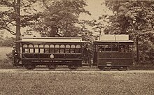
In the centuries that followed the development phase of Wilhelmshöher Allee, the rural areas bordering the avenue were systematically built on, so that the buildings slowly merged into one another and the villages that were directly adjacent to one another gradually became districts of Kassel. Since then, the former country road has been an inner-city road. The Kassel tram has been traveling the entire length of the avenue since 1877 .
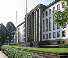
After Kassel was declared the district capital in 1934 , Wilhelmshöher Allee was also to be expanded into a gigantic boulevard. The road should be widened many times over. Only in the newly planned row of houses was the so-called “General Command”, today the seat of the Federal Social Court .
During the Second World War , numerous buildings in the districts on Wilhelmshöher Allee fell victim to the bombs , especially on the night of October 22-23, 1943, when, for example, the city center of Kassel was badly damaged by a British air raid . As a result, the 150-year-old appearance was seriously destroyed.
The reconstruction and new construction of houses, which has gradually been taking place since the 1950s, changed the appearance of the avenue, which was mostly only two-lane before the war, with the development and thus the districts growing together even more. In some places, however, there are still buildings from the Wilhelminian era . In the 1970s the street was widened. The old trees between the city center and the Wahlershausen district fell victim to this intervention to a large extent.
The avenue also underwent major redesigns due to the costly new construction of the Kassel-Wilhelmshöhe train station (late 1980s to early 1990s), which opened on May 29, 1991 with a spacious tram junction and bus station under a large canopy.
Nowadays Wilhelmshöher Allee is lined with numerous shops, cafés and restaurants, some of which are located in shopping centers, hotels, various companies, residential buildings (such as the historic Wilhelmshöher Allee 118 ), the Kassel-Wilhelmshöhe train station, the Kurhessen thermal baths and clinics. Since the 1990s, an urban sub-center with an anthroposophical center (including a concert hall), high-quality retail outlets and numerous service providers has developed, especially immediately west of the Kassel-Wilhelmshöhe train station .
Web links
Individual evidence
- ↑ Figures on traffic volume according to the traffic volume map of the city of Kassel, as of 2010, online at https://www.kassel.de/verkehr-und-mobilitaet/verkehrszaehler/14_10_Verkehrsmodell_Analyse-Nullfall_2010_Kfz__DTVw5_.pdf accessed 2019-11-06
Coordinates: 51 ° 18 ′ 45 " N , 9 ° 27 ′ 59.8" E


