Bauna
| Bauna | ||
|
Bauna Viaduct over the Bauna near Guntershausen |
||
| Data | ||
| Water code | EN : 4292 | |
| location | District of Kassel , Hessen ( Germany ) | |
| River system | Weser | |
| Drain over | Fulda → Weser → North Sea | |
| source | in the Hohen Habichtswald on Ahrensberg 51 ° 18 ′ 8 ″ N , 9 ° 20 ′ 4 ″ E |
|
| Source height | approx. 465 m above sea level NHN | |
| muzzle | near Baunatal - Guntershausen in the Fulda coordinates: 51 ° 14 '10 " N , 9 ° 28' 11" E 51 ° 14 '10 " N , 9 ° 28' 11" E |
|
| Mouth height | approx. 144 m above sea level NHN | |
| Height difference | approx. 321 m | |
| Bottom slope | approx. 19 ‰ | |
| length | 17.2 km | |
| Catchment area | 47.37 km² | |
| Drain |
MQ |
334 l / s |
| Left tributaries | see below | |
| Right tributaries | see below | |
| Medium-sized cities | Baunatal | |
| Communities | Schauenburg | |

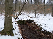
The Bauna is a 17.2 km long, western and orographically left tributary of the Fulda in the district of Kassel , northern Hesse ( Germany ).
course
The Bauna is created in the Hohe Habichtswald by the confluence of the Hinterer and Vorderer Bauna . In the Habichtswald Nature Park located sources of rear Bauna (in the upper reaches Small Bauna called, left source stream of Bauna) are in the range of Kaulenbergs ( 520.3 m ) to the north of Hoof , a municipality part of Schauenburg . The origin of the Near Bauna (right and longest river source of Bauna), the actual Baunaquelle (about 465 m above sea level. NHN ), located on the southern slope of Ahrens Berg (about 570 m ), which rises northwest of Hoof. The Vordere Bauna is bridged directly above Hoof by the route of the Kassel-Naumburg Railway (popularly: Naumburger Kleinbahn ).
Already above the junction of the source streams in Hoof, both enter the Hoofer Pforte , a valley basin between the Hohem Habichtswald (up to 614.8 m ) in the north and the Langenberg (up to 556.7 m ) in the south, which henceforth forms the course of the Bauna accompanied to the southeast.
The Bauna initially runs through Hoof, where it passes the Schauenburg castle ruins a little northeast. It then flows through Schauenburg- Elgershausen , where it is again bridged by the Kassel-Naumburg railway at the entrance to the town and after which it touches the flood retention basin Polder Schefferfeld .
Immediately afterwards, the stream is bridged by Landesstraße 3215 (former federal highway 520 ), after which it flows through Baunatal , passing the wooded Baunsberg ( 413.4 m ) to the south and running through the Baunataler Stadtpark . In Baunatal the Bauna flows through the districts of Altenritte , Alten- and Kirchbauna and Guntershausen . In the last-mentioned district it is spanned by a bridge on the Bebra-Baunatal-Guntershausen railway line as part of the Bauna Viaduct .
Finally , the Bauna flows directly east of Guntershausen around 1.5 km (as the crow flies ) north-northeast of the confluence of the Eder into the Fulda, flowing from the west at around 144 m altitude directly above the Fulda river kilometer 42.4 into the Fulda coming from there from the south .
Catchment area and tributaries
The tributaries of the Bauna, whose catchment area is 47.37 km², include these rivers with orographic allocation (l = left-hand side; r = right-hand side), length in kilometers (km), and the estuary with Baunabach kilometers downstream :
Source streams:
- Vordere Bauna (r; 3.15 km as part of the total length of 17.2 km of the Bauna), north-western, longest source stream, coming from the Ahrensberg , confluence in Hoof (km 14.05)
- Rear Bauna (l; 1.55 km), north-eastern source stream, coming from Kaulenberg , confluence in Hoof (km 14.05)
- Rehgraben (l; 1.7 km), tributary of the Hinterer Bauna, coming from Hohen Gras (km 0.95)
- Firnsbach (1; 3.2 km), northern tributary, coming from the Ziegenkopf ; flows between Schauenburg- Hoof and - Elgershausen (km 13.35)
- Fischbach (1; 2.1 km), northern tributary, coming from Dachsberg ; flows between Elgershausen and Baunatal- Altenritte (km 11.42)
- Lützel (r; 5.1 km), western tributary, coming from Saukopf ; flows into Altenritte (km 9.2)
- Leisel (r; 6.2 km), western tributary, coming from Schwengeberg ; flows between Baunatal- Altenbauna and - Kirchbauna (km 6.5)
leisure
In the valley of the Bauna runs a section of the Kassel-Naumburg Railway , which crosses the stream twice and on which the Hessencourrier Museum Railway operates, part of the Hessencourrier Cycle Path and the Baunapfad , the hiking trail that leads from the source to the mouth of the stream. Its source streams are crossed by the Ederseeweg , Habichtswaldsteig and Kassel-Steig , and the stream itself is crossed by the Herkulesweg .
Individual evidence
-
↑ a b Source height according to the mean value ( 465 m ) from topographical hiking maps :
- approx. 470 m : Kassel-Steig - a panorama trail around the Kassel basin ;
M = 1: 31,250; 2 pages; 2012; Ed .: City of Kassel, surveying and geographic information
- approx. 460 m : Habichtswald cycle and hiking map , from Kassel to Twiste and Edersee:
M = 1: 33.333; Ed .: Geo-Verlag (Kaufungen) - ↑ a b Topo-Map: Kassel-Steig - A panorama path ... (see individual list of source height )
- ↑ a b c d e Water map service of the Hessian Ministry for the Environment, Climate Protection, Agriculture and Consumer Protection ( information )

