Rothenditmold
|
Rothenditmold district of Kassel |
||
|---|---|---|
| Coordinates | 51 ° 19 '51 " N , 9 ° 28' 25" E | |
| surface | 2.76 km² (14/23) | |
| Residents | 7472 (Dec. 31, 2019) (16/23) | |
| Population density | 2707 inhabitants / km² (11/23) | |
| Proportion of foreigners | 39.8% (Dec. 31, 2019) (2/23) | |
| Incorporation | Apr 1, 1906 | |
| Post Code | 34127 | |
| prefix | 0561 | |
| Website | District info Rothenditmold | |
| politics | ||
| Mayor | Hans Roth (AUF-Kassel) | |
| Allocation of seats (local advisory board) | ||
|
||
| Source: Kassel Statistical Atlas | ||
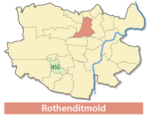
Rothenditmold is one of 23 districts of the north Hessian city of Kassel ( Hesse , Germany ).
geography
The Rothenditmold district is located northwest of the Mitte district . Looking clockwise from the north, the districts of North Holland , Mitte, West , Kirchditmold , Harleshausen and the Jungfernkopf in the northwest . Rothenditmold is cut through by Wolfhager Straße, which leads from Holländischer Platz in the direction of the outer districts of Kirchditmold and Harleshausen. In the opposite direction, the Geilebach coming from the Habichtswald , which is called "Döllbach" from the track field of the former repair shop, runs below the Rothenberg towards Möncheberg. From the former hammer mill, the stream has been piped as "Mombach" since 1908 and runs under the street of the same name past the main cemetery and slaughterhouse until it flows into the Ahna at the level of the Nordstadtpark .
history
The place "Roden-Ditmelle" was first mentioned in a document in 1219. The name suffix "Ditmelle" also appears in the neighboring district of Kirchditmold , with which an original market community is said to have existed. The district existed as an independent municipality between the Bruchwassern below the Kratzenberg and the areas of the Niederfeld in the west and the Mittelfeld in the northeast, divided by the ridge of the Rothenberg, until it was incorporated into Kassel in 1906. As a result of Kassel's connection to the railroad in 1848 the village below Kassel's main train station rapidly developed into an industrial working-class district. With the establishment of the company "Sehte und Kribben" in 1871, the forerunner of the Wegmann & Co. wagon factory was established . In the course of the expansion of the Henschel company , its Rothenditmold plant was founded and soon became the largest and most formative part of the village. In 1882, in addition to a spinning mill , the Schöfferhof brewery soon existed below the Rothenberg. The population rose rapidly from only 589 in 1864 to 1279 in 1871, 2759 in 1885 to 4003 in 1895 and 5250 in 1905.
The Rothenberg settlement on the hill above the town center was planned by Otto Haesler between 1927 and 1929 shortly before the start of the global economic crisis and implemented as a communal social housing of the early industrial modern.
The district suffered severe damage during the Second World War from Allied air raids on the factories and railways.
The area of the old industry, divided by the rail connection to the lower town station, is now used in the southern area by the arms company Krauss-Maffei Wegmann (KMW), a successor to Wegmann & Co. The structure of the district of small shops, bakeries, fruit and vegetable dealers, butchers and restaurants lasted well into the 1980s. Since then, concentration and vacancy have determined the picture in the district.
At the foot of the Rothenberg, the Hessenkolleg and the Anne Frank House have been run as youth and training facilities since 1962 .
The district has been included in the funding of European urban conservation and development programs since 2011.
Transport links
The Rothenditmold district is traversed in an east-west direction by Wolfhager Strasse (part of the B 251 ). The bus line 10 connects Waldau and the western part of Harleshausen. Coming from Bettenhausen, bus line 13 takes you to Philippistraße via Rothenberg and Nordstadt to Wolfsanger and to Ihringshäuser Straße . On the Rothenberg, line 12 runs from the main station to the Mittelfeld plant.
Footnotes
- ^ "Rothenditmold, City of Kassel". Historical local dictionary for Hessen. (As of September 22, 2015). In: Landesgeschichtliches Informationssystem Hessen (LAGIS).
Web links
- Site of the local advisory board at www.stadt-kassel.de ( Memento from February 12, 2013 in the web archive archive.today )


